It’s that time again: Hurricane season starts today
Living at the coast is pretty amazing for the most part. We say “for the most part” because there is one key exception to the rule: Hurricane season, which resumes today and will run through November 30. Once again, we’ll be monitoring the tropics with vigilance throughout the summer and fall, watching for potential threats to the Carolina coastline that might require us to hide our cows and head west.
As has been the pattern for many years now, seasonal forecasters are once again concerned about above-normal activity in the Atlantic basin, particularly closer to home with very warm water in the Gulf (though warm water doesn’t necessarily a busy season make). We don’t dwell too much on the seasonal forecasts here, because one storm is enough to make a particular hurricane season memorable for all the wrong reasons. Ultimately, we in the weather enterprise want you to be prepared for whatever might come our way.
This year’s names
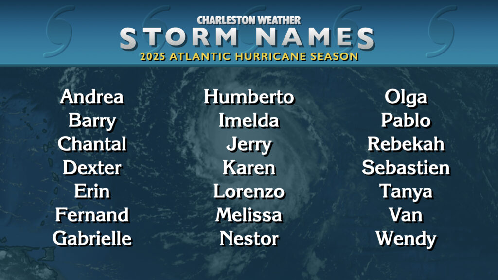
This year’s list of names has its roots in a list that started in 1983 and was last used in 2019. The only name retirement in 2019 was Dorian, which has been replaced by Dexter this year.
If we run out of names, we go to the supplemental list:
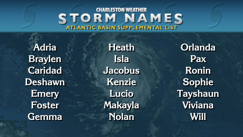
The supplemental list was implemented after the hyperactive 2020 season. Previously, the Greek alphabet was used, but many Greek letters sound the same which was shown to confuse the public. Worse yet, two of the storms that were named after Greek letters that year, Zeta and Eta, were major, damaging storms that caused loss of life and would have needed to have their names retired.
Prepare today, avoid stress tomorrow
The best time to get ready for hurricane season is when it’s quiet in the tropics, as it has been today and so far during the pre-season. The South Carolina Emergency Management Division has an excellent hurricane guide with everything you’d need to know, including what to put in your preparedness kit as well as your evacuation zones in case, God forbid, we need to get everyone out of the way of a storm. Evacuation zones changed markedly in 2024, and if you aren’t clear on which evacuation zone you’re in (or even if you are!), it’s important to check the Know Your Zone tool so you have the latest information.
Why you should use the NHC forecasts for your decision-making
Let’s get this out of the way: The official National Hurricane Center forecast, paired with local statements from the National Weather Service in Charleston, should be the basis for your decision-making. It’s somewhat incredible just how much weather model data is now available on the Internet, but you should never rely on a spaghetti plot of possible tracks to judge your risk because those models may not be reliable for all scenarios. The models are just a piece in a complex forecast puzzle that the experts use to create the forecast. The National Hurricane Center forecasters are some of the best in the world at this; lean on and trust that expertise!
When looking at the forecast, there’s also the matter of the Cone of Uncertainty and what that ultimately means. Simply put, the cone is a graphical representation of where the center could track 66% of the time, and is based on the average track error over the past five years. It is updated every year, and is shrinking a bit this year over last year, owing to continued improvements in track forecasting.
Hurricanes, though, are not a point on a map, they are sprawling complexes of bad weather whose effects can stretch hundreds of miles from that point. In other words, just because the cone may not come over a particular area, that doesn’t mean that area is necessarily in the clear. To help drive this home, NHC is continuing its experiment with graphics that show the inland extent of tropical storm and hurricane watches and warnings, and I’ll be right there with my own graphics once again as well.
Hurricane season can be anxiety-inducing, but we will be fine
Storm anxiety tends to peak during hurricane season, especially for those who may have been through the brunt of one. Hugo, despite happening over 35 years ago, still rings very fresh in the minds of the Charlestonians who rode it out, and they will tell you it wasn’t a whole lot of fun.
The best way to confront storm anxiety is to get prepared — have what you need ready to go so that you don’t have to get into the anxious throngs of people who aren’t prepared if a storm ends up threatening us.
It’s also important for most of us to not obsess over the tropics in our day-to-day lives (unless that’s something you’re highly interested in). Check back with the outlooks periodically; I and every other weather-adjacent media outlet in the area will keep you posted on what’s happening out there in a matter-of-fact way that leans on science and facts. We’re all quite judicious about raising the alarm, too. There are a lot of alternative sources out there these days that pop up on Facebook along with other social media sites and quite literally profit off scaring the bejeezus out of people with Scary-Looking Model Runs that end up not panning out. The rampant misinformation in the aftermath of Hurricane Helene on social media really drove home the point that it’s more important than ever before to ensure you’re listening to and sharing trustworthy sources of information.
Finally, we’re all in this together, and in the end, we’ll be fine, especially if we all get ready during the quiet times in case things become decidedly less-than-quiet. And remember: Enjoy your summer, because if you don’t, the hurricanes win.
Follow my Charleston Weather updates on Mastodon, Bluesky, Instagram, Facebook, or directly in a feed reader. Do you like what you see here? Please consider supporting my independent, hype-averse weather journalism and become a supporter on Patreon for a broader look at all things #chswx!