The week ahead: Fewer storms, but more heat
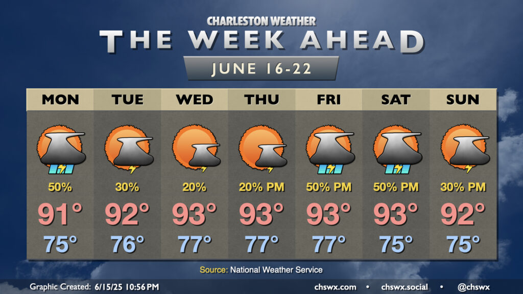
The good news for this week’s weather is that we’ll see a bit more of a lid put on the atmosphere as we get into midweek, which should help to decrease the coverage of — but not eliminate completely — afternoon showers and thunderstorms. The tradeoff, though, is that it’s going to get hotter, with heat indices creeping toward 105° for the first time this year.
Monday starts off in the mid-to-upper 70s, with dewpoints not too far from there making for a muggy start to the day. (This will basically be the trend all week, too.) Evening high-resolution models suggest even less thunderstorm coverage than Sunday, but given plenty of available instability and the inland-moving seabreeze, I wouldn’t bet against scattered to possibly numerous showers and thunderstorms in the afternoon. Temperatures will top out in the low 90s away from thunderstorms, and combined with the mid-70s dewpoints, it’ll feel closer to 102-103°.
As we get into Tuesday, though, the Atlantic ridge aloft begins to strengthen a bit more. This will help put more of a cap on the atmosphere, which will limit just how many storms can get going even as the seabreeze pushes inland. This has the net result of turning us warmer, too, with temperatures in the low to mid-90s in the afternoon. Heat indices will start to push toward 105°, which is increasingly dangerous for heat stroke concerns (though still shy of the Heat Advisory criteria of 108°).
Heat and humidity with little in the way of thunderstorm relief continues for Wednesday and Thursday as we get well into the longest stretch of 90°+ temperatures so far this year. (The previous stretch was June 6th through 9th.) Heat illness risks will continue to come along for the ride each afternoon, too, so be sure to get plenty of water and rest if you are working or playing outdoors. Shower and thunderstorm chances will be at their lowest on Wednesday and Thursday before a front might push toward the area on Friday and Saturday aided by a trough moving through the Great Lakes. Ridging then rebuilds in the wake of the trough, sending storm chances down a bit for Sunday.
Follow my Charleston Weather updates on Mastodon, Bluesky, Instagram, Facebook, or directly in a feed reader. Do you like what you see here? Please consider supporting my independent, hype-averse weather journalism and become a supporter on Patreon for a broader look at all things #chswx!