Rest of the work week: Heat continues; storm chances increase
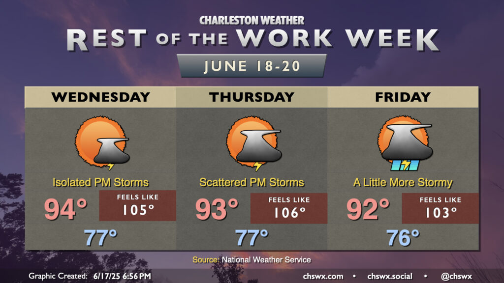
The rest of the work week will remain quite warm, especially Wednesday and Thursday as less in the way of showers and thunderstorms are expected before a trough of low pressure and accompanying front swing through to stir up more storms for Friday.
For Wednesday, expect another very warm and muggy day, with perhaps a storm or two to cool a few of us off in the afternoon (though most of us shouldn’t count on it). We’ll start the day in the upper 70s, warming to the mid-90s in the afternoon. Add mid-70s dewpoints to the mix, and that’ll yield heat indices around 105° during peak heating. When heat indices start to reach the 105° mark, we start to see the risk of heat illness begin to increase. HeatRisk, an experimental index to categorize the risk for heat illness, rises to the Major category (level 3 out of 4) for Wednesday away from the immediate coast. At that level, it becomes crucially important to ensure you get plenty of rest and hydration. With that in mind, this is also not uncommon for this part of the world, and the heat index of 105° falls a few degrees short of the local National Weather Service heat advisory criteria of 108°. Still, even with no advisory, please take it easy if you must be outdoors!
Despite a slightly “cooler” high temperature (a frigid 93°) on Thursday, dewpoints will begin to increase further ahead of the aforementioned front. This will help heat indices head even a touch warmer than Wednesday’s as a result, peaking around 106° in the afternoon. Shower and storm chances will tick up later in the evening as the front draws nearer, potentially sending a decaying thunderstorm complex our direction, but we’ll see how things ultimately play out.
Friday will be the stormiest of the bunch, but once again this will be generally in the afternoon and evening hours coincident with the height of daytime heating. A few storms could be stronger with the mid-level energy swinging through, so we’ll want to watch that. Temperatures will peak in the low 90s, with heat indices peaking around 103° or so.
Follow my Charleston Weather updates on Mastodon, Bluesky, Instagram, Facebook, or directly in a feed reader. Do you like what you see here? Please consider supporting my independent, hype-averse weather journalism and become a supporter on Patreon for a broader look at all things #chswx!