Weekend forecast: A stray storm or two, but otherwise on the warm side
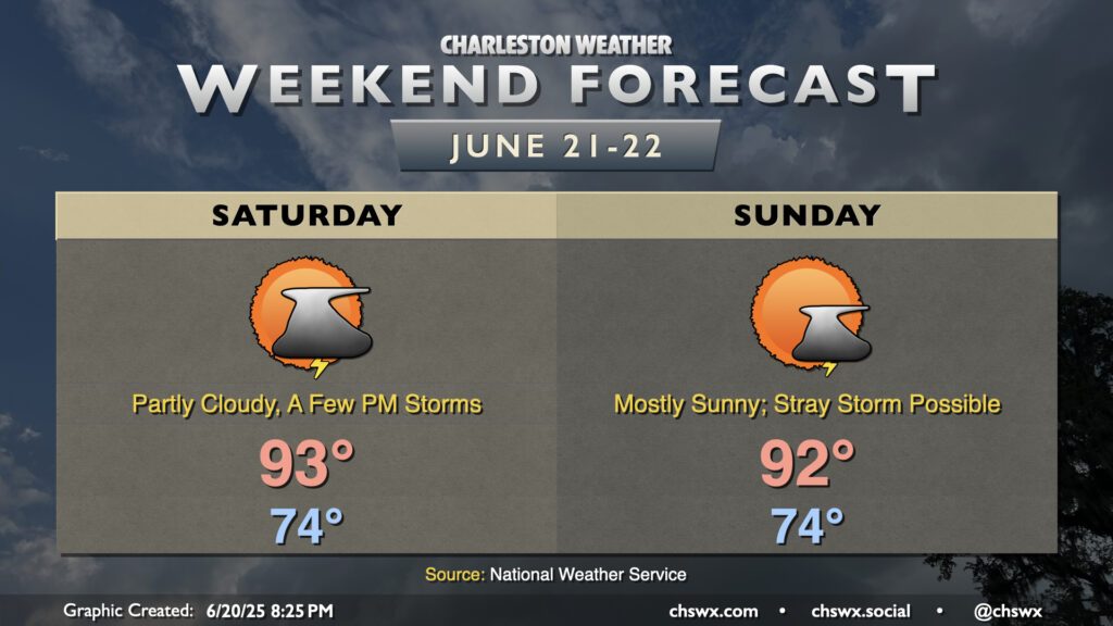
Summer heat will continue this weekend with limited chances for a few storms to cool things off. Saturday will start in the mid-70s, warming to the low-to-mid-90s in the afternoon. Mix in dewpoints in the low 70s, and it’ll feel more like the mid-to-upper 90s. There will be a bit more moisture available Saturday, which could allow for slightly greater storm coverage as the seabreeze pushes inland during the afternoon. However, most of us shouldn’t count on a storm to cool things off. Any storms that fire will dissipate with the loss of daytime heating.
A stray storm or two will be possible Sunday, but the vast majority of us should stay rain-free as dewpoints once again mix down to the low 70s in the afternoon owing to a lot of dry air aloft. We’ll warm to the low 90s, but the lower dewpoints keep heat indices relatively in check, only running a few degrees above the air temperature. That’s not to say that feeling like the mid-90s is in any way “cool” though!
Heat builds for next week
As we head into next week, an anomalously strong ridge of high pressure will build across the Mid-Atlantic. This will allow heat to continue to build across the area, and we’re in for an extended stretch of mid-90s heat as a result. With dewpoints in the low 70s, it’ll feel like triple digits each afternoon, especially in the immediate wake of the seabreeze when heat indices could briefly spike over 105°. This falls short of the Heat Advisory criteria of heat indices between 108°-112°, but is still plenty toasty. You’ll want to make sure you’re getting plenty of water and time in the shade if you’ll be outdoors each afternoon.
The other concern will be the cumulative effect of the heat: lows bottom out generally in the mid-70s across the metro, but may struggle to drop below 80° at the coast. As of this writing, we’re on seven straight days of 90°+ heat and we should pretty easily tack on another seven days to this streak, especially as the ridge of high pressure suppresses thunderstorm development. Heat stress can build over time, and this can become especially problematic for vulnerable populations such as the elderly or the unhoused. So, even though it’s not going to be a stretch of heat that will necessarily break records for this area, it still can be dangerous over time. We’ll keep an eye on things, of course, and keep you posted as we get into next week.
Follow my Charleston Weather updates on Mastodon, Bluesky, Instagram, Facebook, or directly in a feed reader. Do you like what you see here? Please consider supporting my independent, hype-averse weather journalism and become a supporter on Patreon for a broader look at all things #chswx!