The week ahead: Turning rather warm with sparse storm chances
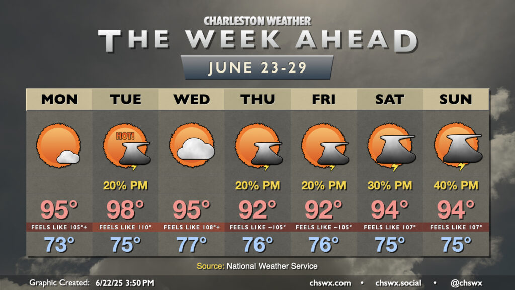
The main weather story this week will be heat, especially for the first part of the week as strong high pressure aloft affects much of the Eastern Seaboard.
We head into the upcoming work week with nine consecutive days of 90°+ highs, and that stretch will continue for the foreseeable future. We start Monday in the low-to-mid-70s, warming to the mid-90s in the afternoon under mostly sunny skies as high pressure and dry air suppresses much in the way of cloud, much less thunderstorm, development. Heat indices will peak around 105-106° in the afternoon, particularly in the immediate wake of the seabreeze.
Tuesday looks like the hottest day of the upcoming week. Lows bottom out in the mid-70s inland to near 80° at the coast, warming to the upper 90s in the afternoon. A couple spots might hit triple digits in air temperatures, but we’ll see how that evolves. Regardless of the air temperature, it’s going to feel very much like the triple digits, with heat indices perhaps approaching 110° in the afternoon. The heat advisory criteria is a heat index of 108° to 112°, and it looks as if we’re going to hit that criteria for the first time this year. A stray storm will be possible along the seabreeze, but don’t count on any storms to impart any relief on Tuesday.
The high pressure system starts to weaken some as we head into the second half of the work week. Temperatures will remain very toasty, with highs in the mid-90s on Wednesday and heat indices perhaps approaching advisory criteria again. Surface high pressure weakens further as we head toward the weekend, allowing more humid air to move in and increasing the risk for a few afternoon thunderstorms each day. Highs will continue to top out in the low 90s each afternoon, with heat indices in the mid-to-upper 100s away from any storms.
Follow my Charleston Weather updates on Mastodon, Bluesky, Instagram, Facebook, or directly in a feed reader. Do you like what you see here? Please consider supporting my independent, hype-averse weather journalism and become a supporter on Patreon for a broader look at all things #chswx!