Weekend forecast: Tropical mischief to bring rain, gusty winds, rip currents
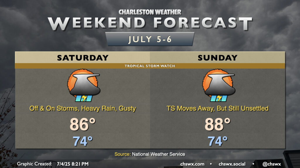
Tropical Depression Three developed this afternoon off the Southeast coast, and will be the main driver of our weather this weekend. Even though Three is forecast to become Tropical Storm Chantal, this should largely be a beneficial system, bringing some rain to some parched spots. However, it will still bring a few hazards, including gusty winds (40-45 MPH) near the coast and offshore, a high risk of rip currents, and the potential for locally heavy rain that could lead to some flooding, particularly around the afternoon high tide. This potential has prompted a Tropical Storm Watch for Charleston County. With all that said, though, this is nothing we can’t handle.
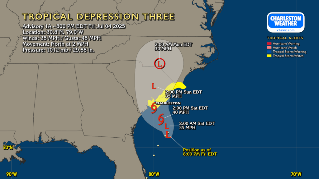
At 8PM, Tropical Depression Three had maximum winds of 35 MPH and was moving north very slowly at 2 MPH. Expect that motion to continue before it gradually begins to speed up toward the SC coast later Saturday into early Sunday morning. It’ll be a lopsided storm, with the deepest thunderstorms to the east of the center and likely staying offshore. However, we’ll still get some rain bands into the area beginning Saturday morning. We’ll experience the typical off-and-on nature of tropical rain bands, with gusty winds at times along with the heavy rain squalls. We’ll have periods of sun mixed in, too, but the rainfall should be enough to keep highs pinned to the mid-80s. That will bring the 90° streak at Charleston International Airport to a close at 21 days after reaching 90° again Friday afternoon. Winds will be breezy, especially the closer to the coast you are. Tropical storm conditions with gusty winds approaching 40 MPH will be confined to the beaches and offshore. We’ll keep an eye on the center position and the strength of the storm itself, but right now tornadoes do not appear to be a concern.
Three/future Chantal makes landfall early Sunday morning. The exact landfall point is important for where the heaviest rain will fall. Currently, it looks like the Grand Strand into southeastern NC gets the brunt of this system’s rain, but again, wobbles can make a difference. The cyclone will weaken to a depression (if it gets upgraded) as the center moves through the Pee Dee, gradually losing tropical characteristics as it goes. Showers and thunderstorms will remain in the forecast for Sunday, subsiding as we get into Sunday night as the center pulls away. Temperatures on Sunday will top out in the upper 80s, influenced largely by the rain and cloud cover.
We’ll turn hotter starting Monday, with the potential for advisory-level heat for several days next week. Enjoy the rainy cooldown while you can!
Follow my Charleston Weather updates on Mastodon, Bluesky, Instagram, Facebook, or directly in a feed reader. Do you like what you see here? Please consider supporting my independent, hype-averse weather journalism and become a supporter on Patreon for a broader look at all things #chswx!