Friday & the weekend: A little hotter, a touch less stormy
We should see more thunderstorms on Friday as mid-level energy continues to affect the area for one more day. High pressure then ridges in aloft for the weekend, warming temperatures up and taking storm chances down a notch.
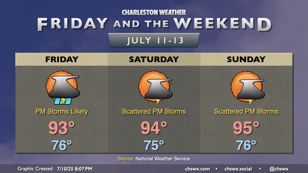
Friday will start in the mid-70s once again. The high-resolution models continue to point to the potential for a few thunderstorms to fire overnight near the coast, but we’ll see how this plays out. Barring another round of storms with lingering cloud cover, we should warm to the low-to-mid-90s in the afternoon before more thunderstorms develop across the area. The best risk for severe weather will be found inland, but a strong storm or two can’t be ruled out. Heavy rain and frequent lightning will continue to be the main concerns for any showers and thunderstorms that develop, but strong winds could come into play especially where storms develop due to boundary collisions.
From there, the mid-level energy works out of the area (finally) and high pressure starts to ridge back in overhead for the weekend. Highs Saturday generally run in the low-to-mid-90s once again, with more of a scattering of thunderstorms in the afternoon courtesy of the seabreeze and an inland trough. Sunday will be more of the same, with temperatures running perhaps a click or two warmer than they did on Saturday, with highs solidly in the mid-90s away from the coast. Once again, afternoon and evening thunderstorms will be possible, but not everyone will see a storm.
Follow my Charleston Weather updates on Mastodon, Bluesky, Instagram, Facebook, or directly in a feed reader. Do you like what you see here? Please consider supporting my independent, hype-averse weather journalism and become a supporter on Patreon for a broader look at all things #chswx!