Friday & the weekend: Heat turns up a notch; advisories possible
The story for Friday and the weekend will be the potential for dangerous heat as high pressure ridges in overhead and at the surface while dewpoints continue to run in the low-to-mid-70s, helping to keep overnight lows elevated to near record-warm levels and storm chances suppressed, worsening the risk for heat stress as a result.
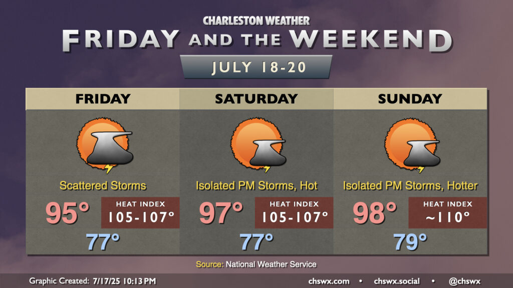
Friday starts in the upper 70s across much of the metro to near 80° toward the coast as well as in downtown Charleston. We’ll warm to the mid-90s in the afternoon as ridging continues to build in aloft. Storm coverage will generally be isolated to widely scattered, and whatever can get going probably will struggle against the increasingly dry air aloft.
Storms will be very hard to come by over the weekend, especially on Saturday, as the ridge’s strength peaks across the area. Another very warm morning will warm to the mid-to-upper 90s in the afternoon, and dewpoints in the mid-70s will yield heat indices approaching 107-108°, especially in the immediate wake of the seabreeze as dewpoints spike even a bit higher. A Heat Advisory will be possible. Sunday should run even a touch hotter, with lows struggling to fall below 80° across much of the metro (and almost certainly at the beaches) before highs soar back into the upper 90s in the afternoon. Heat indices could approach 110°, so be sure you’re getting plenty of fluids and taking frequent breaks if you must be outside. Check on the elderly and otherwise vulnerable as well, especially those who may not have reliable air conditioning, because overnight lows just won’t offer much in the way of relief.
The good news is that this hot spell is relatively short-lived. The ridge will start to retreat westward later Sunday, which will allow more disturbances to ripple across the area and increase shower and thunderstorm coverage generally starting Monday, which will impart some relief on the area.
Follow my Charleston Weather updates on Mastodon, Bluesky, Instagram, Facebook, or directly in a feed reader. Do you like what you see here? Please consider supporting my independent, hype-averse weather journalism and become a supporter on Patreon for a broader look at all things #chswx!