The week ahead: Searing hot start, but turning more unsettled
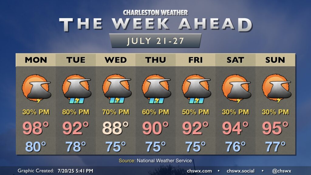
This weekend’s hot weather continues into Monday, but a more unsettled pattern will cool temperatures down back to normal (still not chilly, but not overwhelmingly hot, either) as rain chances tick back up.
The high pressure ridge that’s been baking us for the past few days will begin to break down on Monday as a front advances southward. However, we’ll have one more very hot day with highs in the upper 90s after a start to the day around 80°. A Heat Advisory will be in effect from 12-8pm as a result. Scattered showers and thunderstorms should develop in the afternoon, and a few of these could produce some strong wind gusts with some dry air still hanging in there aloft.
The front gets further into the area Tuesday into Wednesday and stalls out. It’ll cool us off a touch — upper 80s to low 90s as opposed to upper 90s — and increase the risk for showers and thunderstorms for the next few days. The vast majority of us should see some rain, and some heavy rain will be possible at times as well, so stay alert for possible Flood Advisories.
Heading into the second half of the week and into next weekend, we’ll see some ridging aloft begin to rebuild a bit, and temperatures will respond, warming into the mid-90s in the afternoons by Saturday. Scattered showers and thunderstorms will remain in the forecast, but rain chances will generally run a bit lower.