Friday & the weekend: One more hot day, then turning cooler — and stormier
The end to the heat wave is in sight, but we have one more day to go before a front moves in from the north, replacing the oppressive heat with numerous showers and thunderstorms for the weekend. (Sorry.)
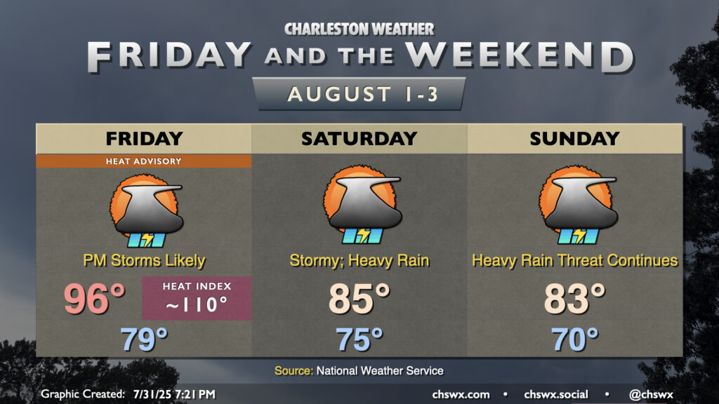
Friday starts once again in the upper 70s inland to low 80s near the coast, warming to the mid-to-upper 90s in the afternoon. The continued humid air will help drive heat indices upwards of 110° particularly closer to the coast, and this is where a Heat Advisory will be in effect from 11am-8pm. (It’ll still be hot elsewhere, though, advisory or not.)
High-resolution guidance suggests that showers and thunderstorms will begin to fire across the area in the 3-4 PM timeframe, initially with the inland push of the seabreeze. The aforementioned front then joins the party later in the evening, adding another trigger for additional shower and thunderstorm development. A couple storms could be on the strong side, with damaging wind gusts the main severe weather concern. More folks will feel impacts from heavy rain, though, and this promises to be a bit of a soggy weekend, with totals of 3-5″ of rain possible before it’s all said and done.
Saturday will turn noticeably “cooler” — partially the work of the stalling front, and partially the continued shower and thunderstorm coverage. Mid-70s lows warm to just the mid-80s on Saturday. We’ll run even a little cooler on Sunday, with lows dropping to around 70° and temperatures only warming to the low 80s in the afternoon. We may see the coolest afternoon high since June 4 at the airport, when it was 81°. Unfortunately, the more comfortable temperatures will continue to come with the risk for heavy rain and possible flash flooding, particularly as we get into Saturday evening through early Sunday. Flood advisories and flash flood warnings are possible, so be sure you are keeping an ear out for weather alerts from the National Weather Service. While it won’t rain all day at any one location, it could come down in buckets when it does rain.
New flash flood criteria going into effect on Friday
The National Weather Service in Charleston will return to issuing “base” Flash Flood Warnings starting Friday. Previously, NWS Charleston reserved Flash Flood Warnings for higher-end flood events that would trigger phone alerts. These “base” Flash Flood Warnings don’t trigger phones, and would be issued for many cases in urbanized areas where Flood Advisories are used today for situations where, for instance, roads are flooded and closed. The criteria for the higher-end “considerable” Flash Flood Warning, which triggers emergency alerts on phones, hasn’t changed. This kind of Flash Flood Warning would continue to be issued if roads begin to wash out, there are a few swift water rescues from vehicles, water starts entering buildings, or streams and creeks exceeded their moderate flood stage. (Let’s hope a “catastrophic” Flash Flood Warning/Flash Flood Emergency doesn’t grace our weather wires again for a long time.)
So, if you see an uptick in Flash Flood Warnings coming across your weather radio, weather app, favorite @chswx bot, etc., you’ll know why. It’s conceivable that the new criteria will be almost immediately tested this weekend given the hydrological setup with the stalling cold front, so stay tuned.
Follow my Charleston Weather updates on Mastodon, Bluesky, Instagram, Facebook, or directly in a feed reader. Do you like what you see here? Please consider supporting my independent, hype-averse weather journalism and become a supporter on Patreon for a broader look at all things #chswx!