Rest of the work week: Erin’s coastal impacts peak; more unsettled toward the weekend
The main story for the next couple days will be Hurricane Erin’s impacts on the Lowcountry. While not a direct hit — the storm will pass hundreds of miles offshore — the strong, dangerous rip currents and high surf will cause beach erosion and coastal flooding issues over the next few days.
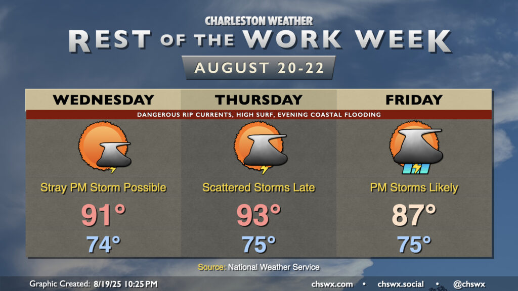
Overall, the next couple days of weather as far as rain and storms go will be reasonably quiet. Wednesday will feature the lowest rain chances of the rest of the week as the seabreeze maybe kicks off a storm or two, but otherwise, we stay quiet. Temperatures start in the mid-70s, warming to the low 90s in the afternoon; heat indices will run a few degrees warmer as dewpoints run in the low 70s.
Thursday should be mostly quiet during the day as well. We get off to another mid-70s start, and turn out even warmer in the afternoon as highs peak in the low-to-mid-90s. A few storms will be possible on the seabreeze in the afternoon, but more substantial rain chances will begin to move into the area later Thursday night into Friday as a front sags southward. Thunderstorms turn more likely as we head into Friday afternoon and evening, with elevated rain chances persisting through the weekend.
Coastal flooding threat peaks Wednesday, but lingers for the rest of the week
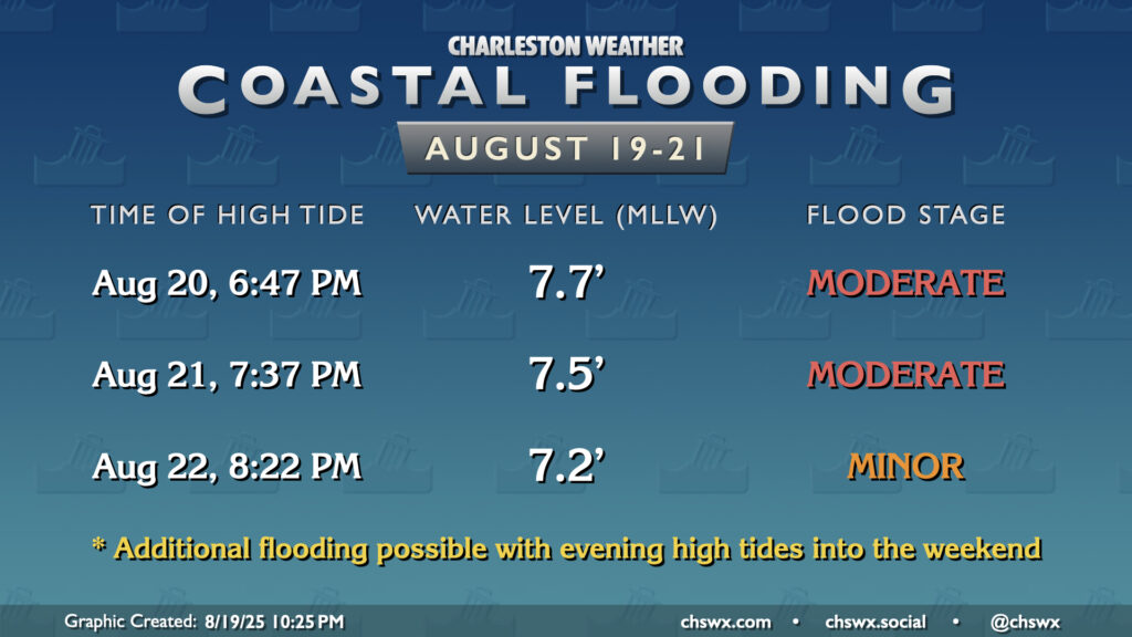
The risk for coastal flooding will be highest as Erin makes its closest pass on Wednesday. Expect moderate salt water inundation driven by a 7.7′ high tide peaking around 6:47 PM to close many roads downtown, including the 61/17 split heading into West Ashley from downtown. This could cause snarls during the evening commute, so be ready to reroute and, most importantly, be patient. Moderate flooding is again expected Thursday evening around the 7:37 PM high tide as water levels peak around 7.5′, while minor flooding is likely Friday night with water levels peaking in the 7.1-7.3′ range. We’ll want to watch Friday night, though, as the risk for rain will be higher.
Remember: Never drive around a barricade and through floodwater, especially salt water. Turn around, don’t drown!
Follow my Charleston Weather updates on Mastodon, Bluesky, Instagram, Facebook, or directly in a feed reader. Do you like what you see here? Please consider supporting my independent, hype-averse weather journalism and become a supporter on Patreon for a broader look at all things #chswx!