Weekend forecast: More heavy rain appears likely
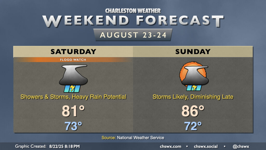
After record-breaking rainfall on Friday, more heavy rain appears likely for Saturday and to a lesser extent on Sunday as waves of low pressure along a stalled front continue to traverse the area, which has been well-moistened by an influx of tropical air.
Model guidance is mixed on timing of the thunderstorms, but there is a chance they could re-fire overnight and persist into Saturday morning, followed by another round of storms developing later in the afternoon and evening. Bottom line is that there will be a risk for slow-moving thunderstorms to again wring out a lot of water across the Lowcountry, with additional flash flooding a decent possibility. Tides should also be elevated Saturday evening, with the potential for another round of salt water flooding as well. And, of course, if heavy rain falls in advance of or around this high tide, flash flooding could become a widespread, serious concern particularly for downtown Charleston. About the only redeeming thing about Saturday’s forecast is the expected high temperature, which should remain pinned to the low 80s given the extent of cloud cover and thunderstorms.
A whiff of an upcoming pattern change kicks in for Sunday, but we should have one, maybe two more rounds of thunderstorms beforehand. We’ll start to see some drier air filter in, though, and this should shut off most of the thunderstorms by evening. Temperatures should run a little warmer with the downtick in thunderstorm coverage, allowing highs to peak back in the mid-80s.
As we get into next week, we’ll see temperatures fall well below normal for a refreshing fall preview as we head into Labor Day weekend. Highs in the mid-80s will be common by midweek with just a slight chance of a storm in the afternoon.
Record rainfall at both downtown and the airport
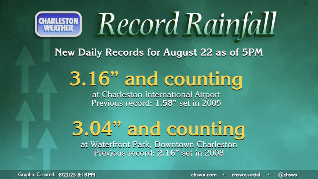
Unsurprisingly, the rainfall records fell rather quickly today at both downtown and the Charleston International Airport (where International Boulevard flooded for a time). As of the 5PM climate report, the rainfall total at the airport was 3.16″, breaking the record of 1.58″ set in 2005. At Waterfront Park downtown, 3.04″ fell, eclipsing the record of 2.16″ set in 2008. More rain has fallen since the 5PM climate report, and updated figures will be issued overnight.
Follow my Charleston Weather updates on Mastodon, Bluesky, Instagram, Facebook, or directly in a feed reader. Do you like what you see here? Please consider supporting my independent, hype-averse weather journalism and become a supporter on Patreon for a broader look at all things #chswx!