Rest of the work week: Warming trend commences
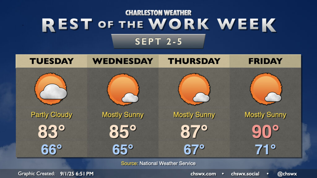
Mostly quiet weather is expected for the rest of the work week, with a warming trend taking us from the fall-like Labor Day weekend back to something a little more resembling summer by the end of the week, with highs back in the 90s by Friday.
First, though, we have a few more really nice days across the area. Temperatures on Tuesday start in the mid-60s, warming to the low 80s under generally partly cloudy skies. There’s an outside chance for a shower or storm near the coast with some energy moving by, but otherwise, much of us stay rain-free.
The warming trend starts to kick in a bit more on Wednesday, with highs in the mid-80s following a mid-60s start under mostly sunny skies. Dewpoints will still mix out to the low 60s, though, so even though it’ll be a couple degrees warmer, it should still feel just fine. Dewpoints do start to climb beginning Thursday, though, as the high pressure wedge weakens somewhat and winds go a little more southerly. Highs on Thursday peak in the mid-to-upper 80s, while Friday should peak around 90° with mostly sunny skies throughout. The stretch of days to dry out is awfully welcome after a soggy end to August, which led to the third-wettest August on record for downtown Charleston. Isolated to scattered storm chances return to the picture as we get into early next week.
Watching tides for possible minor coastal flooding
While not explicitly forecast, we’ll want to keep an eye on the afternoon/evening high tides this week for the potential for some minor tidal flooding given the persistent northeasterly flow, especially as we get into Wednesday through Friday as we approach the full moon on September 7.
Tropics: Quiet start to September outside of one area to watch
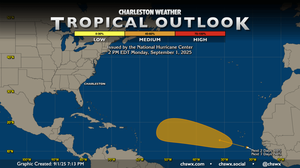
The tropics remain largely quiet as we head toward the climatological peak of the season on September 10. There is one area of interest south of the Cabo Verde Islands, though, that will bear watching as we get into next week. NHC gives this area a 50% chance to develop over the next week, and that probability should continue to increase as we get into the meat of this week. It’s a long, long way out there, and so we have plenty of time to watch whatever develops as it moves across the Atlantic.
Follow my Charleston Weather updates on Mastodon, Bluesky, Instagram, Facebook, or directly in a feed reader. Do you like what you see here? Please consider supporting my independent, hype-averse weather journalism and become a supporter on Patreon for a broader look at all things #chswx!