Weekend forecast: Storminess as we prepare for tropical issues next week
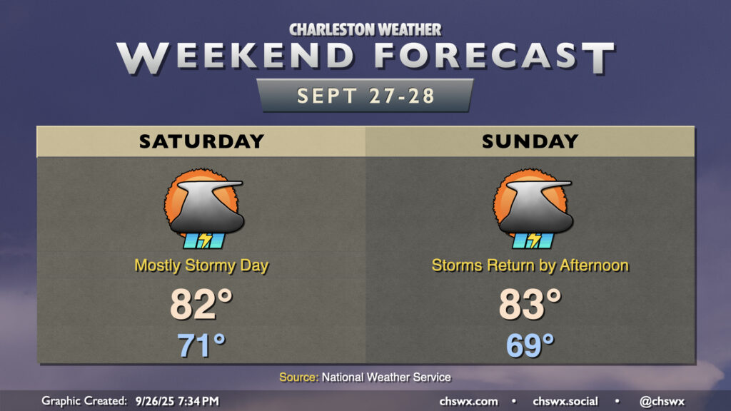
A slow-moving cold front combined with a stalling upper-level low will help spread rain further into the metro for the weekend, especially on Saturday, as we continue to monitor the progress of now-Potential Tropical Cyclone Nine.
We’ll likely wake up to widespread showers and thunderstorms across the area, with a small lull midday before daytime heating kicks back in and fires up more storms. Some storms could produce quite a bit of rain, and if storms begin to train, flooding could become a concern in spots. We’ve not had a ton of rain recently, and heavy rain on top of somewhat hardened soils can be a bit of a runoff risk, so that’s something we’ll want to monitor. We’re in a Slight Risk for excessive rainfall on Saturday for this reason. Stay alert for possible Flood Advisories or Flash Flood Warnings from the National Weather Service.
The front will meander offshore and stall out Sunday morning, keeping shower and storm chances initially closer to the coast to start the day. The approach of Nine — which will likely be named Imelda at that point — will begin to push the front back westward, increasing shower and storm chances further inland as we get into the afternoon and evening hours. Once again, there is a risk for heavy rainfall and some isolated bouts of flooding, so keep that in mind as you go about your Sunday.
High temperatures will run a touch below normal both days given the frontal passage, cloud cover, and rain.
PTC Nine/likely future Imelda to affect the area next week
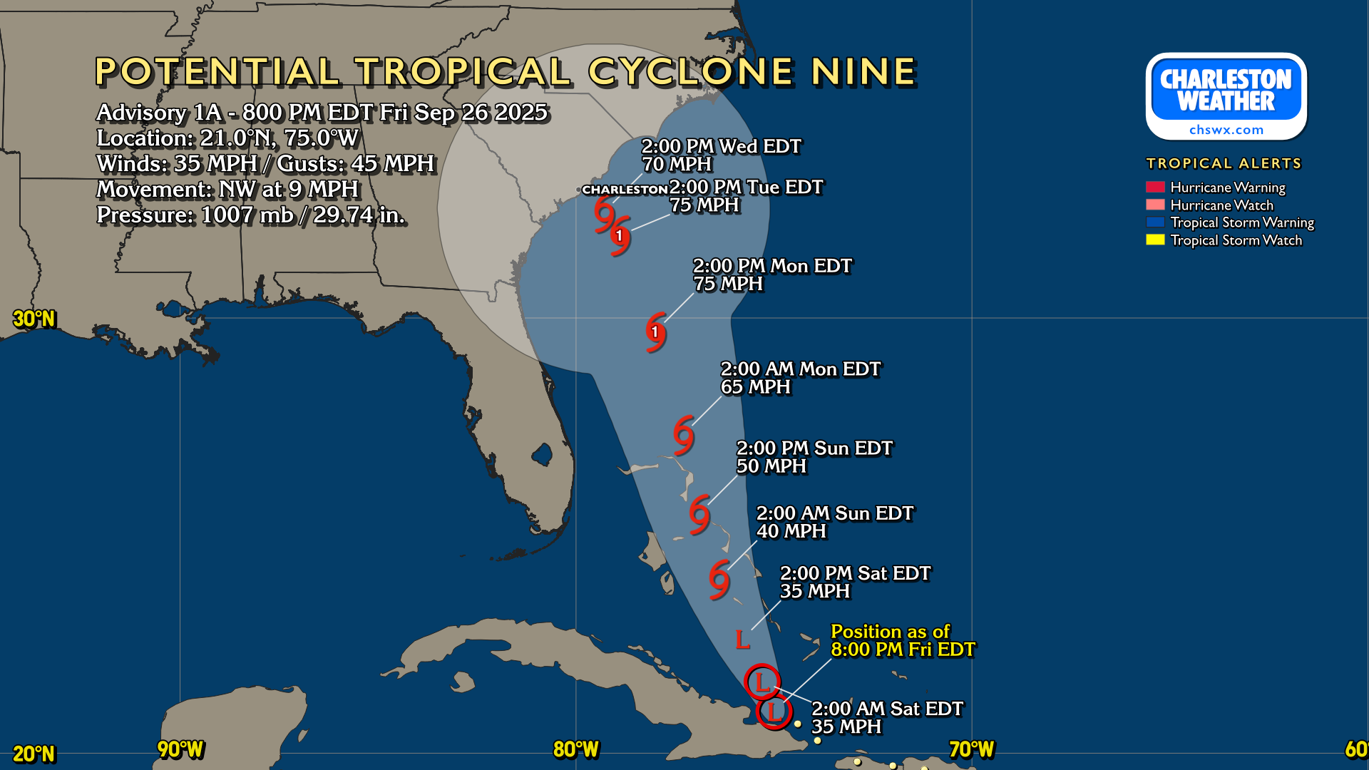
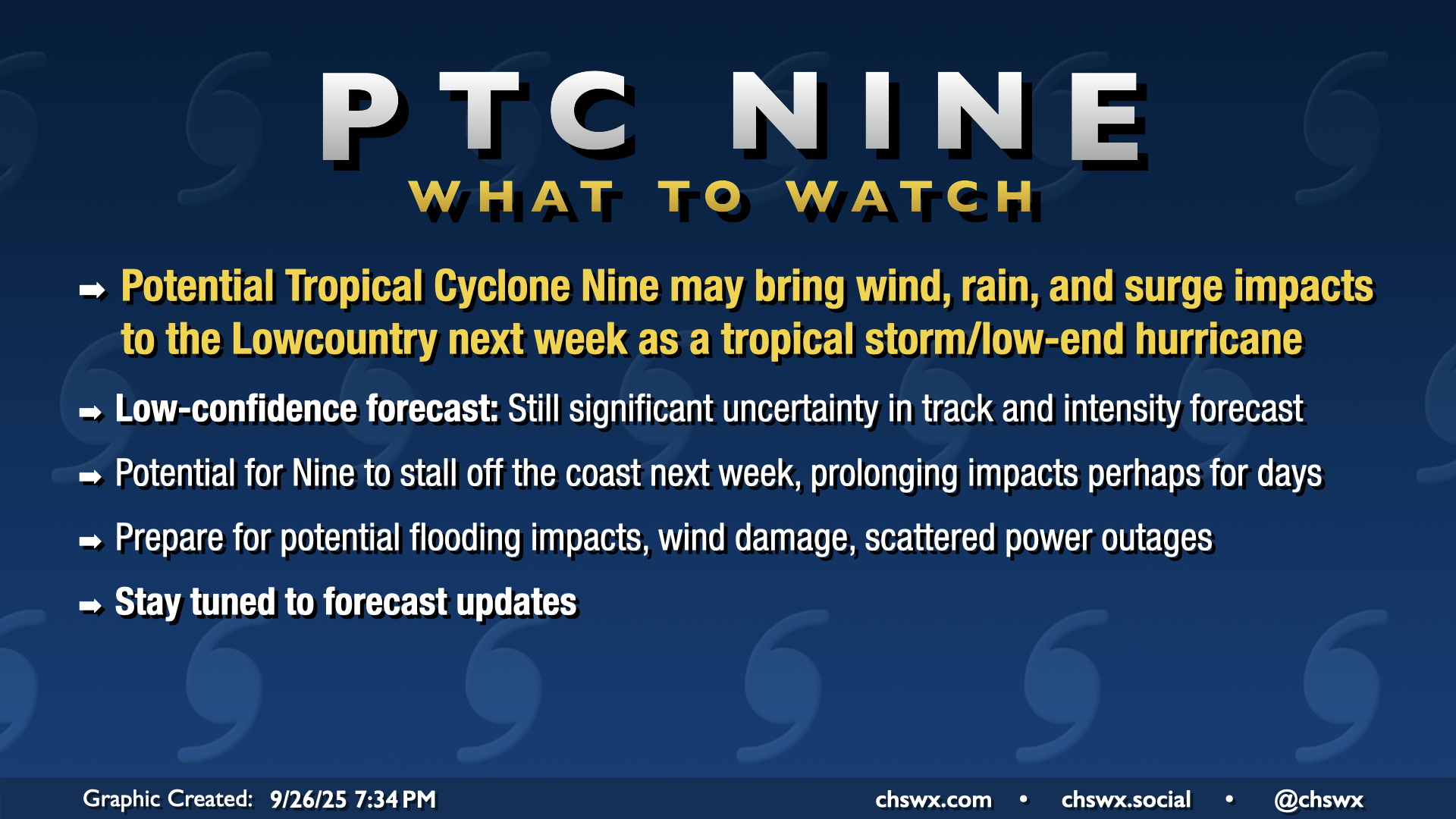
Potential Tropical Cyclone Nine continues to try to organize just north of Cuba this evening. Land interaction and shear will continue to work on the thunderstorm complex in the short term before relaxing on Saturday. This will allow the circulation to gather itself and finally form into a tropical depression by Saturday afternoon, according to the NHC forecast. From there, Nine continues to move northwestward through the Bahamas, slowly gaining strength and likely getting the name Imelda in the process (though that’s not always a given). By Monday afternoon, it will likely have strengthened into a hurricane as it continues on its northwestward trek. By Tuesday afternoon, though, the NHC forecast has the storm essentially stalling out just off our shores, keeping it in place through at least Wednesday. If this forecast verifies — definitely not a given at this point considering significant uncertainty that remains in the model guidance — we could see a prolonged period of heavy rain and wind across a good bit of the area. Storm surge will factor in along and north of the center along with the risk for tropical tornadoes. Again, though, so much of this initial thinking relies on details that are as yet unknowable, and we need more data to gain confidence in the forecast. A more northerly track mutes these impacts considerably for our neck of the woods, and vice versa. There’s even still the possibility that Humberto helps pull Nine/Imelda out to sea, minimizing our impacts locally. Unfortunately, it’s just wait and see at this stage.
Even though it will be raining, you will want to use the weekend to get your hurricane kits in order, review your safety plans, and check in on your evacuation zone. Better to be over-prepared than under-prepared for this sort of thing. On the current track, you’ll likely want to have your preparations largely wrapped up by Monday evening, when the risk for tropical storm force winds increases across the area (especially near the coast). If the stall scenario verifies, power outages could become widespread and somewhat long-lived, so keep that in mind as you gather supplies.
Finally, you’ll want to keep a close eye on the forecast as it is likely to undergo changes. We’ll be getting updated track and intensity forecasts every six hours going forward, with the next full update coming at 11pm followed by another update at 5am. Again, uncertainty is unusually high with this system, and the track and intensity forecasts still could be a bit volatile. So, make sure you’re using the official National Hurricane Center forecast for your decision-making. Model guidance is just that, and is only one part of what goes into the forecast. NHC forecasters time and time again end up being more accurate than the model guidance — they know what they are doing!
Follow my Charleston Weather updates on Mastodon, Bluesky, Instagram, Facebook, or directly in a feed reader. Do you like what you see here? Please consider supporting my independent, hype-averse weather journalism and become a supporter on Patreon for a broader look at all things #chswx!