Tropics: Good trend with TD Nine, but heavy rain and coastal impacts still expected
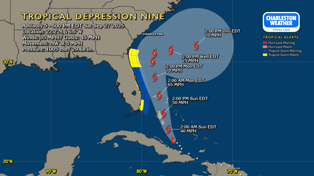
Tropical Depression Nine continues to organize, moving NW at 5 MPH on approach to the Bahamas, where Tropical Storm Warnings are in effect. Nine is still expected to strengthen, becoming a tropical storm tonight or early tomorrow morning. The next name on the list is Imelda.
On the current forecast from the National Hurricane Center, future Imelda will continue to move north-northwest heading into Monday, gradually strengthening into a hurricane (albeit a low-end Category 1). From there, it will stall out somewhere off the GA/SC coast Monday night into Tuesday, meandering until Humberto — a category 5 beast well out in the central Atlantic — gets close enough to help weaken the blocking high pressure to the north and “pulls” presumed Imelda eastward, away from the continental US.
Risk for impacts next week continues to come into focus
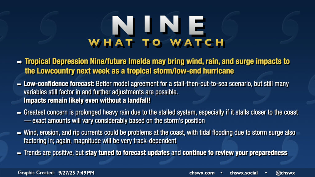
Today’s trend in guidance toward keeping Nine/future Imelda offshore is certainly positive, but it doesn’t mean that we get away scot-free (unless the eastward trend continues more substantially). Heavy rain remains the primary concern across the area, especially if future Imelda gets closer to the coast or stalls out longer. Model guidance is generally advertising about 3-6″ of rain across the area, with locally heavier amounts possible. A wobble back west could increase the risk of some locations receiving upwards of 10″ of rain. Conversely, a wobble further east would reduce the amount of rain we’d get.
There will be a tidal flooding threat as well as strong and persistent onshore winds on the north end of the stalling circulation could drive some surge. No official storm surge forecast has been published just yet, but the initial thinking from NWS is 2-4′ of surge provided the offshore forecast verifies. We’ll see how this ultimately works out, but regardless, we’ll be watching times of high tide for salt water flooding in addition to any freshwater flooding that occurs due to heavy rain.
On the current track, the risk for tropical storm-force winds will generally be confined to the coastal areas, including downtown. Once again, the further west it tracks, the greater the risk for those winds to spread inland, so this is a variable to watch. Timing for these winds remains a bit up in the air, but on the current forecast track, expect winds to kick up starting Monday night or Tuesday morning. With those winds will come the risk for beach erosion and rip currents as well, with a high risk of rip currents starting Monday. (We’d have rip current issues anyway, courtesy of Humberto.)
What to do tomorrow
The most important thing you can do is to continue to monitor the forecast for any changes and continue your preparedness activities. Trends are certainly positive for a relatively benign rendezvous with Imelda, but there are many variables at play still, and a tweak a little west could make for more significant impacts across the area. And while increasingly unlikely, a landfall scenario remains on the table if Humberto’s effects on the high to the north don’t materialize the way we expect. So, we in the weather enterprise continue to recommend preparation for power outages, flooding, and possible wind damage (particularly at the coast). With any luck, we should avoid too many issues, but let’s not just rely on luck. 🙂
Follow my Charleston Weather updates on Mastodon, Bluesky, Instagram, Facebook, or directly in a feed reader. Do you like what you see here? Please consider supporting my independent, hype-averse weather journalism and become a supporter on Patreon for a broader look at all things #chswx!