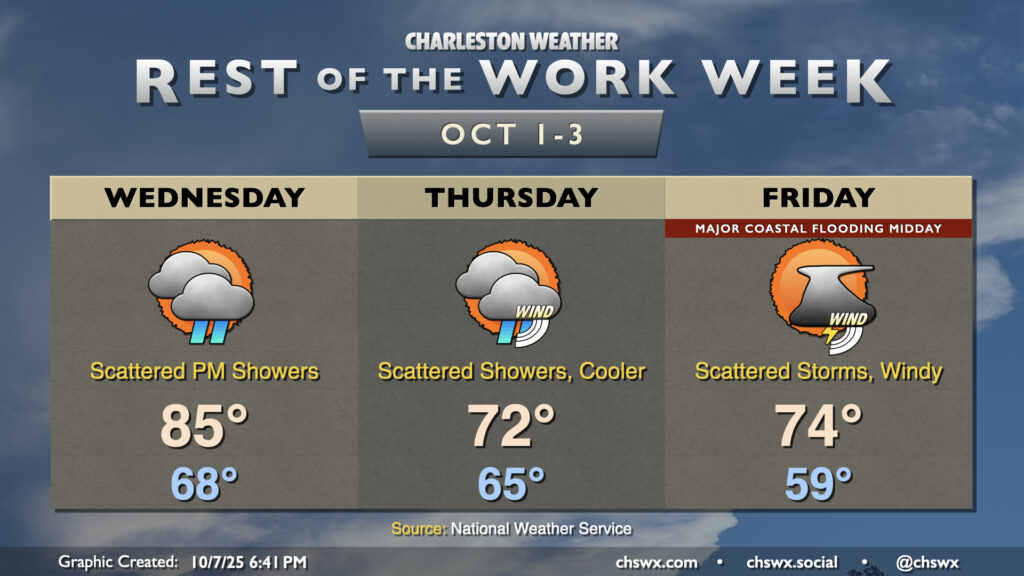
Rest of the work week: One more warm day, then cooling sharply as coastal flood threat escalates
Occasionally unsettled and breezy conditions will continue for the next few days as a front moves through, high pressure builds in, and low pressure spins up offshore.
We’ve got one more seasonably warm day coming up ahead of the front on Wednesday. Lows will be on the warm side of normal once again, generally running in the upper 60s to around 70° or so, warming to the mid-80s in the afternoon. Shower chances increase with the approach of the front Wednesday afternoon, but the best chances for rain arrive later in the evening through the overnight. We’ll see winds start to kick up as the front comes through, and that’ll usher in a few breezy days beginning Thursday. Temperatures will run much cooler Thursday as high pressure wedges southward into the area, with shower chances hanging around. Highs only peak in the low 70s after a mid-60s start. Friday morning will run quite cool, with lows in the upper 50s to around 60° expected. Shower and storm chances persist, and winds will stay breezy with gusts 25-30 MPH possible, particularly at the coast. Highs once again peak in the low to mid-70s, still a bit below normal for early October.
Coastal flooding threat increases, with major flooding possible Thursday and Friday
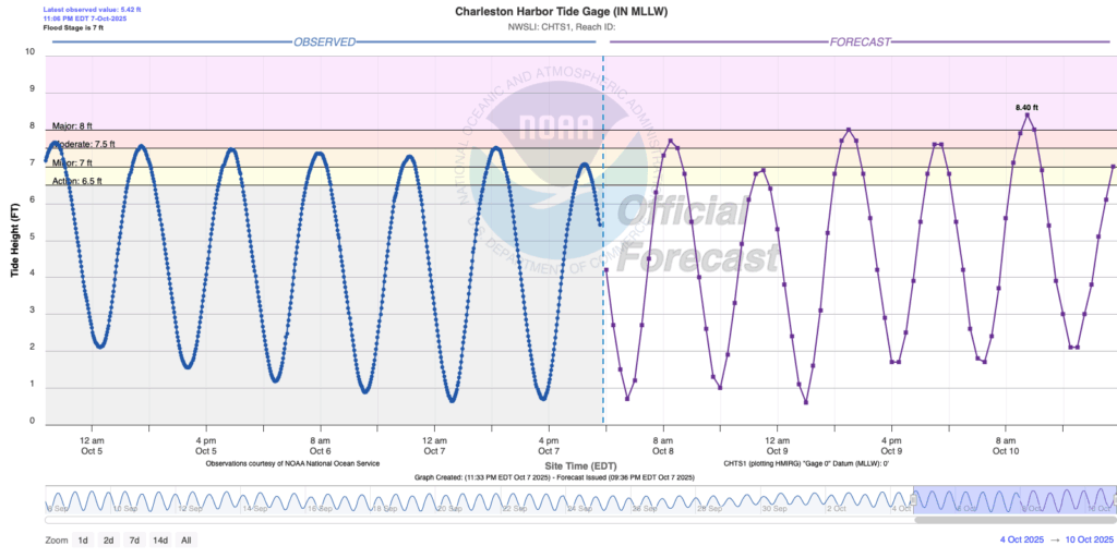
The stiffening northeasterly winds and residual astronomical influences from the full moon and perigee will drive even higher water levels for the second half of the week, with the threat for coastal flooding persisting with each high tide. Daytime high tides will run the highest, though, with major flooding possible from 8 AM-noon Thursday and 8 AM-2PM Friday. Friday could feature the highest tide so far this year, with the water level forecast up to 8.4′ MLLW around 11am. This could cause somewhat widespread traffic trouble throughout downtown Charleston during these tide cycles, so be ready for delays and closed roads as a result.
Follow my Charleston Weather updates on Mastodon, Bluesky, Instagram, Facebook, or directly in a feed reader. Do you like what you see here? Please consider supporting my independent, hype-averse weather journalism and become a supporter on Patreon for a broader look at all things #chswx!