Friday & the weekend: Wind and rain with major coastal flooding Friday & Saturday
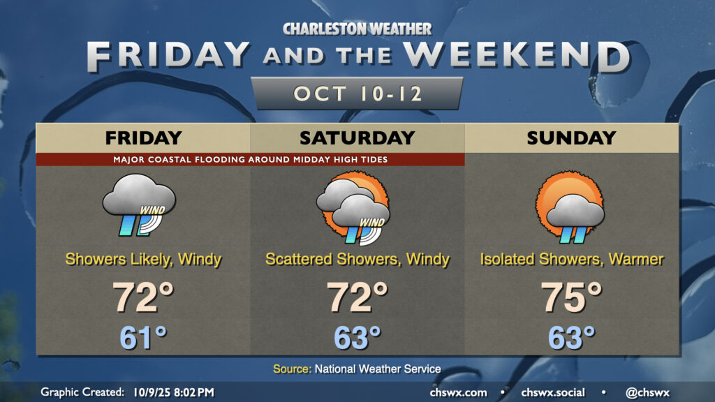
A non-tropical storm system spinning up offshore will bring wind and rain to the area along with major coastal flooding with the midday high tides Friday and Saturday. We’ll start to see some improvements Sunday, thankfully.
Coastal flooding threat peaks Friday
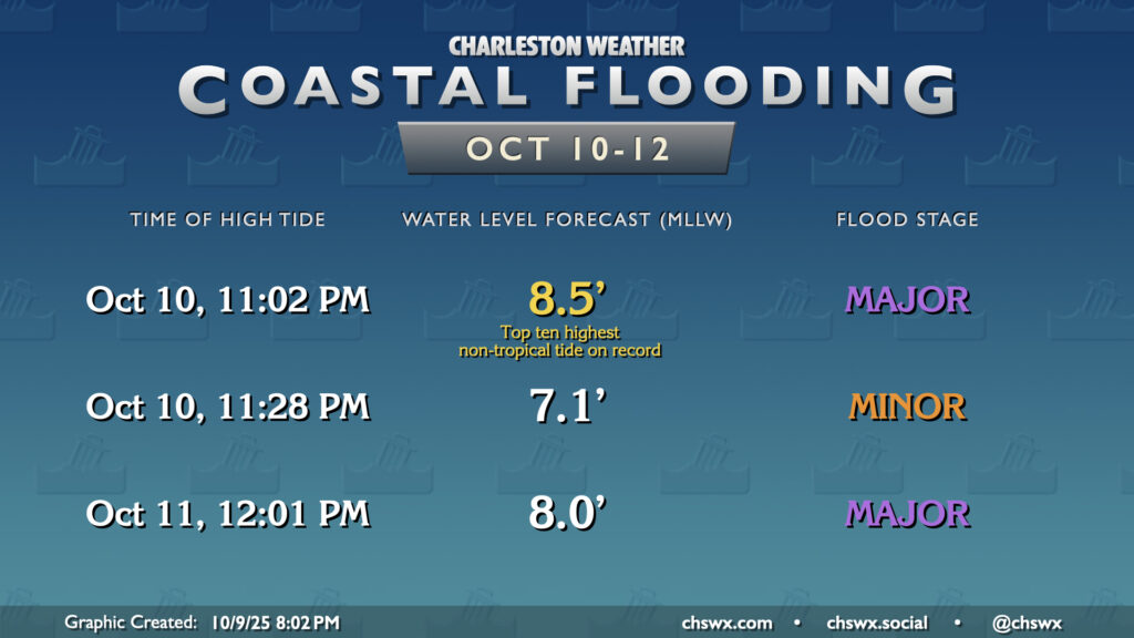
First, though, we should talk about the coastal flooding threat. If the forecast holds, we can expect the highest tide we’ve seen since December 17, 2023 when the water level peaked around 9.86′ MLLW courtesy of another non-tropical coastal storm, which ended up being the highest non-tropical tide on record. While we shouldn’t reprise those heights, 8.4-8.6′ MLLW is nothing to shake a stick at, and would be within the top ten of highest non-tropical tides on record. Expect numerous road closures downtown — especially if rain is in the area — as pumping will be essentially useless due to such high water levels. There will also be coastal flooding impacts on parts of James and Johns Islands, along Long Point Rd. in Mt. Pleasant, and on Daniel Island. Roads close for a reason — never go around barricades that are put in place for your safety, and in general, never drive through a flooded road (especially since this will all be salt water!)
Another minor round of coastal flooding will take place a little before midnight Friday before another very high tide (7.9-8.1′ MLLW) midday Saturday, which should once again flirt with major coastal flood stage. It’s not clear if that will be achieved, though — see how things go on Friday. A minor to moderate coastal flood threat continues on Sunday, but will be trending downward as the nor’easter lifts away and winds finally start to calm down.
Wind and rain Friday and Saturday, improving Sunday
A chill will remain in the air as cooler air draws southward between high pressure to the north and the developing low offshore; expect lows in the low 60s on Friday to warm to the low 70s at best in the afternoon with shower chances increasing especially as we get into the evening. Winds will be very gusty, with gusts 30-35 MPH possible especially at the beaches as well as on bridges and overpasses.
Shower chances with maybe a rumble of thunder and stiff northeast winds will continue Saturday. Temperatures once again start in the low 60s, warming to about the low 70s in the afternoon. There’s a chance we could see a few more breaks in the clouds as we approach Saturday evening, but it still looks like a bit of an icky day for the majority of it.
We’ll see more marked improvements Sunday as the low pulls away. Temperatures will run a few degrees warmer in the afternoon with a little more sunshine, though a residual shower or two can’t be ruled out. Winds will be backing off as well, making for a bit more of a pleasant day. This will set up a quiet stretch starting Monday featuring seasonably warm highs around 80° each afternoon with low humidity.
Follow my Charleston Weather updates on Mastodon, Bluesky, Instagram, Facebook, or directly in a feed reader. Do you like what you see here? Please consider supporting my independent, hype-averse weather journalism and become a supporter on Patreon for a broader look at all things #chswx!