Weekend forecast: Sunny Saturday, a few showers later Sunday
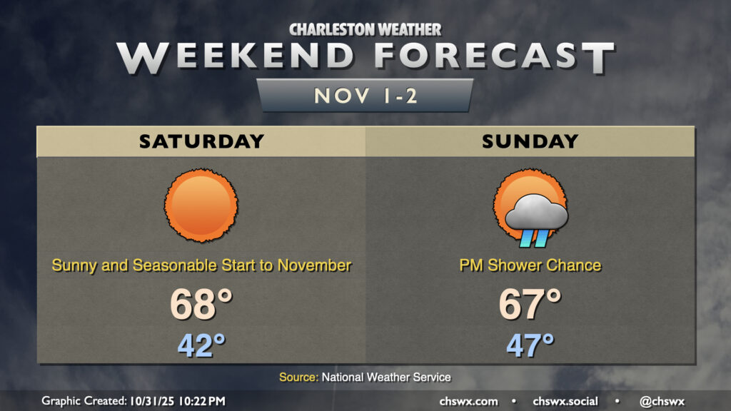
November will get off to a sunny and somewhat chilly start as lows head into the low 40s for the first time since late March with clear skies and calmer winds letting things cool off a little more than Thursday night. We’ll then warm to the upper 60s in the afternoon with plenty of sunshine to be had as high pressure slides overhead.
We’ll start to see a bit more in the way of cloud cover building in overnight, with Sunday morning starting out a little warmer — generally in the mid-to-upper 40s. Cloud cover will continue to thicken as the day goes on, with low pressure starting to spin up somewhere off the Carolina coast that could start to send some showers our way in the afternoon, with better rain chances in the evening through the overnight as the low strengthens. How far up the coast the low spins up will be a big driver in just how much rain falls. Guidance strongly suggests that the low will form off the North Carolina coast, which keeps rain totals generally around or below a half-inch. If the low spins up further south, we could be in for much more rain, but that scenario seems unlikely at this point. We’ll keep an eye on this, just in case. Otherwise, enjoy your weekend!
Follow my Charleston Weather updates on Mastodon, Bluesky, Instagram, Facebook, or directly in a feed reader. Do you like what you see here? Please consider supporting my independent, hype-averse weather journalism and become a supporter on Patreon for a broader look at all things #chswx!