The week ahead: A short-lived shot of winter brings about the first freeze of the season
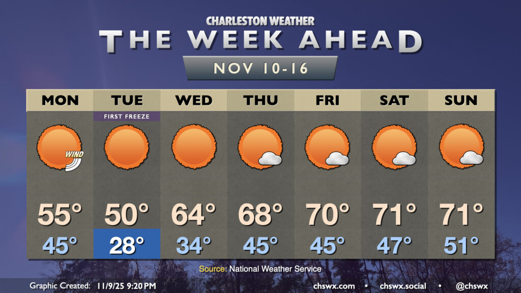
A strong cold front will bring about the first freeze of the season overnight Monday into Tuesday as a highly anomalous intrusion of Arctic air pushes southward. The winter preview will be short-lived, thankfully, but it will be impactful as the growing season almost certainly will end Tuesday morning.
Monday gets off to a windy and chilly start across the area in the wake of the front. Temperatures start in the mid-40s, but will struggle to the mid-50s as colder air continues to work into the area despite sunny skies. Winds kick up in the afternoon into the evening, with gusts pushing 30 MPH at times, and this’ll make things feel much cooler as a result. By Tuesday morning, air temperatures will fall into the mid-to-upper 20s across much of the area, with freezing temperatures getting close to the coast. Wind chills will fall into the low 20s, so be sure you layer up on Tuesday morning as you head out to work, school, or wherever else your travels take you. Highs on Tuesday will struggle to 50°, and it’s conceivable that some of us may not even breach that. The last time highs failed to breach 50° was February 11 of this year, when the high at the airport climate site was 48°.
After another very chilly start Wednesday morning, perhaps with another round of freezing temperatures further inland, we’ll start to see temperatures moderate as high pressure moves overhead. Highs on Wednesday peak in the mid-60s — nearly 15° warmer than Tuesday — and will continue to warm closer to November normals as we head into the weekend, with highs peaking around 70° each afternoon starting Friday. Lows will generally run around if not slightly below normal through Saturday. Higher dewpoints will start to move in Saturday, and that’ll make for a slightly warmer start to Sunday. Rain-free conditions should continue through sunset Sunday before the next storm system affects the area on Monday.
Follow my Charleston Weather updates on Mastodon, Bluesky, Instagram, Facebook, or directly in a feed reader. Do you like what you see here? Please consider supporting my independent, hype-averse weather journalism and become a supporter on Patreon for a broader look at all things #chswx!