The week ahead: Temperatures generally below normal with some much-needed rain in store
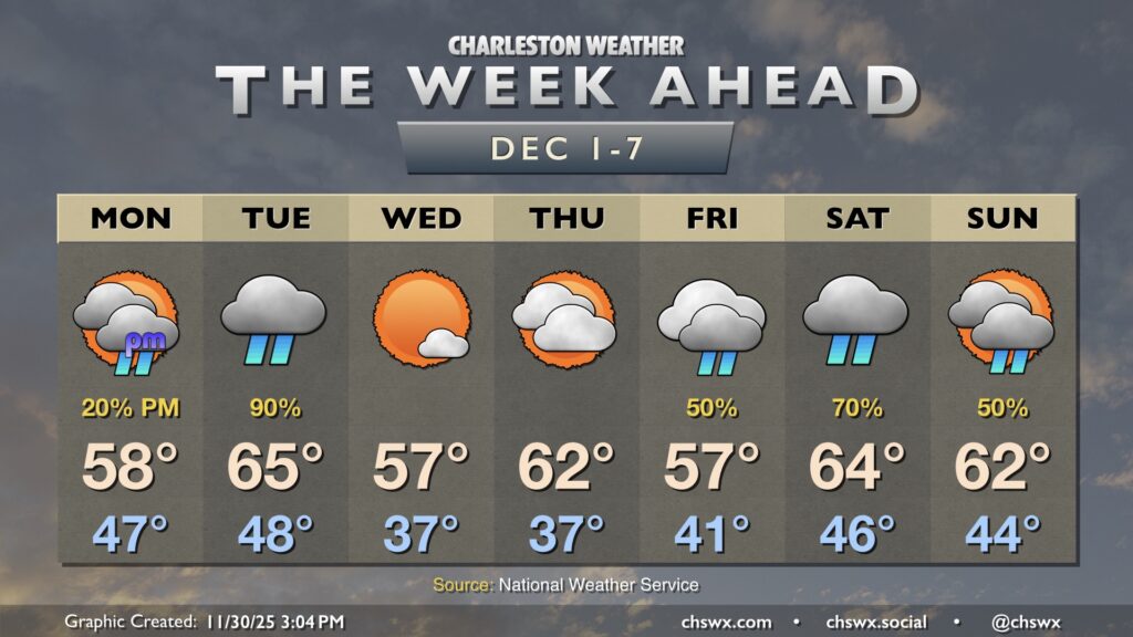
Much-needed rain and below-normal temperatures are in store for the week ahead as a series of fronts affect the area. We’ll also see the risk for some tidal flooding in the mornings beginning Tuesday courtesy of the upcoming full moon.
We’ll start Monday on the dry but cloudy side as high pressure briefly wedges in from the north. Temperatures will run well on the cool side of normal to start December, with lows in the mid-40s warming to just the upper 50s in the afternoon. Some drizzle may be possible, but shower chances will increase generally after sunset as the first front approaches.
The bulk of the rain looks to fall overnight Monday into Tuesday morning. We should see the high pressure wedge weaken as the parent high shifts offshore, allowing a warm front to nudge northward and scour out the wedge. This will, in turn, allow temperatures to jump into the mid-60s in the afternoon, though shower chances will persist into the evening.
Wednesday and Thursday should be quiet and cooler days, with lows in the mid-to-upper 30s and highs in the upper 50s on Wednesday and low 60s on Thursday. The next storm system arrives later Friday, with a stalled front potentially helping to keep some unsettled weather around into the weekend.
Coastal flooding risk returns Tuesday morning
The upcoming full moon on Thursday, which will once again be a “super” moon as it makes its closest approach to earth on its orbit (perigee), will bring the risk for coastal flooding back to the area with the morning high tides beginning Tuesday. So far, the risk seems to be limited to generally minor flooding. We will likely see tidal flooding issues each morning heading into the weekend, so be ready to reroute around a few road closures especially as we get later in the week when those tides will be occurring closer to commute times.