The week ahead: The sun eventually returns as the temperature rollercoaster rolls on
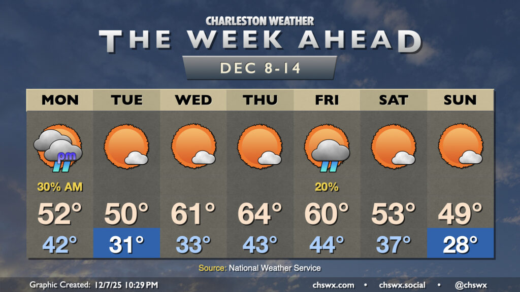
After a rare dreary weekend, the sun will slowly return to our skies on Monday — generally in fits and starts, with some overcast periods in there as well — before more doggedly reasserting itself on Tuesday as high pressure builds in behind a dry front. After another front and maybe a few showers Friday, temperatures look to plunge for the weekend.
First, though, we’ll still be dealing with some lingering showers on Monday as the front to our south remains stalled out and some moisture continues to overrun the area. Temperatures will start in the low 40s once again (somewhat insulated by the cloud cover) before warming to just the low 50s in the afternoon despite some peeks of sun at times. A dry front moves by later Monday, and by Tuesday, we’re starting much cooler, with subfreezing temperatures likely away from the immediate coast. Sunshine will increase throughout the day, but highs will only peak around 50° in the afternoon with cold air moving in from the north. High pressure quickly shifts eastward, though, and a warming trend commences for Wednesday and Thursday. Wednesday starts chilly, but warms to the low 60s in the afternoon; Thursday starts in the low-to-mid-40s and warms to the mid-60s in the afternoon with plenty of sun both days.
The next front looks poised to arrive Friday, and with it comes another round of showers. Lows in the mid-40s warm to about 60° with isolated to scattered showers possible Friday afternoon. There’s model disagreement heading into the weekend, but the going NWS forecast right now points to another shot of cold air working into the area, with highs in the low 50s Saturday and perhaps not getting out of the 40s on Sunday, which may start in the upper 20s in the wake of a reinforcing shot of cold air. Overall, it’s definitely feeling like December as we count down toward the remainder of the holiday season and the end of the year (!!!).
Follow my Charleston Weather updates on Mastodon, Bluesky, Instagram, Facebook, or directly in a feed reader. Do you like what you see here? Please consider supporting my independent, hype-averse weather journalism and become a supporter on Patreon for a broader look at all things #chswx!