Weekend forecast: Saturday’s warmth gives way to an Arctic blast
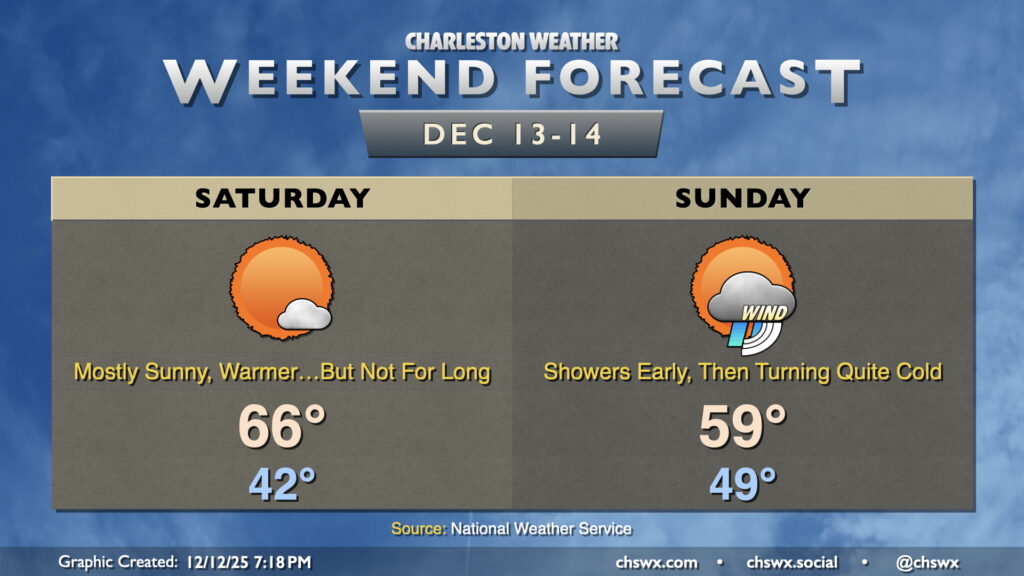
My advice to folks for this weekend: get out and about Saturday as much as you can, soaking in what passes for warmth during this rather chilly December, because another shot of very cold air is enroute to start the new week.
Saturday starts in the low-to-mid-40s, warmest near the coast. Southwesterly flow around high pressure to our east will help drive temperatures into the mid-to-upper 60s in the afternoon with just a few clouds at times. It’s going to be a pretty nice day, so get out and enjoy it!
The front arrives Sunday. A few showers are possible out ahead of the front, but many of us may stay rain-free. The front itself passes through around midday or so, and we should see temperatures begin to fall off in the afternoon. We’ll peak in the upper 50s to around 60° relatively early in the day as a result. Once the sun goes down, temperatures will plummet below freezing by midnight and will continue to fall heading into Monday morning.
Extreme Cold Watch Sunday night into Monday morning: What this means
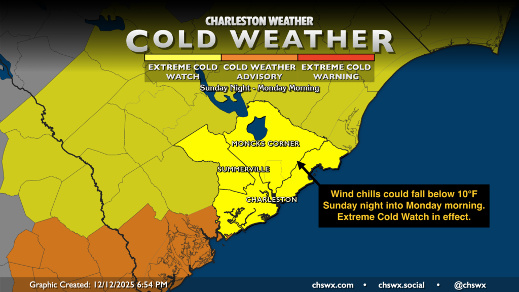
The National Weather Service has issued an Extreme Cold Watch for Sunday night through Monday morning for the entire Tri-County area. Further south, a Cold Weather Advisory is in effect. What does all this mean, though? For NWS Charleston’s forecast area, a Cold Weather Advisory is issued when temperatures or wind chills are expected to fall between 11°-20°F. Anything below that is considered “extreme cold” for this region. With wind chills at 10° or lower certainly possible by Monday morning as winds remain elevated in the wake of the front, it certainly is in the realm of possibility that we achieve that extreme cold criteria, thus the Extreme Cold Watch. If confidence improves in wind chills at 10° or below, the Watch will be upgraded to an Extreme Cold Warning; otherwise, we are almost certainly getting an upgrade to a Cold Weather Advisory.
That’s a lot of phrasing to say that it’s going to be pipe-busting cold Sunday night into Monday morning as air temperatures fall into the teens away from the coast (where it will only fall into the mid-20s). You’ll want to make sure you’ve got a warm place for your pets, a faucet is dripping to keep your pipes flowing, your plants are covered and brought in, and the people in your life are warm and safe — especially those who are most vulnerable to extreme cold.
Looking ahead: Still cold on Tuesday, but warming back up for the second half of the week
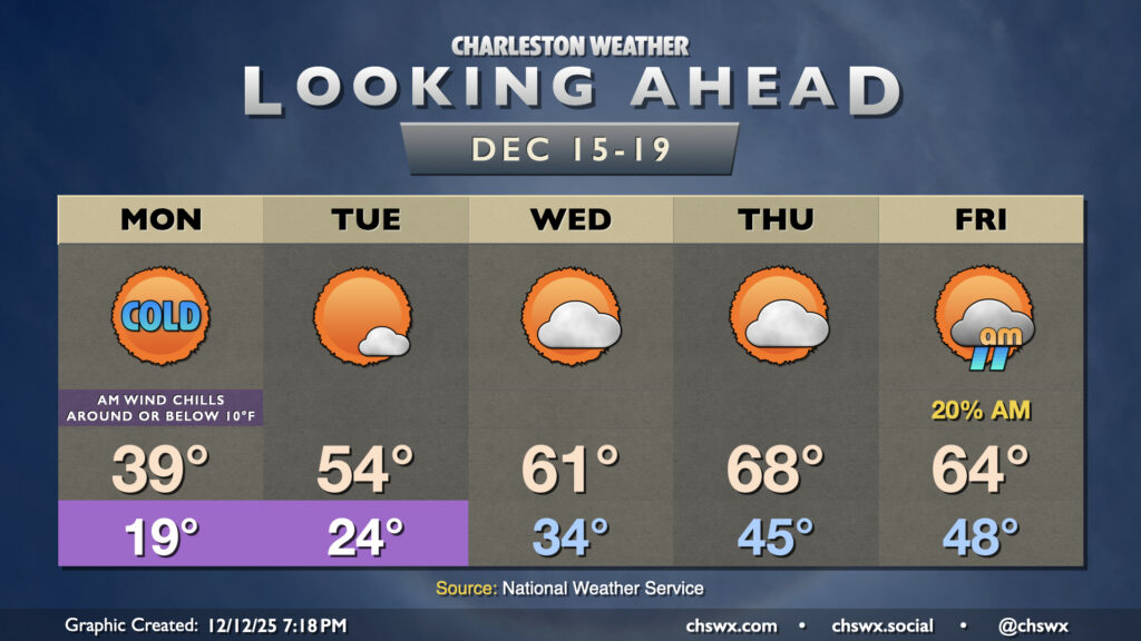
We’ve got another very chilly morning on Tuesday as low temperatures fall to the mid-20s under fairly good radiational cooling conditions. A little bit of wind could yet drive the wind chill down below 20°, which would prompt another Cold Weather Advisory, but we’ll cross that bridge when we get there. Fortunately, the Arctic chill begins to move out as highs Tuesday rise into the mid-50s. 60s look to return on Wednesday, and we could flirt with 70° on Thursday before a (thankfully weaker) front moves by Friday with a few showers and temperatures peaking in the mid-60s.
Follow my Charleston Weather updates on Mastodon, Bluesky, Instagram, Facebook, or directly in a feed reader. Do you like what you see here? Please consider supporting my independent, hype-averse weather journalism and become a supporter on Patreon for a broader look at all things #chswx!