The week ahead: Bitter cold to start, but 60s return by midweek
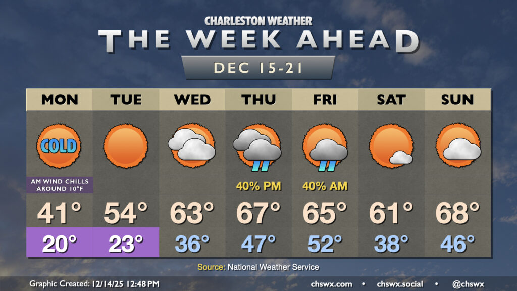
The well-advertised cold snap is underway as Arctic air pushes into the area, with air temperatures expected to fall to around 20° in the morning. While the most gusty winds should subside overnight, a 10-15 MPH breeze out of the north will continue to drive wind chills down well into the teens, with the potential for some brief sub-10° readings as well. A Cold Weather Advisory will run until 10am Monday to cover the most bitter cold, but it will still be a very chilly day with highs struggling to break 40° under mostly sunny skies. Winds will be slackening a little throughout the day, but still should be elevated enough to make it feel more like the mid-30s. Layer up and ensure pets, pipes, plants, and people are protected.
Temperatures will quickly fall below freezing after sunset Monday, and we’ll wake back up in the 20s on Tuesday morning. Winds will be much less of an issue Tuesday, but another hard freeze is expected, so cold weather safety precautions will once again be needed. However, the Arctic high will begin to shift eastward, and we’ll see winds shift around from the west to the southwest during the day Tuesday, which will allow temperatures to moderate a little bit into the low 50s in the afternoon (still well below mid-December norms).
Cloud cover ticks back up on Wednesday, but so do temperatures. Most of us start the day in the mid-30s and warm to the low 60s in the afternoon. A weakening front approaches Thursday, with the specter of a few showers out ahead of it, but the airmass behind it is not remotely close to as cold as tonight’s. Temperatures peak Thursday into Friday, with highs in the mid-60s expected before a brief cooldown Saturday. By Sunday, temperatures look to rebound to near 70° as the next front approaches. Right now, things look generally quiet for the weekend, though there is some model disagreement, so it’ll be worth monitoring updates throughout this last full shopping week before Christmas.
Follow my Charleston Weather updates on Mastodon, Bluesky, Instagram, Facebook, or directly in a feed reader. Do you like what you see here? Please consider supporting my independent, hype-averse weather journalism and become a supporter on Patreon for a broader look at all things #chswx!