Friday & the weekend: Temperature rollercoaster resumes
I hope everyone celebrating had a very Merry Christmas! It was certainly a warm one as the high reached 78° today, just two degrees off the record of 80° last set in 2015 and cementing itself ahead of Christmas 2016 for the second-warmest Christmas high temperature on record at the airport.
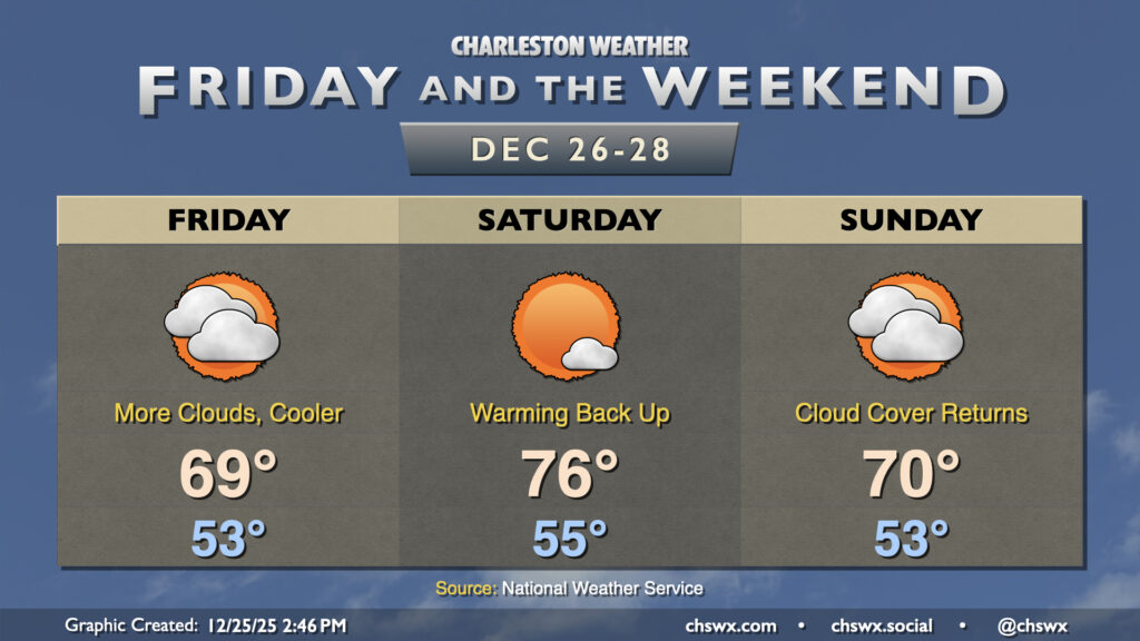
A backdoor cold front stalling nearby will drive more cloud cover into the area for Friday as well as a bit more in the way of onshore flow, which will make for a cooler day (though temperatures will remain above normal). Lows in the low-to-mid-50s will warm to the upper 60s to around 70°. Model guidance keeps the core of the cold air damming regime to the north of the area, but some spots further north in the Tri-County could see temperatures come in a little cooler than that depending on how far south the front penetrates.
Temperatures will swing right back upward Saturday as a storm system moving across the Great Lakes draws the front back to the north. Temperatures start in the mid-50s and will warm back into the mid-to-upper 70s, perhaps threatening the record of 78° set in 2021. Another front then sags back to the south on Sunday as high pressure builds back in across the Northeast, which should once again increase cloud cover and send temperatures a few degrees cooler than what’s expected on Saturday.
As we look ahead to the final days of 2025 and the start of 2026 (unbelievable, really), temperatures will take a tumble back below normal in the wake of a cold front on Monday, with some subfreezing lows and highs in the 50s expected starting Tuesday. Extreme cold is not expected, though. As for rainfall, the forecast is overwhelmingly dry, though the global models are squeezing out some shower activity ahead of Monday’s front. We’ll see how that evolves, but for now, don’t count on much, if any, precipitation over the next week.
Follow my Charleston Weather updates on Mastodon, Bluesky, Instagram, Facebook, or directly in a feed reader. Do you like what you see here? Please consider supporting my independent, hype-averse weather journalism and become a supporter on Patreon for a broader look at all things #chswx!