Weekend forecast: Record warmth possible Saturday, cooler Sunday
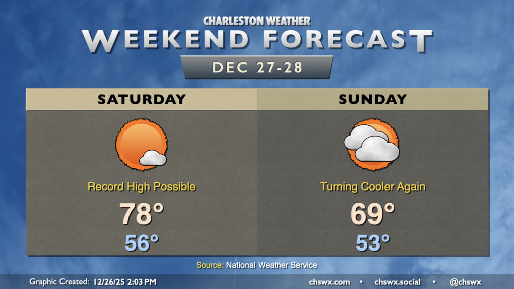
Quiet weather continues this weekend, though the temperature rollercoaster will continue to roll on as record highs Saturday yield to cooler (but still warmer-than-normal) temperatures on Sunday.
Saturday
The wedge front which has kept temperatures pinned to around 70° or so on Friday will lift northward as a warm front later tonight as low pressure moves across the Ohio Valley. This will get our Saturday off to a rather mild start for this time of year, with lows in the mid-50s expected across much of the area. Plentiful sunshine will send temperatures up to the upper 70s to around 80°, especially further inland where the seabreeze will move through later. The record high for December 27 at the airport is 78°, and the current NWS forecast indicates we will at least tie that record. Closer to the coast, temperatures will run a few degrees cooler due to mid-50s water temperatures, but it’ll remain unseasonably warm.
Sunday
The Ohio Valley storm system lifts away later Saturday, allowing high pressure to build back in to our north. This will drive another cold front back across the area late Saturday into early Sunday, and the resulting turn of winds toward the east will cap highs in the upper 60s to around 70° with a mix of sun and clouds. It’ll still be a dry frontal passage, though, with no rain expected.
Looking ahead: Turning cooler to close out 2025
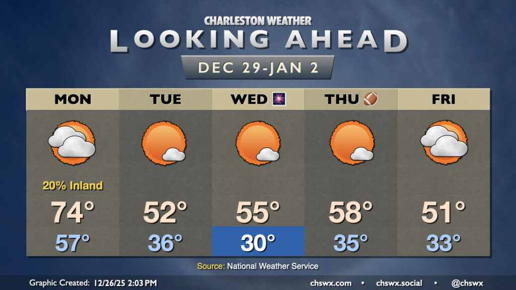
Changes are in the offing, though, as the pattern changes to close out 2025. Aloft, a strong piece of energy will erode the ridge of high pressure that’s been helping to bring us the anomalously warm weather of the past week-plus, and will drive a cold front across the eastern US. This front approaches the area on Monday, bringing with it an uptick in cloud cover and maybe even some showers, especially further inland. It’ll be the last day in the 70s before much cooler air moves in behind the front. We’ll also deal with some breezy conditions, with gusts 20-25 MPH possible ahead of the front.
Tuesday will start much cooler — think lows in the mid-30s in the metro area — warming to just the low 50s in the afternoon despite plenty of sunshine. Wednesday morning gets off to an even colder start, with subfreezing temperatures expected away from the coast before warming back to the mid-50s in the afternoon. You’ll want a jacket of some sort if you’re headed out for New Year’s celebrations as temperatures should fall well into the 40s and even the upper 30s by midnight. Temperatures moderate a bit more on Thursday, with upper 50s to start 2026, but another front will reinforce the cooler air for Friday.
Follow my Charleston Weather updates on Mastodon, Bluesky, Instagram, Facebook, or directly in a feed reader. Do you like what you see here? Please consider supporting my independent, hype-averse weather journalism and become a supporter on Patreon for a broader look at all things #chswx!