The week ahead: Cooling back off to close 2025
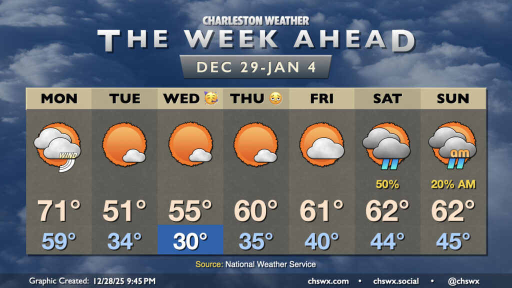
One more unseasonably warm day is on tap for Monday before the airmass flips, which will help us usher in 2026 on a cooler and more seasonable note.
As expected, Sunday was much cooler than Saturday as high pressure wedging southward drove a front through the area. Highs on Sunday only peaked in the mid-to-upper 60s, versus the record high of 79° set on Saturday. That front will lift back northward tonight as a warm front, and we will be back in the warm sector for Monday ahead of a cold front. Temperatures will start in the upper 50s to near 60°, warming to the low 70s under mostly cloudy skies. Southwest winds will pick up ahead of the front, and we could see gusts 25-30 MPH at times as we get into the afternoon. There’s a small chance we may see a few showers from roughly midday to 4PM, but those showers will be on a weakening trend and it’s just as plausible we may not see any rain at all. The front will clear the area during the late afternoon/early evening hours, and winds will go northwesterly in response. By Tuesday, we’re waking up much cooler — lows should bottom out in the mid-30s away from the coast, while temperatures could even touch freezing further inland and in more sheltered areas. Breezy northwesterly winds will drive wind chills into the upper 20s during the morning hours. Highs will struggle into the low 50s despite plenty of sunshine as the core of the cold air swings through.
New Year’s Eve could start around or a little below the freezing mark across much of the area away from the coast. Temperatures will run a couple degrees warmer Wednesday afternoon with plenty of sunshine, but we’ll still only top out in the mid-50s. You’ll want to dress warmly for any New Year’s Eve festivities as temperatures will fall into the low 40s by midnight across much of the area away from bodies of water, but no rain is expected.
Temperatures continue to moderate as we kick off 2026. Thursday’s lows bottom out only in the mid-30s, and we’ll warm to about 60° in the afternoon, right in line with climatological normals for New Year’s Day with plenty of sunshine expected. We will start to see cloud cover tick up on Friday as a cold front sags south and stalls out, with the first rain chances of the new year arriving Saturday as surface low pressure develops and moves along the front toward the Carolinas.
Follow my Charleston Weather updates on Mastodon, Bluesky, Instagram, Facebook, or directly in a feed reader. Do you like what you see here? Please consider supporting my independent, hype-averse weather journalism and become a supporter on Patreon for a broader look at all things #chswx!