The week ahead: Feeling much more like January
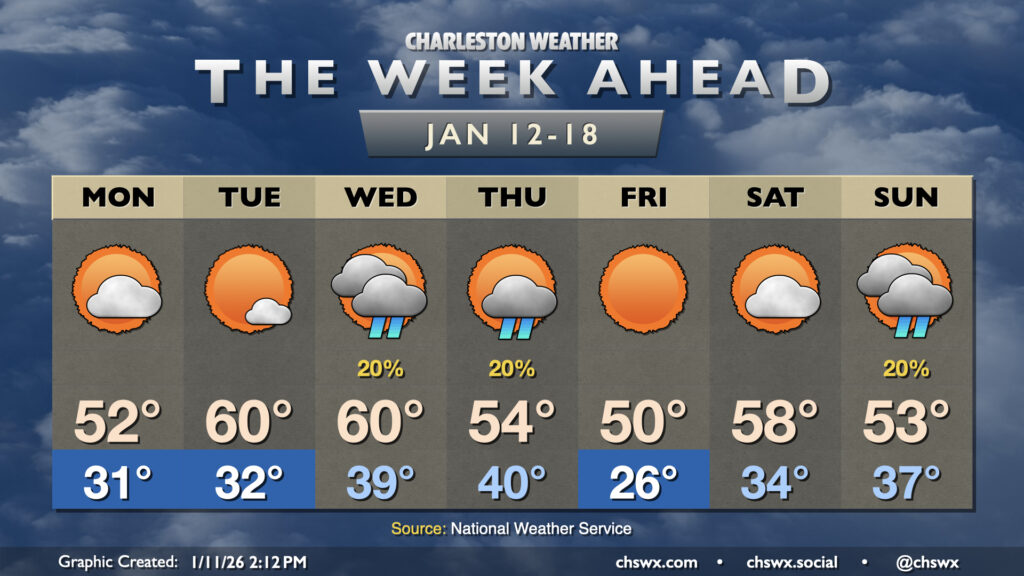
This week will have a much different (and more seasonally-appropriate) feel than last week did as multiple shots of cold air are queued up for our neck of the woods.
Monday starts much colder than we’ve started in over a week, with subfreezing temperatures expected away from the immediate coast by morning. Winds will remain elevated and perhaps a bit gusty, and this will drive wind chills down into the mid-20s. The ongoing cold advection with a mix of sun and clouds will keep high temperatures suppressed to the low 50s in the afternoon, though winds will be slackening as the day goes on, which will at least take the edge off the wind chill.
We’re headed back to around freezing on Tuesday morning, but the airmass moderates a little bit and highs head to around 60° in the afternoon, right in line with mid-January normals. Wednesday starts around 40° and warms back to around 60°, but with a slight chance of a few showers as a front gets through the area. This front cools us off a little bit for Thursday (and might sprinkle a shower or two in along with it), but a stronger shot of cold air awaits later Thursday and will be really felt on Friday as lows plummet to the mid-20s away from the coast. Highs Friday will struggle to 50° despite full sunshine. The more bitter cold is short-lived, though, as temperatures rebound (albeit remaining a few degrees below normal) for Saturday before another slight shower chance on Sunday with another front.
Follow my Charleston Weather updates on Mastodon, Bluesky, Instagram, Facebook, or directly in a feed reader. Do you like what you see here? Please consider supporting my independent, hype-averse weather journalism and become a supporter on Patreon for a broader look at all things #chswx!