Friday & the weekend: Topsy-turvy temperatures with showers and perhaps a few flakes inland on Sunday
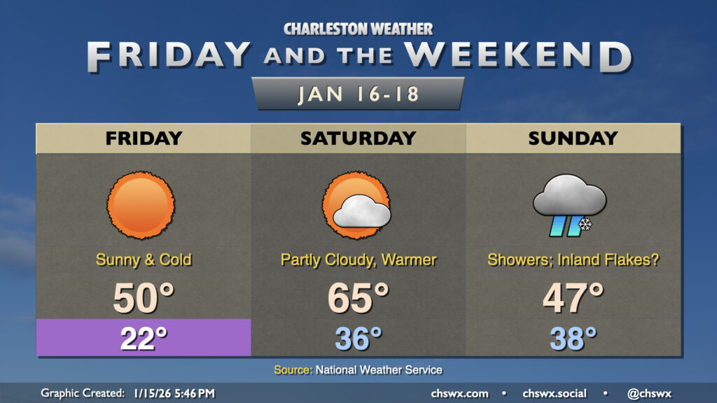
A very cold night is on tap tonight as high pressure settles in across the area, bringing winds down but also helping to create ideal radiational cooling conditions that will send lows to the low 20s across much of the metro by Friday morning, with 20s even reaching the beaches. Further inland, we could see temperatures dip into the upper teens. A Cold Weather Advisory is in effect for Berkeley and Dorchester counties where the most chilly conditions are expected. This’ll be pipe-busting cold so make sure you’ve got a faucet dripping, plants are covered, pets are inside and warm, and the vulnerable people in your life are accounted for and safe.
High pressure moves overhead and starts to head offshore on Friday. This will allow temperatures to head to about 50° in the afternoon with full sunshine; still well below normal but a touch warmer than the high of 49° recorded at the airport today. The high slipping offshore will allow for winds to go back around to the south by Saturday morning, and the resulting influx of warmer air will send highs into the mid-60s in the afternoon. The warmth is short-lived, though, as a cold front approaches the area Saturday night and comes through on Sunday.
At a minimum, we’ll see some much-needed rain across the area on Sunday as developing low pressure offshore draws moisture northward as a trough of low pressure aloft swings through. Depending on where the surface and upper lows set up, some of us could see some conversational snowflakes mixing in with the rain. The best chance for this will be found along and inland of 17-A, it looks like, as models have trended a little warmer closer to the coast. Regardless of where you are in the Tri-County, air temperatures at the surface will remain above freezing during the day, and so anything wintry that does fall won’t accumulate. See what happens, but major impacts are not expected regardless. Precipitation departs by evening and sets up a very cold start to Martin Luther King, Jr. Day on Monday.
MLK Day: Sunny, chilly
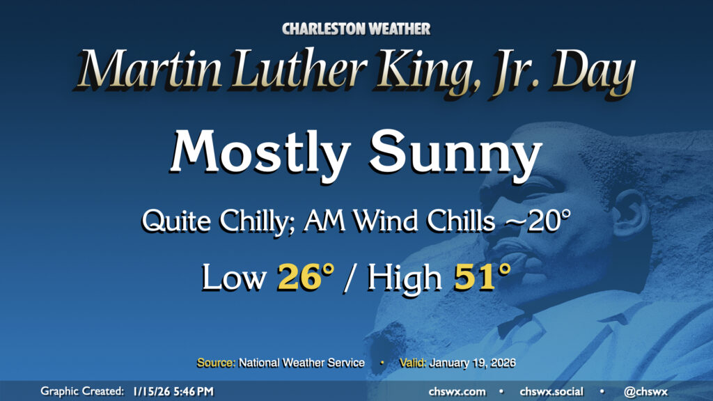
Temperatures on MLK Day fall to the mid-20s away from the locally warmer coastline as the cool and dry airmass sets in. The sunshine will help temperatures get a little above 50°, but don’t expect much more than that. However, there are no other weather concerns for your outdoor remembrances of Dr. King this year, just so long as you have a jacket and whatever else you need to stay warm.
Follow my Charleston Weather updates on Mastodon, Bluesky, Instagram, Facebook, or directly in a feed reader. Do you like what you see here? Please consider supporting my independent, hype-averse weather journalism and become a supporter on Patreon for a broader look at all things #chswx!