Rest of the work week: A couple more chilly mornings before brief warming; watching the weekend closely for winter weather
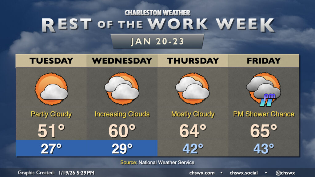
Chilly mornings will continue through Wednesday as another reinforcing shot of cool air moves in overnight Monday into Tuesday. We’ll start Tuesday back in the mid-to-upper 20s, but northwesterly winds around 5 MPH or so could make it feel closer to 20°, so be sure to layer appropriately heading out to work or school. Temperatures will only make it to the low 50s as the influx of cool air continues throughout the day. Expect a scattering of clouds, but still plenty of sunshine.
We’ll have one more chilly start on Wednesday before high pressure slips offshore. Temperatures will moderate to around 60° in the afternoon after starting in the upper 20s with an uptick in cloud cover as a cold front approaches. The cloud cover will keep things comparatively warm overnight, with lows in the low 40s to start Thursday. Despite the frontal passage, temperatures will still trend warmer Thursday into Friday with mid-60s expected each afternoon. A slight shower chance arrives Friday afternoon and evening ahead of the next cold front, which will stir up plenty of winter weather intrigue for the weekend.
Winter weather potential increasing for late weekend/early next week
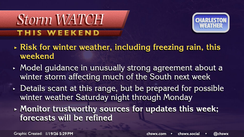
The potential for winter weather is ticking up this weekend as models come into fairly strong alignment with plentiful warm, moist air streaming atop high pressure at the surface that’ll be driving Arctic air well southward, including into the Carolinas. Broadly, past experience teaches us that this kind of setup could mean a round of sleet and/or freezing rain for our neck of the woods over the weekend into early next week, which could be impactful to travel. (It’s very tough to get snow out of these kinds of setups as there is usually a layer of warmer-than-freezing air aloft that melts the snow before it reaches the freezing layer.) There are many outstanding questions that we won’t have a handle on for a bit, including just how far south the Arctic air penetrates, how deep the subfreezing layer beneath the warm conveyor of moisture aloft becomes, and the forward speed of the storm system. There’s still a lot of time for things to come into alignment, so stay tuned to trustworthy sources of weather information as the week progresses as additional data becomes available.
Follow my Charleston Weather updates on Mastodon, Bluesky, Instagram, Facebook, or directly in a feed reader. Do you like what you see here? Please consider supporting my independent, hype-averse weather journalism and become a supporter on Patreon for a broader look at all things #chswx!