Friday & the weekend: Turning chilly and unsettled, but winter weather potential continues to decrease
After a high of 72° on Thursday, we’ll turn progressively cooler heading into the weekend as a large storm system affects much of the southern and Mid-Atlantic states over the next few days. Fortunately, the risk for accumulating ice continues to decrease into oblivion for much of the Charleston metro area.
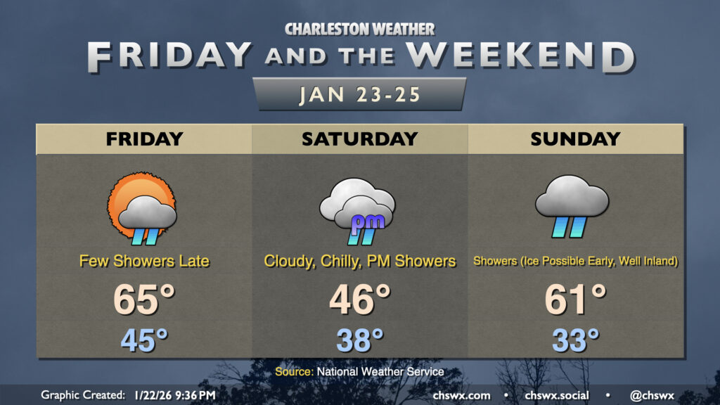
We’ll start Friday on a seasonally mild note, with lows in the mid-40s across the area with a stalling front just to our south. Temperatures will warm to the mid-60s in the afternoon with a mix of sun and clouds. A few showers may be possible later in the day into the evening as a little more moisture moves in from the north and winds aloft overrun the front, but otherwise we should stay mostly dry.
Changes arrive on Saturday as expansive high pressure to the north begins to wedge down the side of the Appalachians along the Eastern Seaboard, spilling much colder air into the area. We’ll start the day in the mid-to-upper 30s, warming to only the mid-40s under predominantly cloudy skies. Moisture will begin to deepen across the area as Saturday goes on, and we should see some periods of showers developing in the afternoon.
The best risk of any freezing precipitation arrives later Saturday evening through Sunday morning. It’s in this period where we’ll want to watch how far south the subfreezing air can penetrate. Right now, the best juxtaposition of cold air and moisture looks to be north of the Charleston metro, with the greatest risk for icing in the Tri-County area to be found along the Santee River west of Jamestown as well as I-95. Ice accretion should be relatively light, though some 0.10″ accumulations are possible, which may cause problems on some bridges and overpasses where icing occurs. This does not, however, get into the range where we start to see widespread power problems (e.g. not February 2014). It isn’t out of the question that some light freezing rain falls as south as places like Moncks Corner and Summerville, but this would be in a worst-case scenario at this point.
Low pressure moving across Alabama and Georgia will drive a warm front northward into the area, placing us in the warm sector of the storm system in the late evening. It may take some time to break down the cold air wedge, but once that happens, temperatures should warm after dark into the upper 50s to around 60° (hence the high of 61° on the graphic). A band of showers and maybe even a thunderstorm will move through late Sunday/very early Monday morning, clearing the area around daybreak. From there, temperatures will chill out quite a bit, kicking off a very chilly week that will likely feature Cold Weather Advisories on Tuesday morning. But hey, at least there won’t be a Ravalanche repeat!
Follow my Charleston Weather updates on Mastodon, Bluesky, Instagram, Facebook, or directly in a feed reader. Do you like what you see here? Please consider supporting my independent, hype-averse weather journalism and become a supporter on Patreon for a broader look at all things #chswx!