Weekend forecast: Storm system arrives with freezing rain inland, cold rain at the coast
A reasonably busy weekend of weather awaits in the Lowcountry as we deal with the south side of a massive and likely potent winter storm, the effects of which are starting to develop across Texas into the Midwest before spreading eastward during the day tomorrow into the Mid-South and eventually to the Eastern Seaboard.
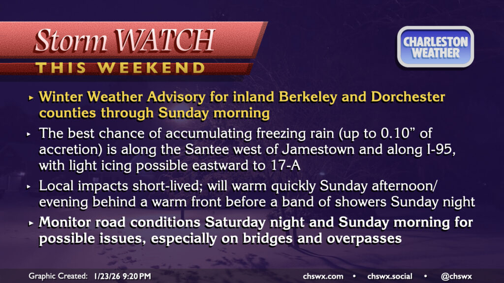
For our part, a Winter Weather Advisory has been hoisted for inland Berkeley and Dorchester counties, with some freezing rain expected between Saturday night and Sunday morning. Elsewhere in the Charleston Tri-County area, we’ll deal with periods of cold rain as well as some windy conditions. Comparatively, though, this will be this storm on easy mode for a lot of us — some really treacherous conditions are likely to develop across the northern half of the state into NC. Read on to learn what’s most likely to happen in your neck of the woods.
Inland Berkeley & Dorchester (Moncks Corner, Summerville, St. George, Lake Moultrie)
Saturday: Chilly & windy with freezing rain possible late
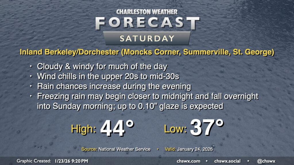
Cloud cover, gusty winds, and chilly temperatures will be the main story for much of the daytime hours on Saturday across the entire Lowcountry. In fact, we will likely get a bulk of the daylight hours in rain-free as the storm system takes its time to get here. High pressure will be wedging in from the north, though, and gusty northeasterly winds will be keeping temperatures pinned to the mid-40s at best during the day, with temperatures falling into the 30s shortly after sunset.
The storm system will arrive in the Carolinas by evening, with the risk of rain arriving after sunset. The Winter Weather Advisory goes into effect at 7PM Saturday for inland Berkeley and Dorchester counties, marking the most likely time for any freezing rain accumulations. The overall expectation for freezing rain is a glaze up to a tenth of an inch on elevated surfaces, potentially including bridges and overpasses, across northern Berkeley and Dorchester.
Sunday: Freezing rain departs, turning warmer ahead of a round of showers and maybe a thunderstorm
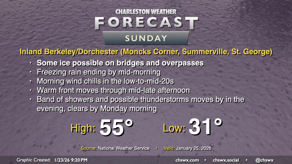
Freezing rain will come to an end by midday Sunday as temperatures begin to warm up a bit, but be alert to slick surfaces during the morning hours due to freezing rain. A warm front will lift across the area during the afternoon into early evening ahead of a band of showers and maybe a few thunderstorms. This band will likely produce the most substantial rainfall from the event, but no further winter weather is expected. The band clears by early Monday morning, with a potent Arctic cold front to follow that will keep us quite cold all next week.
Charleston metro area closer to the coast (Downtown, West Ashley, Mt. Pleasant, North Charleston, Goose Creek, Hanahan)
Saturday: Chilly, windy, with cold rain overnight
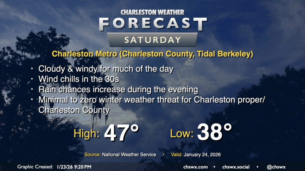
Cloud cover and gusty northeasterly winds will keep things on the chilly side for the rest of the metro area on Saturday, with slightly warmer temperatures closer to the coast courtesy of marine influences. Generally, expect temperatures in the mid-40s for much of Saturday, falling into the 30s late. We should be largely rain-free for much of the day as well with rain chances entering the picture during the evening. Meanwhile, temperatures will be falling well into the 30s overnight. Freezing rain is not expected for now, but a little light accretion on elevated surfaces in sheltered and cooler areas might not be totally out of bounds if temperatures run a couple degrees cooler than currently forecast (which is in the realm of possibility). However, widespread issues are not expected.
Sunday: Chilly morning, turning warmer ahead of showers and maybe thunderstorms late
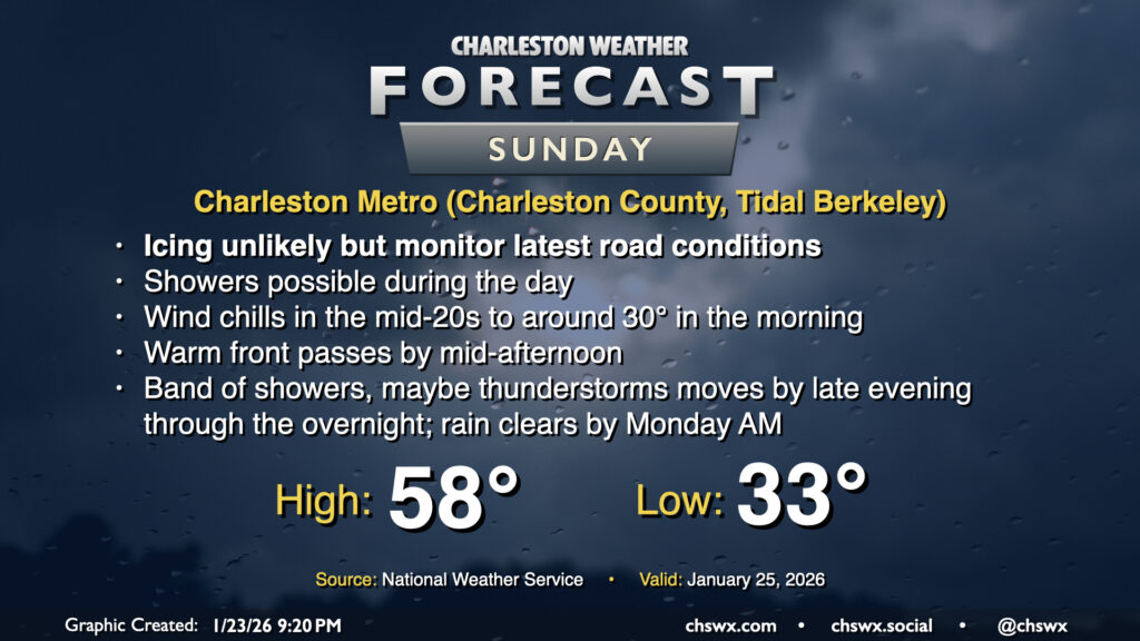
Icing issues aren’t really expected in the Charleston metro, especially along and east of Highway 17, but as mentioned earlier, we’ll be flirting with the freezing mark pretty closely Sunday morning, so some slick spots may not be completely out of the question. These should be short-lived, though, as temperatures head into the mid-to-upper 50s in the afternoon behind a warm front. Showers will be possible during the day, though as the warm front lifts north, we should get into a dry slot before a more substantial band of rain and maybe even a few thunderstorms moves by later Sunday night. This prefrontal band of rain will likely go down as the most substantial precipitation of the event for the Charleston metro, in fact. It’ll clear the area by daybreak Monday, followed by the aforementioned potent Arctic front.
Bottom line: A tricky couple days of weather ahead, but nothing we can’t handle
Yes, we have a couple tricky days of weather ahead with a difficult forecast that could hinge on a degree or two difference, but as far as things go here, it’ll be a reasonably minor scrape compared to what’s looking probable for the Upstate and Midlands into North Carolina. Still, any ice is troublesome for us — we’re just not built for it — so please be safe on the roads, heed any closures, and take extra care on bridges and overpasses, which will freeze first if it comes to that. Stay warm!
Follow my Charleston Weather updates on Mastodon, Bluesky, Instagram, Facebook, or directly in a feed reader. Do you like what you see here? Please consider supporting my independent, hype-averse weather journalism and become a supporter on Patreon for a broader look at all things #chswx!