Friday & the weekend: Briefly warming up before the weekend turns cold and, yes, snowy
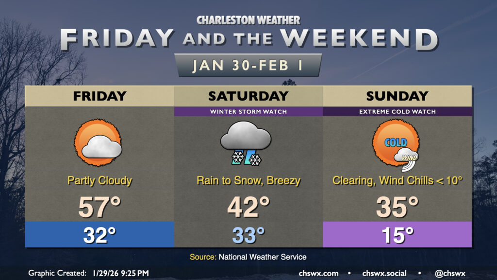
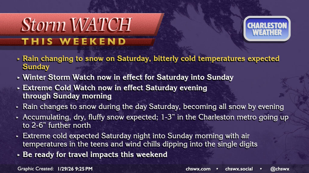
A cold and snowy weekend lies ahead as the storm we in the weather enterprise have been watching closely for the last several days in guidance looks to become a reality for a pretty solid winter weather event for this neck of the woods on Saturday followed by bitterly cold temperatures on Sunday. A Winter Storm Watch and Extreme Cold Watch have been issued by the National Weather Service for much of the weekend, so that’s how you know it’s getting real.
What to expect
We at least get a reasonably “warm” day (comparatively speaking, anyway) on Friday before this latest Arctic invasion takes shape. Temperatures Friday will start around freezing, but should warm well into the mid-to-upper 50s in the afternoon under partly cloudy skies. It’ll be a good day to grab a few things to help get cozy as well as prepare your home for a few days of very cold weather.
Clouds will increase later Friday as low pressure develops well offshore and starts its trek northward. Rain showers could begin as early as midnight, but are more likely to start as we get closer to daybreak Saturday. As the atmospheric column turns colder aloft, we should begin to see rain transition to snow by roughly midday from north to south, though this transition could happen earlier. By evening, we should be in all snow, and that should continue for a few more hours before the low pressure system pulls away. As the low passes, winds will tick upward with gusts pushing 30 MPH at times, which means there’s a risk for some small drifts and blowing snow.
Given the depth of the cold air, high snow-to-liquid ratios are expected. One tool forecasters (including me!) use to analyze atmospheric model data, BUFKIT, suggests the snow-to-liquid ratio for our event could range generally between 12:1-18:1 during the event. So, for every inch of liquid water, that could generate about 12-18″ of snow. (We’re only expecting about a tenth of an inch of liquid-equivalent precipitation, FWIW, so don’t get too freaked out!) What this ultimately means is that the snow will be dry and fluffy as opposed to the wetter, slushier snow we are used to. Climatologically, Charleston snow events tend to yield ratios of about 7:1 or so; the ratios we’re expecting are more akin to what you’d see at a resort in the Rockies. This will ultimately make it more conducive to blowing around with the higher wind gusts which could make travel quite difficult if not dangerous at times, especially overnight Saturday into Sunday. It won’t be a bad idea to make a plan to get hunkered in Saturday evening and be in for the night. Remember, bridges and overpasses tend to freeze first given airflow atop *and* below the road. We have a lot of those here in critical spots, so really try not to travel Saturday evening if you don’t have to, and overall you should be prepared for travel impacts all weekend. If you have flights in or out, check with your airline as snowfall tends to cause at least temporary airport closures around here.
Snowfall will depart with the low pressure system overnight Saturday into Sunday morning. Very cold air will be in place, especially depending on how much snow falls. Overall, we can expect to wake up to air temperatures in the mid-teens across much of the area Sunday morning, with lower 20s near the coast. Lingering breezy winds will drive wind chills into the single-digits for much of Sunday morning, which is very unusual for this neck of the woods. Layer up very carefully if you are headed out; face covers, gloves, and hand warmers will be a good idea.
The snow’s staying power over the following few days will have a lot to do with how much ultimately falls. As we’ve seen in events past, the snowpack can have effects on the temperature forecast. Right now, it’s probable that much of the snow will melt by Monday, but if we get a larger thump, it could take another day or so for it to fully melt. This will also have impacts on the black ice threat each night as temperatures fall below freezing. Suffice it to say, it may be touch and go for a couple days getting into next week. The snow should be gone by midweek, though, with the next rain chance arriving Thursday.
Snowfall forecast and caveats
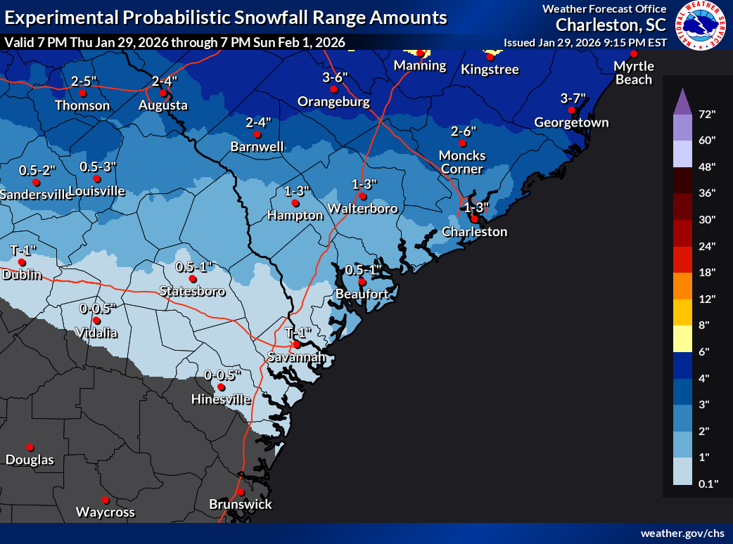
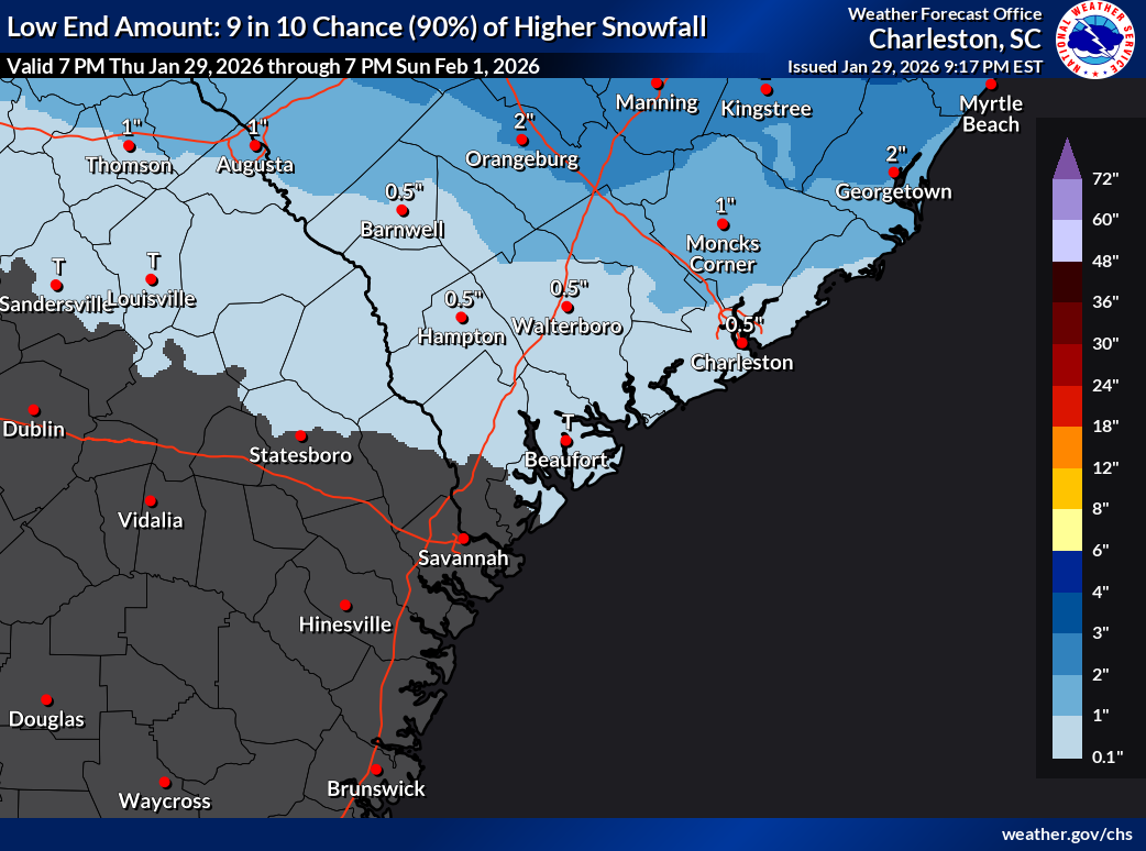
Forecasting snow totals is difficult, much less in the South where marine influences and other factors can really futz with the forecast. The National Weather Service has gone to much more of a probabilistic technique for communicating snowfall forecasts over the past few years, which helps to illustrate the most likely outcomes as well as what could happen if the storm over- or under-performs.
Generally speaking, the NWS forecast is looking for about 1-3″ for Charleston proper, with lower amounts as you get further southwest; those of you on Wadmalaw or Edisto may see a lot less. But yes, we should see snow to the coast. Further north and east, we’ll find the higher snow totals courtesy of closer proximity to the low pressure system; anywhere from 2-6″ of snow will be possible in northern Berkeley, Dorchester, and Charleston counties, with maybe even a bit more from Lake Moultrie to the Santee. The ranges are still a bit wide because there are still a lot of unknowns and small-scale perturbations that could make a big difference in totals. If and where bands of snow set up, for example, snow totals could be higher. And if you aren’t in one of those snow bands, you may end up seeing less snow than you would have if there was no banding at all.
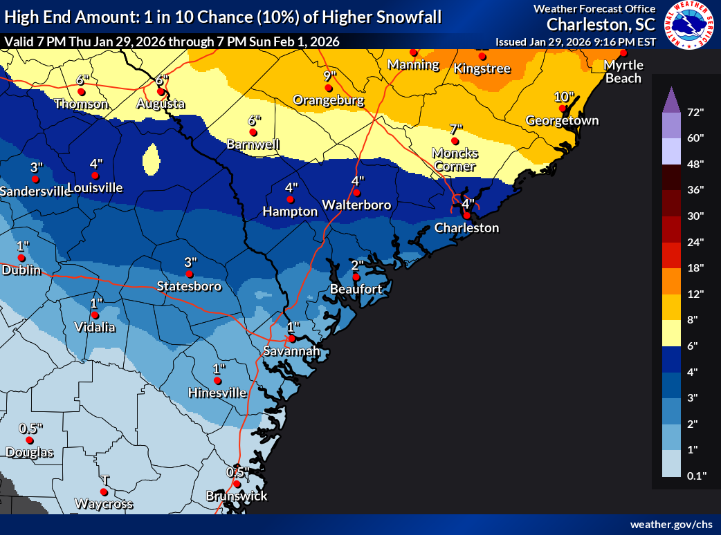
If and where the storm overperforms, snow totals could run as high as 6-8″ north of a Summerville-Goose Creek-Awendaw line, with totals 3-5″ possible over Charleston proper, decreasing as you head south. Conversely, if the storm underperforms — which is still in the realm of possibility — we could see as little as an inch of snow in the northern tier and less than a half-inch further south into Charleston and to the beaches. And yes, there have been some underperformance scenarios in some of the higher-resolution guidance that give me pause on getting my hopes too high for a big bang of snowfall, and I want y’all to make sure your expectations are set appropriately, too.
Comparing to recent past events
This event has a different feel from the past couple snow events we’ve had in the Lowcountry given the depth of the Arctic air in place. We won’t really be contending with precipitation-type issues this go-around, for example. There’s a tiny bit of a warm nose of air just off the deck in model data, which is not uncommon for this part of the world, but it shouldn’t be enough to really cause any icing issues. This is in stark contrast to the 2018 event, which started with a quarter-inch of ice accretion in some places before changing over to snow later in the day. Last year’s event started out with quite a bit of sleet, which put a major dent in storm snow totals that ended up around 2-2.5″ across much of the area. We won’t have the precursor icing event (though roads may still get slick) this go-around, nor should precipitation types really be a problem especially away from the immediate coast. With any luck, this should portend a bit quicker recovery, but we’ll see how things go Saturday.
Finally, a really interesting stat from the National Weather Service in Charleston prompted by a question in the NWS partners chat from Bill Walsh, Live 5 chief meteorologist: The only other time there have been consecutive years with measurable snowfall in Charleston were 1988 and 1989. In 1988, we measured 0.4″; in 1989, we measured 8.9″ of snow (most of that coming with the historic snowstorm of December 22-24). It looks like we’ll tie that streak after Saturday, barring a major, unforeseen change.
Follow my Charleston Weather updates on Mastodon, Bluesky, Instagram, Facebook, or directly in a feed reader. Do you like what you see here? Please consider supporting my independent, hype-averse weather journalism and become a supporter on Patreon for a broader look at all things #chswx!