Weekend forecast: Snowy & cold; record lows possible Sunday
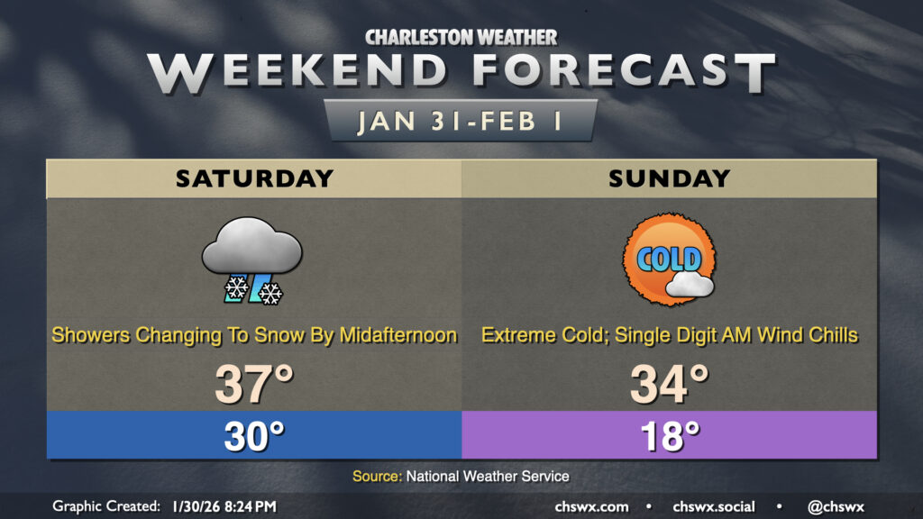
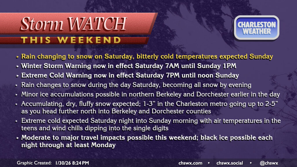
Well, it certainly appears as if the third time will be the charm for snow-lovers in the Lowcountry as a long-anticipated winter storm system impacts the area this weekend. A Winter Storm Warning goes into effect Saturday at 7AM and will run until Sunday at 1PM. Meanwhile, an Extreme Cold Warning will also go into effect Saturday at 7PM until noon Sunday for air temperatures in the mid-to-upper teens and wind chills dropping perhaps as low as 3° above zero in the morning — extraordinarily rare cold air for this part of the world.
What to expect
This evening we are monitoring the developing surface low pressure system offshore and the upper-level energy diving out of the Great Lakes states toward the Carolinas. They’ll hook up on Saturday to bring us a solid winter weather event for the Lowcountry.
Saturday morning should still be rather dry as it will take some time for the atmospheric column to saturate and cool. Temperatures should drop below freezing briefly before slowly warming to the mid-to-upper 30s (at best) by afternoon. There is a risk of some patchy freezing drizzle developing in northern Berkeley and Dorchester counties during the morning and early afternoon hours, but accumulations should be minimal. Still, there will always be some risk for slick spots developing if that should take place.
The main event should begin to unfold after noon for most of us. Some rain showers, especially near the coast, could fire up before a changeover to snow showers as we get into Saturday afternoon. This does mean you may have some time, especially the further south you are, to grab a few more things before the snow kicks in, but this isn’t a guarantee, either.
The bulk of the snow falls Saturday evening as the upper low traverses the area and the surface coastal low makes its closest pass. It’ll also be during this time when winds will kick up some, especially at the coast; gusts to 30 MPH aren’t out of the question there with gales expected in the coastal waters and Charleston Harbor. Given the snow’s dry and fluffy character, it’ll be more prone to being blown around with even some drifts forming. All in all, this should make for treacherous travel Saturday afternoon and evening, and your best bet is to stay hunkered in unless you absolutely must travel. Keep roads free for medical workers and other essential personnel, and don’t be the reason a first responder has to put themselves in harm’s way. Bridge closures and other matters, if necessary, will be announced by local authorities; the meteorological community has no real control over if and when those closures occur. Even if bridges and overpasses are open, they’ll be the first to freeze over, so use extra caution if traveling over them. Same for the airport; if you have a flight coming or going over the weekend, check with your airline on that flight’s status and be as flexible as you can with your travel plans.
Expected snow totals
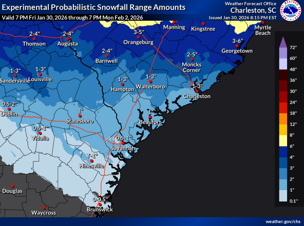
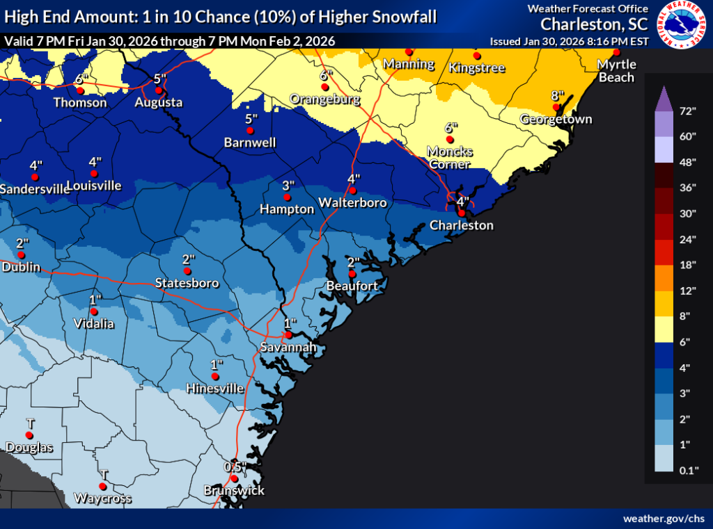
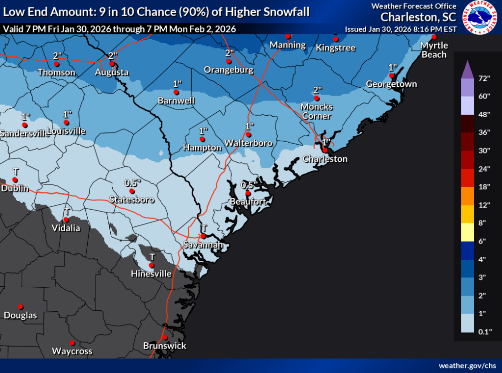
As we would expect, the snowfall ranges have dialed in a little bit better on the extremes over the last day as more model data comes in. Generally speaking, the most likely outcome for snowfall will be 1-3″ over the Charleston metro area and points southward, approaching 2-5″ as you head further north into places like Moncks Corner and Summerville. Further toward the Santee and the I-26/95 interchange, we start to get into the 3-6″ range. Locally higher (and lower) amounts remain possible especially around where snow bands, if any, set up. Dry slots and other factors can still play havoc as the event plays out, so there is still the potential for a little less snow than the ranges depicted above.
Historic cold expected Sunday
An Extreme Cold Warning goes into effect Saturday night through noon Sunday as record low temperatures are expected across the area, with lows in the mid-to-upper teens common away from the immediate coast, which will still dip well into the low 20s. The daily record low of 21° set on February 1, 1977 should easily fall, and wind chills will dip into very rare single-digit-above-zero territory for a few hours Sunday morning. That wind will remain elevated throughout the day Sunday, keeping wind chills pinned to the mid-20s during the peak of the afternoon. Despite full sunshine, the sun’s energy is going to be going into melting the snowpack, and temperatures will struggle to warm much beyond freezing. It’s probable that the record cold high temperature for February 1, 38° set in 1980, will also fall. Suffice it to say: If you head out during the day Sunday, you’re going to want to be bundled up in multiple layers. This cold is nothing to trifle with, especially in this part of the world where we are simply not used to it.
Some snowmelt and compaction should take place Sunday. The melting will refreeze into patches of black ice overnight as temperatures dip once again into the upper teens to low 20s, making for potentially hazardous travel on Monday morning. While turning warmer, temperatures will still dip well into the 20s Monday night into Tuesday morning, so we are likely repeating the exercise for at least one more day. Snow should be mostly gone by Tuesday, and by Wednesday, we are approaching 60° again, albeit with some shower chances.
How to help us tomorrow
We’re going to need your help tomorrow to understand what’s happening on the ground, especially if the Charleston radar — which remains under repair, but is operating as of publishing time — has trouble staying online before and during the event. There are a couple ways to do this:
- mPING, which is an app that you can use to report the precipitation type you’re experiencing in your area. (RadarScope, a popular weather data viewer for mobile devices, also supports sending mPING reports.)
- Good old-fashioned measurements with a snow board and a ruler or yardstick. The CoCoRaHS program has a comprehensive training deck for measuring winter precipitation; while much of it is geared toward observers in the program, there is plenty of information that is widely applicable as good practice for taking accurate measurements.
- Send reports over social media with a location, time, and a photo of your snowfall measurements if possible!
Be safe and enjoy tomorrow’s snow day!
Follow my Charleston Weather updates on Mastodon, Bluesky, Instagram, Facebook, or directly in a feed reader. Do you like what you see here? Please consider supporting my independent, hype-averse weather journalism and become a supporter on Patreon for a broader look at all things #chswx!