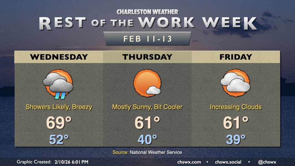
Rest of the work week: Showery Wednesday before turning cooler
We had quite the temperature swing on Tuesday, with a low of 33° giving way to a high of 76° in the afternoon. A warm front that swung through around daybreak helped temperatures jump from 37° a little after 6am to 46° about 20 minutes later, according to the National Weather Service. From there, plenty of sunshine propelled us to the warmest day since January 10.
I hope you got to enjoy the brief spring preview, because the weather will turn more unsettled on Wednesday as a cold front approaches from the northwest. Temperatures will still run well above normal, with lows in the low 50s yielding to highs once again approaching 70° in the afternoon. Showers will begin to move into the area as early as daybreak, with off and on showers possible through the evening hours.
The front itself gets through overnight, and by morning temperatures will be back down to around 40° or so. Cooler and drier air will continue to push in throughout the day, but the airmass change won’t be terribly sharp this go-around as highs peak in the low 60s, just slightly on the cool side of normal for mid-February. We’ll have plenty of sunshine to enjoy on Thursday, so that should help make up for it not being back in the 70s.
Cloud cover will begin to tick back up on Friday as a coastal trough develops and some mid-and-high-level clouds streak by within the southern fork of the jet stream. There may be a stray sprinkle courtesy of the aforementioned coastal trough, but the vast majority of us should stay rain-free. Highs Friday once again top out in the low 60s after another upper 30s/low 40s start.
Weekend outlook: Turning warmer; better rain chances arrive Sunday
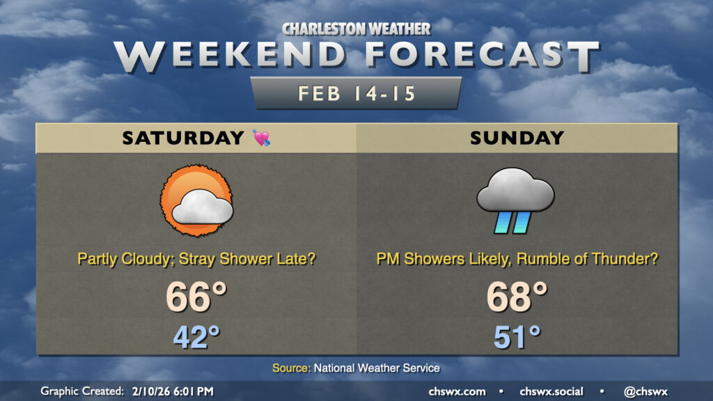
A storm system will develop to our west this weekend, with the return flow ahead of it sending highs back into the mid-60s for Saturday and the upper 60s for Sunday. Saturday should get in mostly rain-free, with the chance for a stray shower in the late evening. We won’t be able to say the same for Sunday, though, with showers likely affecting the area by afternoon into the overnight. Depending on how far north an area of low pressure tracks, a little destabilization could take place for some thunderstorms, but this is fairly unlikely especially given the nighttime frontal passage (though a little elevated instability can’t be ruled out). Sunday will bring more substantial rains to the area, but it still won’t be enough to really put too much of a dent in the drought, nor will it be enough to cause major problems across the area. Stay tuned as the forecast continues to take shape with more high-resolution data over the next few days.
Follow my Charleston Weather updates on Mastodon, Bluesky, Instagram, Facebook, or directly in a feed reader. Do you like what you see here? Please consider supporting my independent, hype-averse weather journalism and become a supporter on Patreon for a broader look at all things #chswx!