Weekend forecast: Quiet Saturday, showers (and maybe a thunderstorm) on Sunday
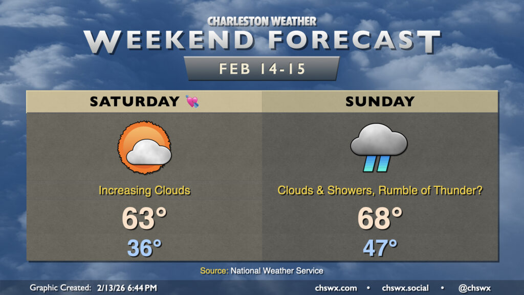
While Valentine’s Day looks lovely, Sunday will decidedly not live up to its name as a storm system affects the area. From there, quite a warming trend develops, especially for the second half of next week.
Saturday will start with a bit of Mother Nature’s cold shoulder, with lows dipping into the mid-30s to start the day. A light wind will make it feel a touch cooler, too, with wind chills falling near freezing. Plenty of sunshine will help lift temperatures into the low-to-mid-60s in the afternoon, though. We’ll see some uptick in cloud cover as the day goes on, but overall, it should be a lovely day for however you celebrate love.
Sunday turns more unsettled as energy aloft drives a surface low and its cold front toward the area during the day. Showers will be possible at any point pretty much all day, with the best risk for more widespread rain arriving in the afternoon and evening hours as the surface low makes its closest approach. A rumble of thunder or two will not be out of the question as a little elevated instability should exist ahead of the front; where thunderstorms form, locally heavier amounts of rain will be possible. Generally speaking, most folks should expect a half-inch to an inch of rain — certainly needed as moderate drought conditions overspread the Lowcountry. We’ll be in the warm sector of this storm, so expect temperatures to head into the upper 60s after starting in the upper 40s despite the expectation for showers and thunderstorms.
Looking ahead: Turning even warmer next week
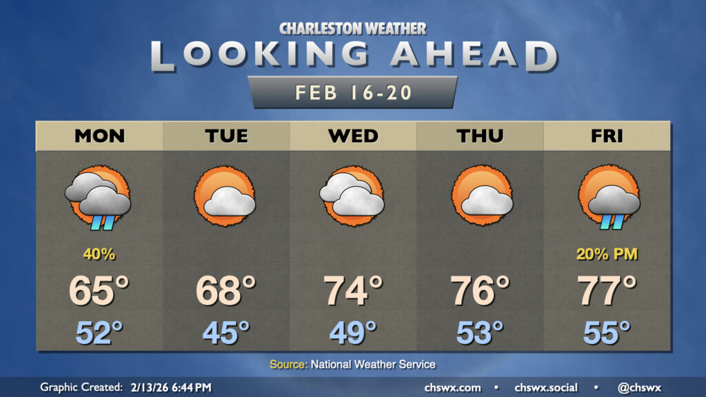
Shower activity could linger through Monday morning, but once it clears, that’ll do it for rain for the next few days. High pressure ridges in aloft across the eastern US, pushing the jet stream well to the north and keeping the colder air bottled up there, too. Temperatures respond nicely; highs in the mid-60s on Monday turn into upper 60s on Tuesday as high pressure traverses the area. The surface high then shifts southeast of the area, turning wind directions more out of the south and southwest. This will drive a pretty solid stretch of spring-like weather for the second half of the work week, with highs in the mid-70s Wednesday and Thursday, perhaps reaching the upper 70s on Friday. We should see another storm system move across the Great Lakes states late week, which could drag a front by and kick up a shower or two on Friday, but there’s a good bit of model disagreement at this range, so assume that there will be some changes as we go into next week.
Follow my Charleston Weather updates on Mastodon, Bluesky, Instagram, Facebook, or directly in a feed reader. Do you like what you see here? Please consider supporting my independent, hype-averse weather journalism and become a supporter on Patreon for a broader look at all things #chswx!