The week ahead: Spring preview returns with gusto
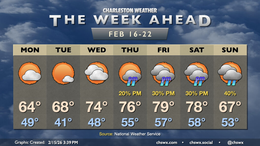
After some much-needed rain on Sunday, sunshine and warmth return for the new work week as high pressure remains the main weather driver for a few days before shower chances return to the picture later in the week.
Clouds will be diminishing Monday in the wake of Sunday’s departing storm system. Temperatures will start on the warm side as mostly cloudy skies overnight help to insulate the atmosphere some, with lows falling to the upper 40s to low 50s. Temperatures will then peak right around mid-February normals, generally in the low-to-mid-60s. Tuesday morning runs cooler with slightly better radiational cooling, but we’ll start to see a warming trend commence overall as highs Tuesday afternoon run in the upper 60s to near 70° under mostly sunny skies.
High pressure will then begin to slip offshore Wednesday, and temperatures will spring into action as a result. Lows on Wednesday will run in the upper 40s, while temperatures will head into the mid-70s in the afternoon despite an uptick in cloud cover. The warming trend continues Thursday and peaks on Friday, when temperatures could challenge the 80° mark.
The forecast gets a little murkier heading into the weekend as guidance is split on how an upper-level trough evolves over the Midwest as well as whether a cool wedge front will try to backdoor into the area on Saturday. Right now, the forecast leans away from that Saturday frontal passage, with forecast highs once again expecting to head into the upper 70s. The warmer guidance suggests that the record high of 83°, set in 2023, needs to be monitored. Guidance generally agrees, though, that Sunday will start a cooling trend in the wake of the front, with forecast highs only getting into the upper 60s. Rain chances will be contingent on the timing of the front and/or a potential storm system. As always, there are plenty of details to work out as we get into that 5-7 day range, so just keep an eye on forecast updates throughout the week.
Follow my Charleston Weather updates on Mastodon, Bluesky, Instagram, Facebook, or directly in a feed reader. Do you like what you see here? Please consider supporting my independent, hype-averse weather journalism and become a supporter on Patreon for a broader look at all things #chswx!