Rest of the work week: 70s return, showers to follow
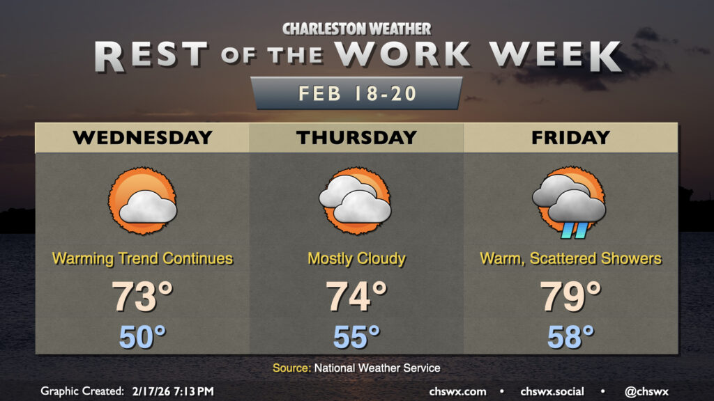
After a fairly warm day (away from the coast, anyway, where temperatures ran some 10°+ cooler), we’ll turn even warmer on Wednesday as high pressure slips offshore, pumping in warmer air from the south and southwest. Wednesday starts around 50° with perhaps a few patches of fog, and we’ll warm well into the low-to-mid-70s under a mix of sun and clouds. Winds will be a bit breezy out of the southwest, generally around 10-15 MPH during the afternoon as mixing from daytime heating taps into 25-30 MPH winds a few thousand feet off the deck.
We’ll start a little warmer on Thursday with more cloud cover to insulate our part of the world; lows should dip only to about the mid-50s, some 10-15° above normal for this point in the year. More cloud cover will limit heating a bit, but temperatures will still head into the mid-70s in the afternoon. A stray shower isn’t totally out of bounds, but most of us should stay dry. Once again, breezy conditions are expected during the day as daytime heating helps tap into stronger winds aloft.
Even warmer temperatures are expected Friday as a cold front begins to draw closer to the area. We could also see some showers develop during the day, though it won’t rain all day at any one location. Rain should be generally light. Lows bottom out only in the upper 50s, but this will still be a few degrees off the record warm low temperature of 64° set in 1939. Despite a fair bit of cloud cover, temperatures could push 80° in the afternoon. The record high of 82° set in 2018 seems safe, but we’ll see if some peeks of sunshine can make it interesting.
Weekend outlook: Cold front brings temperatures back to earth
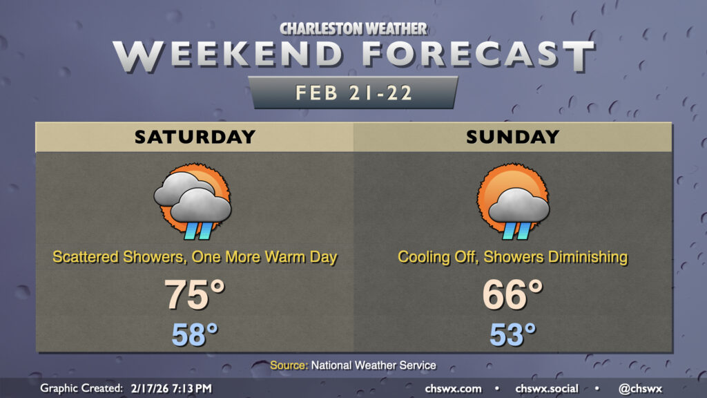
We’ve got one more warm day on Saturday ahead of a cold front that will move by early in the day Sunday. It’ll come along with some shower chances, with those chances maximizing Saturday afternoon through Sunday morning. There’s still some model disagreement on the exact timing of the front, but regardless, expect showers to shut off Sunday morning with cooler air moving in; highs will top out in the mid-60s, almost 10° cooler than Saturday. The new work week will get off to a colder start, with the potential for subfreezing temperatures returning Tuesday morning.
Follow my Charleston Weather updates on Mastodon, Bluesky, Instagram, Facebook, or directly in a feed reader. Do you like what you see here? Please consider supporting my independent, hype-averse weather journalism and become a supporter on Patreon for a broader look at all things #chswx!