Friday & the weekend: Unsettled and warm through Saturday, then cooling begins Sunday
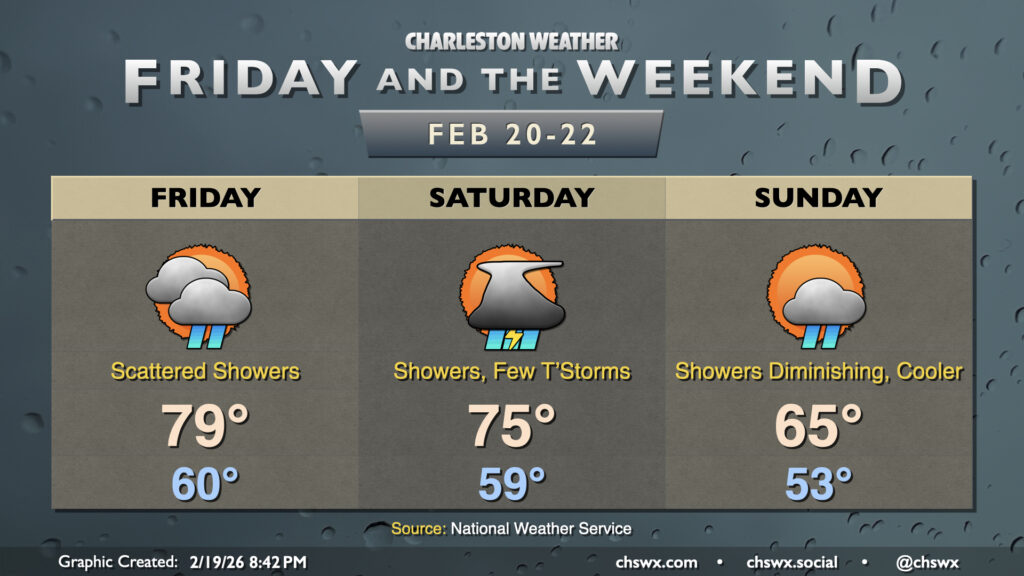
The warm spell peaks on Friday before a cold front affects the area over the weekend. The first 80° day of 2026 is not out of the question on Friday, though a scattering of showers will potentially put a damper on that possibility, especially heading into the afternoon. Like the past couple days, another breezy day looks to be on tap as well, with winds gusting 25-30 MPH at times as the heating of the day helps tap into somewhat stronger winds aloft. As for showers, they aren’t out of the question really at any point in the day, though coverage should increase a bit getting later into the afternoon as the cold front stalls out across the Upstate and Midlands. Not expecting too much in the way of rainfall amounts on Friday, though some brief downpours aren’t out of the question, especially inland from the coast where a little more instability may exist.
Saturday should be more unsettled as low pressure develops along the front, which by morning should be draped near the Tri-County area, and moves into the Carolinas. The position of the front will govern the thunderstorm threat for Saturday, but as far as showers go, expect the potential for showers pretty much all day. Gusty winds will be possible at times, especially if and where thunderstorms can get going and tap into stronger winds aloft. The best thunderstorm threat will be found generally inland of the immediate coast, where the cooler marine air will tamp down on instability. Where thunderstorms form, there is the potential for not only some heavy rain but also perhaps a damaging wind gust or two. The greatest risk for severe weather appears to be along and south of the Savannah River (heading into Georgia), but we’ll keep an eye on how things evolve. The uncertainty around the front’s location will govern highs, but if it nudges more north of the area later in the day as is currently expected, temperatures should peak in the mid-70s; showers and storms will keep temperatures from getting too out of hand.
The aforementioned low pressure will drag the cold front across the area for good on Sunday. Expect showers and clouds to diminish throughout the day, ending on a clearer and cooler note as highs should only peak in the mid-60s. We may return to freezing Monday morning, and almost certainly will Tuesday morning, as Old Man Winter tries to run cover for Phil on his fairly lousy Southeast prognostication.
Follow my Charleston Weather updates on Mastodon, Bluesky, Instagram, Facebook, or directly in a feed reader. Do you like what you see here? Please consider supporting my independent, hype-averse weather journalism and become a supporter on Patreon for a broader look at all things #chswx!