Rest of the work week: Record warmth expected Wednesday, then a front cools us off
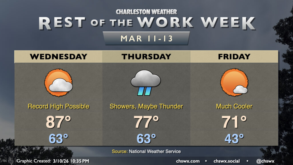
Another very warm day is on tap for Wednesday on the heels of the warmest day thus far in 2026. Wednesday’s forecast high of 87°, if it verifies, would break the daily record high for March 11 of 85° set in 2015. We’ll have plenty of sunshine for a good bit of the day, though cloud cover will tick up in the evening ahead of a cold front that will begin to restore a little order to a spring preview that’s gotten a bit out of hand.
The front will arrive Thursday with some more much-needed rain for the Lowcountry. Expect temperatures to start in the low-to-mid-60s once more, with highs limited to the upper 70s with clouds and rain expected to feature prominently, particularly in the afternoon and evening hours. A few thunderstorms will also be possible, but right now it doesn’t look like severe weather will be an issue.
Behind the front, temperatures will cool sharply, though “sharply” in this case means “closer to normal for mid-March.” Temperatures Friday start in the low to mid-40s, warming to the low 70s in the afternoon under mostly sunny skies.
Saturday remains rain-free, though the weather starts to turn more unsettled Sunday into Monday before an even sharper cooldown arrives for Tuesday.
Follow my Charleston Weather updates on Mastodon, Bluesky, Instagram, Facebook, or directly in a feed reader. Do you like what you see here? Please consider supporting my independent, hype-averse weather journalism and become a supporter on Patreon for a broader look at all things #chswx!