The week ahead: Potentially rambunctious Monday leads to a sharp, but short-lived, cooldown
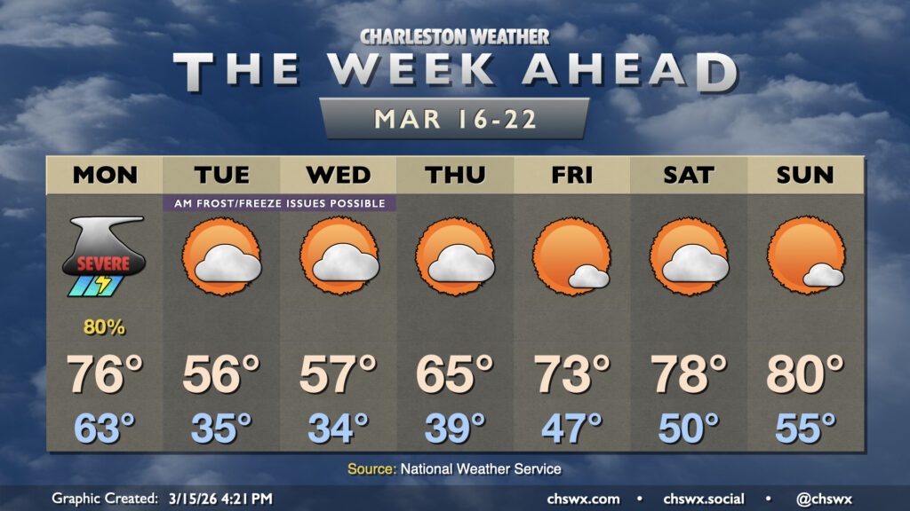
The week ahead gets off to a bit of a rough start as a potent cold front moves through the area Monday, bringing the first significant severe weather threat of 2026 to the Lowcountry. From there, temperatures fall off drastically, with some frost and freeze issues possible especially inland. We’ll warm back up heading into the weekend, though.
Monday’s severe threat
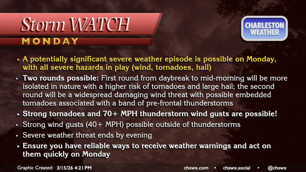
As mentioned, Monday could turn very busy in the weather department as a cold front accompanied by a very strong trough of low pressure aloft moves into the Southeast and Mid-Atlantic states, setting up an environment that will be conducive to potentially significant severe weather throughout the day Monday, starting roughly from daybreak through early evening.
Two rounds of storms are possible. The first round would be more isolated, discrete cells; if these can develop and become severe, they could not only produce damaging straight-line winds but may be capable of producing large hail (up to 2″) and strong tornadoes. From there, the more widespread threat for severe weather arrives in the Lowcountry from roughly 1PM on as a line of thunderstorms associated with the cold front pushes eastward. This line will contain the greatest risk for damaging straight-line wind gusts, which could push 70-75 MPH in the strongest storms. Embedded tornadoes are also quite possible within the leading edge of the line as well, and these could be strong as well. The front should sweep the line of storms offshore by 4-5 PM, ending the severe weather threat.
These storms will be moving quickly, so warnings may not come out with much lead time. Know where your safe place is at home, work, or school in case a severe thunderstorm threatens your location, and act quickly if a warning is issued. Remember: A watch means the conditions are favorable for severe storms to form. A warning means that a severe storm is occurring and is likely to affect the warned area, requiring quick action. We don’t really do basements here, so for tornadoes, getting to an interior room on the lowest floor of a sturdy structure is the best move for your safety.
Outside of thunderstorms, winds will still be quite gusty, with gusts to 40 MPH at times especially on bridges and overpasses. Temperatures will be quite mild as well, with low-to-mid-60s lows warming into the mid-70s in the afternoon.
Frost and freeze concerns
Once the front gets offshore, cooler and drier air will punch into the area, making Tuesday feel significantly cooler than we’ve felt in a while. Temperatures fall to the mid-30s by Tuesday morning, but elevated winds should keep frost formation to a minimum. Winds will calm down Tuesday night, though, increasing the potential for frost across the area. With the growing season now underway, the National Weather Service will issue Freeze Watches/Warnings and Frost Advisories. No such products are in effect right now for our part of the Lowcountry, but that may change especially as we get through Tuesday.
Warmth returns for the weekend
Cool high pressure remains in force through about Thursday before starting to slip offshore, allowing temperatures to moderate back to the 70s on Friday and perhaps approaching 80° by Sunday. The weather looks fairly quiet heading into the weekend, with just some clouds from time to time.
Follow my Charleston Weather updates on Mastodon, Bluesky, Instagram, Facebook, or directly in a feed reader. Do you like what you see here? Please consider supporting my independent, hype-averse weather journalism and become a supporter on Patreon for a broader look at all things #chswx!