The week ahead: Cooler and a bit cloudier
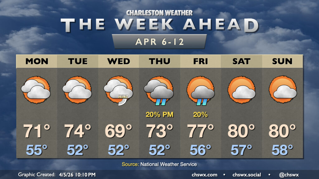
A cold front coming through overnight Sunday into early Monday morning will send temperatures to a more seasonable place for early April through mid-week, though it’ll be a bit cloudier, too. Shower chances return for the second half of the work week before more sunshine and 80s return for the weekend.
Weak high pressure will wedge into the area for Monday, turning winds more northeasterly and keeping some cloudiness in place, though some sun should peek through as well. Temperatures will start in the mid-50s, warming to the low 70s in the afternoon. Winds in the morning could be a bit on the breezy side, but will subside as the day goes on.
We warm up a little Tuesday — think mid-70s — ahead of a front that will usher in a stronger wedge of cool high pressure for Wednesday. Wednesday will be the breeziest day of the week, and with dry air and not a lot of rain across the area, fire weather concerns could once again be elevated. Temperatures Wednesday may not crack 70° owing to the cool northeasterly flow that’ll blanket the area and a mix of sun and clouds.
The next (slight) rain chances for the area arrive Thursday afternoon through Friday as the wedge of high pressure weakens and a trough of low pressure drifts inland. The weakening wedge will allow temperatures to start to rebound, with low-to-mid-70s expected Thursday and mid-to-upper 70s expected Friday. The trough clears the area by Saturday, and with mid-level ridging nudging in from the west, we can expect temperatures to head back to the low 80s for the weekend with more in the way of sunshine.
Follow my Charleston Weather updates on Mastodon, Bluesky, Instagram, Facebook, or directly in a feed reader. Do you like what you see here? Please consider supporting my independent, hype-averse weather journalism and become a supporter on Patreon for a broader look at all things #chswx!