Friday & the weekend: Record highs possible, but changes coming
We’ll see the potential for record heat Friday and Saturday before a front affects the area Sunday, ushering in a few cooler days next week.
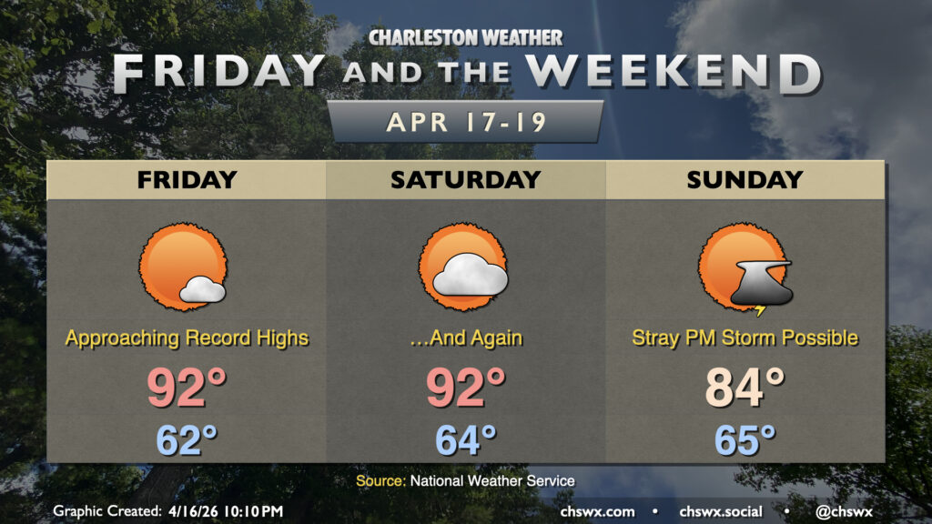
Friday starts in the low 60s, a few degrees above normal for mid-April. Winds going westerly throughout the atmosphere will help to send temperatures well into the low 90s in the afternoon. The current NWS forecast of 92° would break the airport’s daily high temperature record of 91° set in 1967. The westerly flow will also allow warmer temperatures to head closer to the coast, and temperatures could even approach 90° as far east as downtown, where the record of 86° set in 2006 is in jeopardy. Clouds will be few and far between with deep-layer high pressure remaining in place.
High pressure remains in control for Saturday, and even asserts itself a bit more for one more day. As a result, we can expect high temperatures to once again approach record levels Saturday afternoon primarily at the airport; a bit more southerly component to the wind will keep temperatures a bit cooler downtown. Expect highs in the low 90s inland with mid-80s downtown, and even cooler at the beaches. There may be a bit of an uptick in cloud cover especially as a front begins to approach the area later in the day.
The aforementioned front gets through Sunday. Temperatures will head into the low-to-mid-80s before being undercut by the front later in the day. We could even see a stray shower or storm break out in the afternoon and evening hours, but moisture is very limited and there won’t be much rain if in fact it rains at all — certainly unwelcome news given the expansion of severe and even extreme drought into the Lowcountry.
The persistent dry weather has prompted a statewide burn ban that goes into effect at 7am due to extremely dry fuels throughout the state that, even with somewhat unfavorable winds, could still drive an elevated wildfire potential. Beyond Sunday, rain does not appear to be in the cards through at least midweek next week.
Follow my Charleston Weather updates on Mastodon, Bluesky, Instagram, Facebook, or directly in a feed reader. Do you like what you see here? Please consider supporting my independent, hype-averse weather journalism and become a supporter on Patreon for a broader look at all things #chswx!