Friday & the weekend: Wet and cool start to May
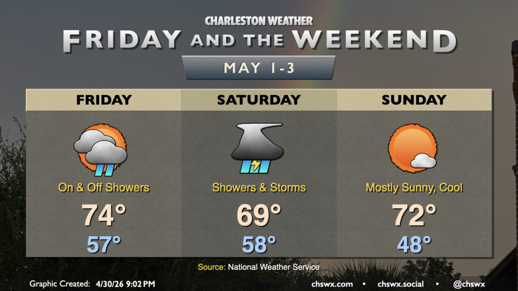
After completing what should go down as the second-driest April on record (only by virtue of measurable rainfall over the past two days), we will get May off to a more unsettled start with some much-needed rain followed by a cool but sunny Sunday. We will also need to keep an eye on tides for possible coastal flooding concerns into the weekend.
The cold front that moved through earlier today will stall out to our south on Friday. Warm and moist air lifting atop that front will gradually build throughout the day, bringing some showers during the day followed by a greater risk for showers and even a few thunderstorms overnight Friday into Saturday. We will need to watch the evening high tide (around 8:54 PM) for the risk for minor coastal flooding courtesy of northeasterly winds and the full moon. Temperatures Friday will run a few degrees cooler than they did on Thursday, with lows in the upper 50s warming to the mid-70s in the afternoon.
Saturday won’t be a great day to get outside to see the Blue Angels, unfortunately. Showers and a few thunderstorms will be possible throughout the day as low pressure develops along the stalled front and traverses the area near the coast. We do need the rain, and it looks like we’ll get a pretty decent round of it — expect many of us to see over an inch of rain through Saturday evening, with some spots perhaps pushing 2″. Rain will shut off by early evening as low pressure shifts away from the area, thankfully ahead of a high tide that may cause some coastal flooding late Saturday evening. Temperatures will range from the upper 50s in the morning to a rain-cooled upper 60s in the afternoon.
Sunday will be the pick day of the weekend, with cool air and low humidity along with plenty of sunshine. We’ll start the day in the upper 40s, warming to just the low 70s in the afternoon despite the sun. It’ll be a really nice day to get out and about, with a stretch of nice days to follow before the next rain chance arrives around Thursday.
Follow my Charleston Weather updates on Mastodon, Bluesky, Instagram, Facebook, or directly in a feed reader. Do you like what you see here? Please consider supporting my independent, hype-averse weather journalism and become a supporter on Patreon for a broader look at all things #chswx!