The week ahead: Not quite as hot at times, staying periodically unsettled
Fairly standard summertime weather continues for the week ahead, though we shouldn’t run quite as hot as we did this past weekend, with no record highs in jeopardy of being toppled this go-around.
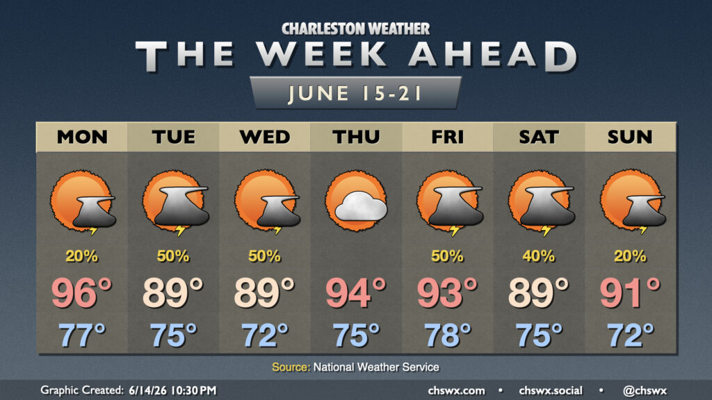
After a fairly active Sunday afternoon and evening of thunderstorms bringing much-needed rain to the area (albeit with the risk for severe weather), we should run quieter on Monday as high pressure briefly nudges back in aloft. Temperatures Monday will run much warmer than normal for one more day, with highs in the mid-90s expected after an upper-70s start. Heat indices will still run generally in the 104-106° range in the afternoon; while this falls short of the advisory criteria of 108° for two consecutive hours, it will still be plenty warm and worthy of frequent breaks in the shade. Shower and thunderstorm coverage looks much more limited on Monday, but a few popup storms on the seabreeze and outflow boundaries from other collapsing storms remain possible.
A cold front will approach the area late Monday and stall out to our northwest Tuesday and Wednesday. This will bring shower and thunderstorm chances up a few ticks, and help to bring temperatures down a bit as well. Highs should peak in the upper 80s to around 90° in the afternoons, a far cry from where we’ve been the past few days. Rain coverage may be enhanced a bit by some tropical moisture making its way out of the Gulf and across the southeastern states, but right now it looks like the greatest risk for heavy rain will remain in western North Carolina, which will have the closet proximity to the disturbance.
The front washes out by Thursday, bringing shower and storm chances down a bit. Temperatures recover to the mid-90s for Thursday with lower afternoon thunderstorm chances due to some brief capping aloft before more unstable air returns for Friday, kicking shower and thunderstorm chances back up with another surface front approaching.
The weekend could still feature some precipitation as a front tries to nudge through — given the time of year, I have doubts — but the going forecast right now is that we should run generally around normal as far as temperatures go, with highs in the upper 80s to low 90s.
Follow my Charleston Weather updates on Mastodon, Bluesky, Instagram, Facebook, or directly in a feed reader. Do you like what you see here? Please consider supporting my independent, hype-averse weather journalism and become a supporter on Patreon for a broader look at all things #chswx!