The week ahead: Summertime heat, humidity, and storms
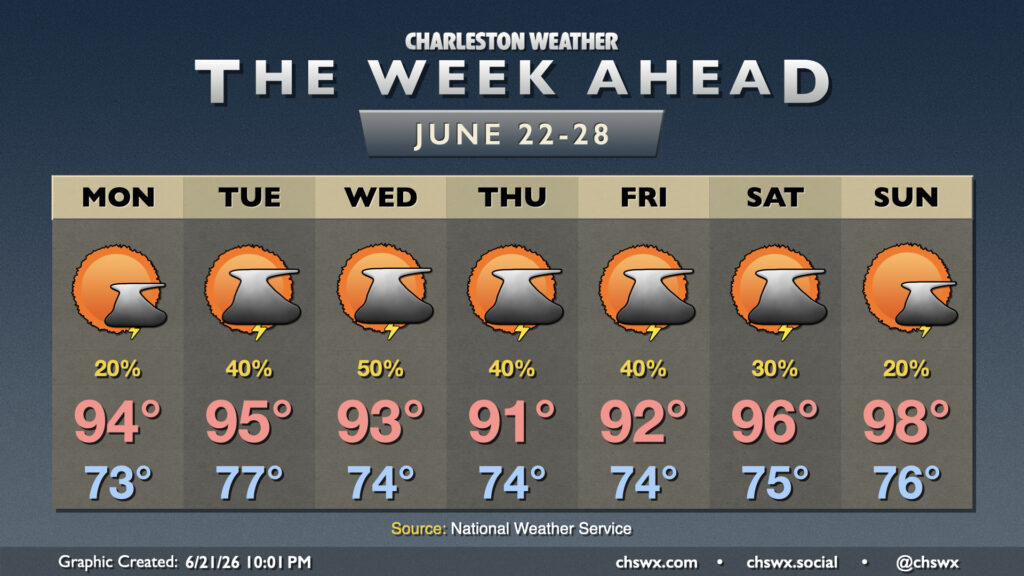
Weather worthy of the summer solstice will continue this week with highs in the 90s and a shot at afternoon thunderstorms each day.
We’ll start Monday morning in the low-to-mid-70s, warming to the mid-90s in the afternoon with heat indices pushing 102° courtesy of low-70s dewpoints. The upper-level flow is fairly zonal (west to east), while surface high pressure in the Gulf will extend northward across the area. This will keep coverage of showers and thunderstorms generally isolated to scattered during peak heating; basically, most stay dry, but a few could still see a storm.
From there, a broad trough sets up over the eastern half of the country, which helps drive a front tantalizingly close for Tuesday and Wednesday. That front should stall out and fall apart west of us, but it will help improve the risk for afternoon showers and storms through midweek. Highs Tuesday head into the mid-90s after an upper-70s start ahead of the front, moderating to the low 90s each day thereafter with occasional disturbances interacting with the seabreeze to keep a scattering of showers and thunderstorms in the forecast each day through Friday.
Ridging begins to build back in aloft over the weekend, turning up the heat and turning down the rain chances as the atmosphere will be capped. Highs head to the mid-90s on Saturday and the upper 90s on Sunday, with the potential for advisory-level heat indices especially Sunday.
Follow my Charleston Weather updates on Mastodon, Bluesky, Instagram, Facebook, or directly in a feed reader. Do you like what you see here? Please consider supporting my independent, hype-averse weather journalism and become a supporter on Patreon for a broader look at all things #chswx!