The week ahead: Unsettled start with fewer heat advisories
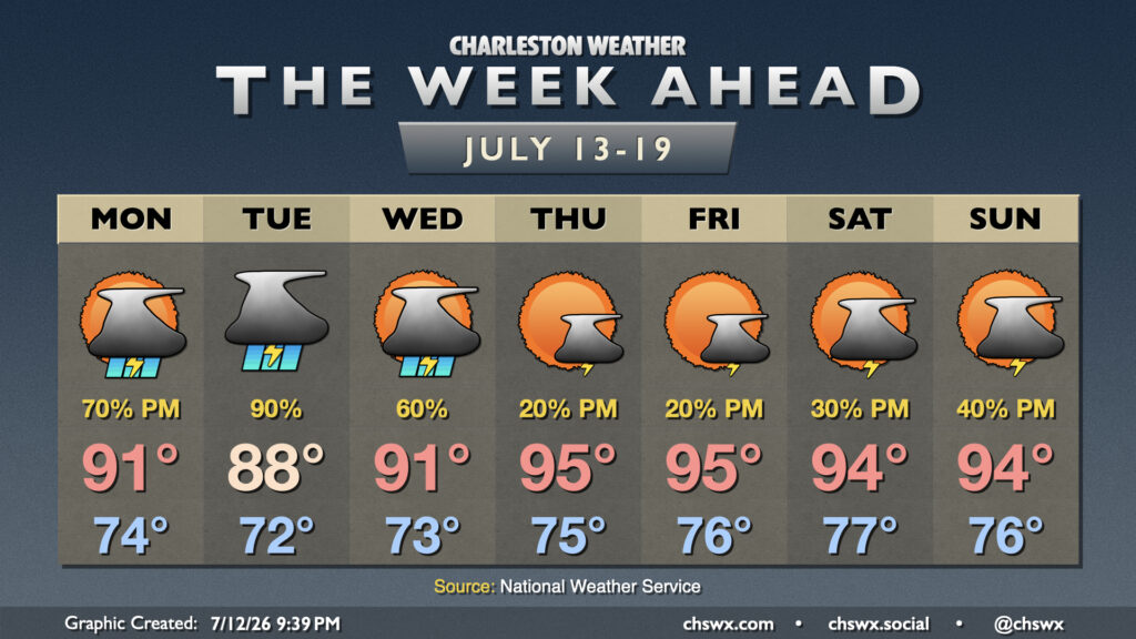
After a week of consecutive heat headlines, whether they be Heat Advisories or Extreme Heat Warnings, a front dropping in from the north — and the accompanying unsettled weather — will take the edge off the heat for at least a few days.
The next few mornings will start a bit cooler than we’ve felt lately in the wake of the aforementioned front. Still, we’ll experience warmth and mugginess that typical Julys in the Lowcountry bring, with lows in the low to mid-70s inland and pushing the upper 70s toward the coast and into downtown. Highs Monday through Wednesday will peak in the upper 80s to low 90s, with the coolest day likely Tuesday (also corresponding with the greatest coverage of storms). By Thursday, though, high pressure aloft reasserts itself, and temperatures respond with lows in the mid-to-upper 70s and highs solidly in the mid-90s. Heat indices will head back into the 100s as well, though it remains to be seen if we’ll get back to Heat Advisory criteria or not.
Shower and thunderstorm chances will be greatest Monday through Wednesday as the front stalls nearby and degenerates into a trough. Monday’s storms should start in the afternoon as we have seen over the past few days, while the lingering boundary will keep storm chances in place for much of the day Tuesday before we trend back to afternoon storms Wednesday. Storm chances will dip Thursday and Friday afternoons before starting to creep back up a bit heading into the weekend. While we shouldn’t see a repeat of last Friday and Saturday’s severe weather, there is a risk for an isolated storm or two to become severe where boundaries collide and updrafts become vigorous.
Finally, we will need to keep an eye on evening high tides through Wednesday for the potential for salt water flooding as we reach a new moon at perigee, which ultimately acts as an astronomical one-two punch for high water levels in the harbor. Given this risk, any storms that fire up in the coastal corridor into Downtown will need to be watched closely for the potential for more widespread flooding concerns. Stay tuned for Coastal Flood Advisories from the National Weather Service.
Follow my Charleston Weather updates on Mastodon, Bluesky, Instagram, Facebook, or directly in a feed reader. Do you like what you see here? Please consider supporting my independent, hype-averse weather journalism and become a supporter on Patreon for a broader look at all things #chswx!