The week ahead: Unsettled, but not quite as hot
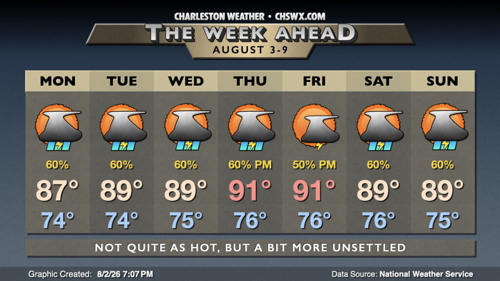
The first week of August looks unsettled with more rain on the way, especially in the first half of the week as low pressure aloft becomes cut off and stalls for a couple days.
At the surface, a cold front will stall out just around the Upstate, where it will fluctuate for the next few days. A solid feed of moisture into the area will continue, and this combined with a trough to our west will help to keep showers and thunderstorms in the picture. Monday will start in the mid-70s, warming to the mid-to-upper 80s in the afternoon owing to cloud cover and thunderstorms in the area. Thunderstorms will be likely, though it won’t rain all day in any one location. The greatest risk for heavy rainfall is going to exist closer to the coast starting around mid-morning before progressing inland. We’ll want to monitor for the risk for flooding if storms train on each other.
From there, the mid-level trough to the west seems to cut off into a closed low and meanders around Georgia and Tennessee for the following couple days. This keeps temperatures down a touch and rain chances elevated for Tuesday and Wednesday; we can once again expect highs to peak in the upper 80s to around 90° after starting in the mid-70s each day. The front begins to fall apart Thursday as Atlantic high pressure nudges in from the east, bringing about a more normal summertime pattern for a couple days with temperatures heading back into the 90s and thunderstorms turning a little more scattered, especially on Friday. A coastal trough will sharpen along the coast over the weekend, elevating afternoon thunderstorm chances once more.
Follow my Charleston Weather updates on Mastodon, Bluesky, Instagram, Facebook, or directly in a feed reader. Do you like what you see here? Please consider supporting my independent, hype-averse weather journalism and become a supporter on Patreon for a broader look at all things #chswx!