Jared Smith founded @chswx on Twitter in 2008 as an experiment in disseminating weather data through social media. In the ensuing decade-and-a-half, @chswx has provided live coverage of tropical cyclones, tornadoes, severe weather, and even a couple bouts of winter weather to the good people of Charleston, SC.
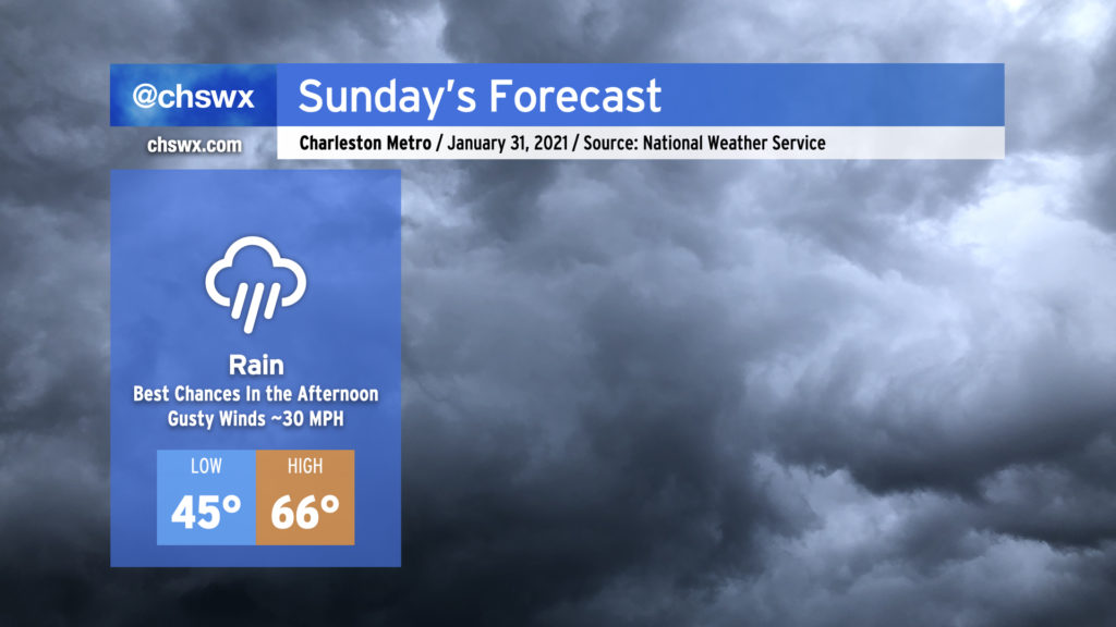
Cloud cover has arrived, and the rain will pick up as Sunday goes on as yet another cold front makes its way toward our neck of the woods. The best chances of the heaviest rain will come later in the afternoon into the evening hours, but showers will be possible at really any point of the day. Once it’s all said and done, we could log another half-inch to inch of rain in the books to close out January.
Temperatures will run in the mid-60s with a stiff southerly wind pumping warm, moist air into the region. Gusts could reach 30 MPH at times, particularly on exposed overpasses and bridges, so be cautious when traveling tomorrow.
There will be a small risk of some minor coastal flooding with tomorrow morning’s high tide, which would primarily affect areas near The Citadel and around Lockwood Dr. High tide is forecast to peak a little after 9:30am.
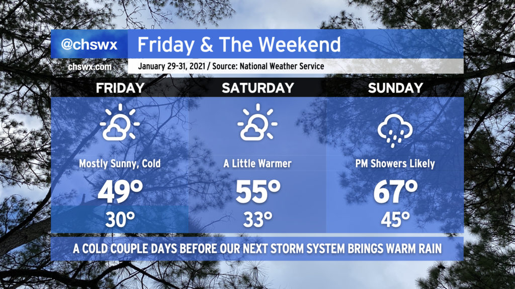
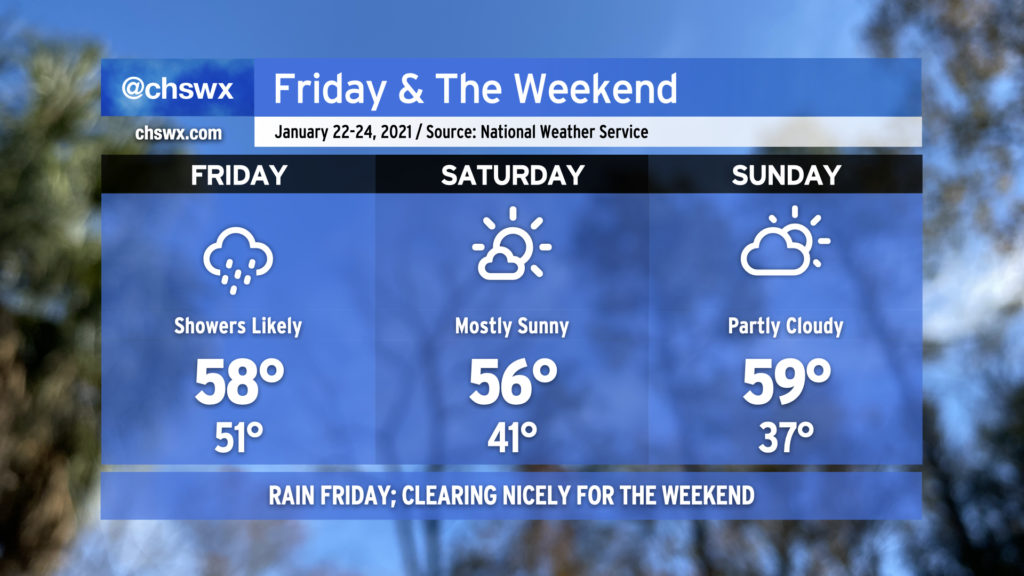
Chilly high pressure will continue to build into the area tonight into Friday, bringing freezing temperatures very close to the coast to start the last day of the work week. Temperatures will struggle to reach 50° despite full sunshine. Expect mostly sunny skies to prevail through Saturday as temperatures moderate back into the mid-50s in the afternoon. Our next storm system begins to affect the area possibly as early as late Saturday night, with rain likely on Sunday. Can’t rule out a few rumbles of thunder, either. It’ll be noticeably warmer — highs in the mid-60s will be common Sunday in the warm sector of the storm system before it moves through late Sunday into early Monday.
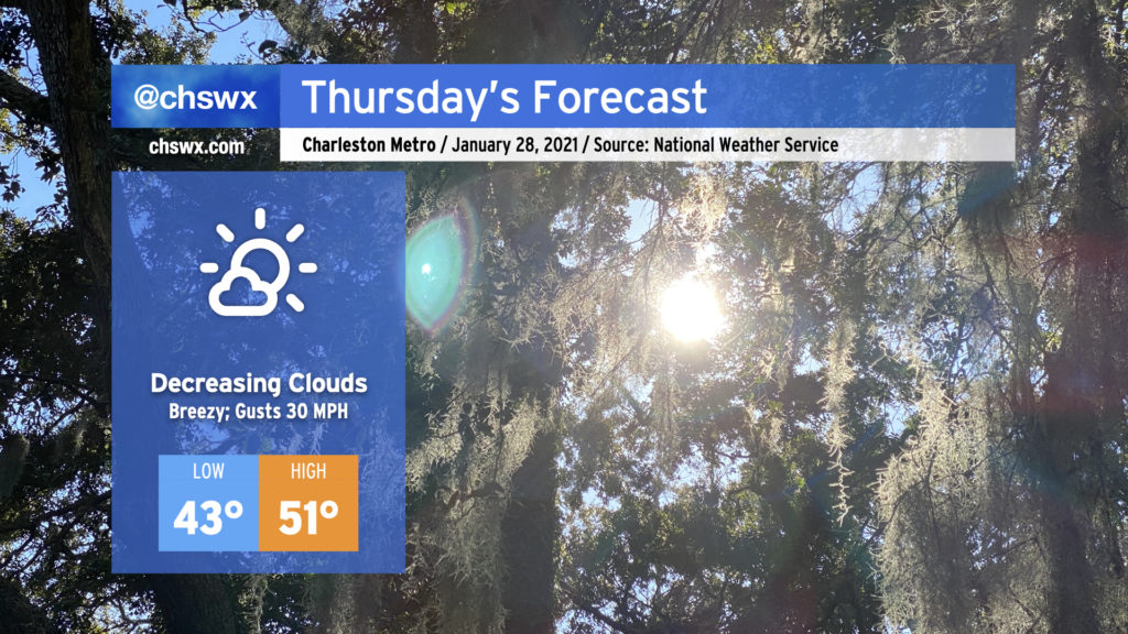
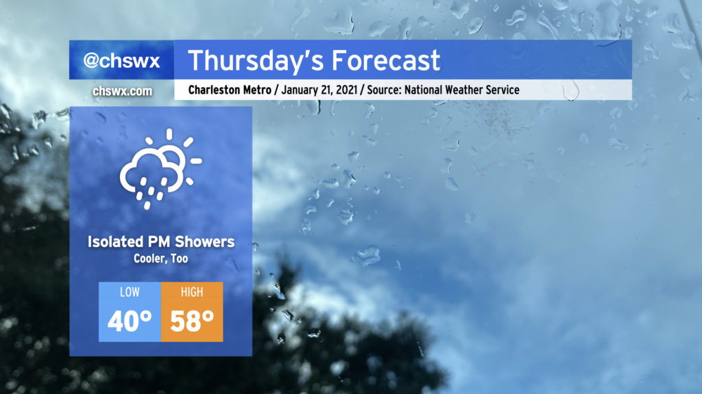
A cold front will swing through overnight, bringing much cooler and drier air to the Lowcountry for the next few days. Wind gusts 30-35 MPH could be common overnight into Thursday morning, with higher gusts possible on bridges and overpasses. Be careful during your morning commute.
Skies should clear out by midday, but despite plenty of sunshine, temperatures will struggle to the low 50s as cold air pumps into the area. But, hey, the sun will come out, and that’s better than we can say for the last few days.
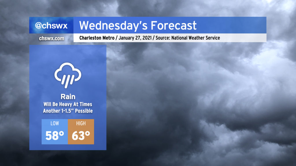
Get ready for a soggy Wednesday as a cold front and upper disturbances combine to produce quite a bit of rainfall. Atmospheric moisture will be abnormally abundant for this time of year, allowing for most areas to receive over an inch of rain tomorrow. Temperatures will top out in the low 60s as a front sags south of the area.
Rain looks to begin to taper off in the evening hours as a secondary front pushes offshore. This will bring in cooler and drier air overnight, and by sunrise Thursday we should be seeing rapid clearing.
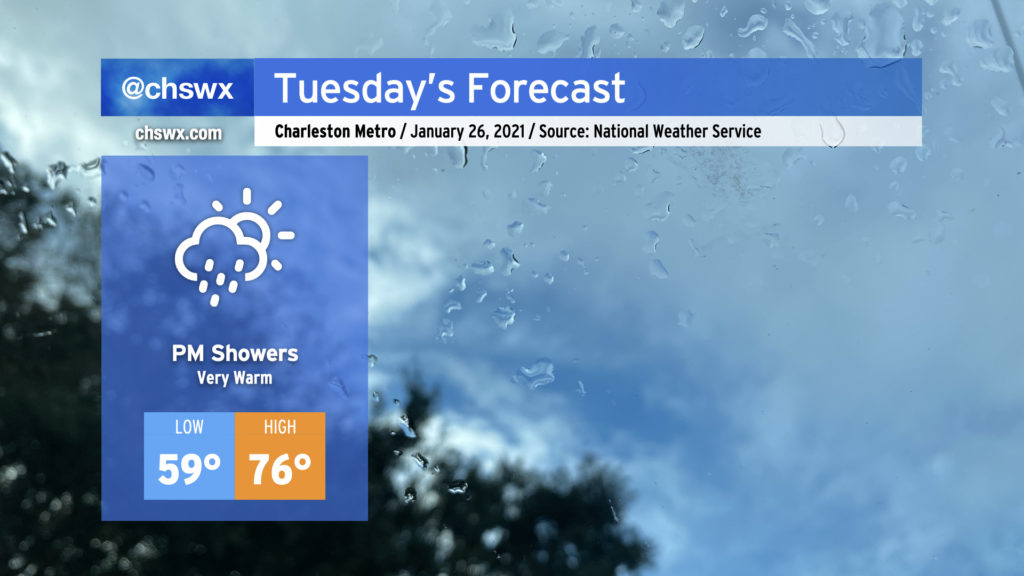
After the warmest day since New Year’s today, we’ll get back into the mid-70s for Tuesday as we remain in the warm sector of a storm system cutting across Tennessee this evening. We’ll be under mostly cloudy skies with a few peeks of sun throughout the day, with shower chances increasing as the evening progresses ahead of what appears to be a very soggy Wednesday across the Tri-County.
The forecast high of 76° at the airport runs well above the normal high of 60° for January 26. The record high is 80°, set in 1949.
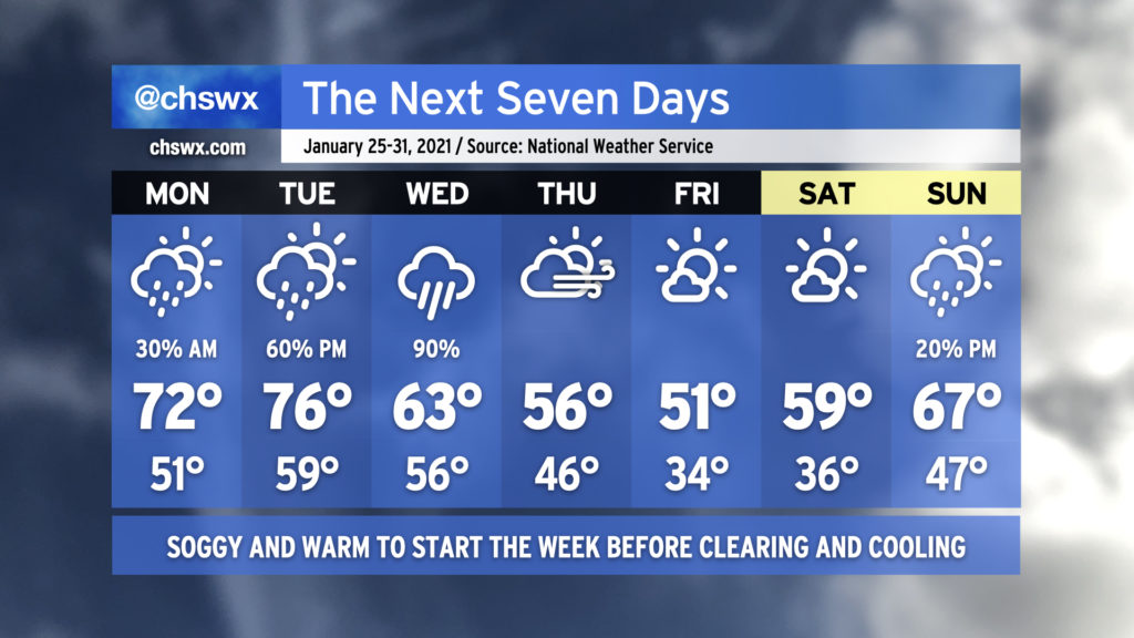
The final week of January 2021 (already!) will start off fairly warm before returning to below-normal temperatures to head into the weekend. Forecasted highs in the 70s on Monday and Tuesday would be the first 70+ temperatures since January 1-2. This abnormal warmth will be swept away with a soggy storm system come Tuesday evening into Wednesday, though, bringing in cooler and drier conditions to close out the week. Then, the progressive pattern ushers in another storm system to possibly bring some rain and warmer temperatures back to the area as early as Sunday.
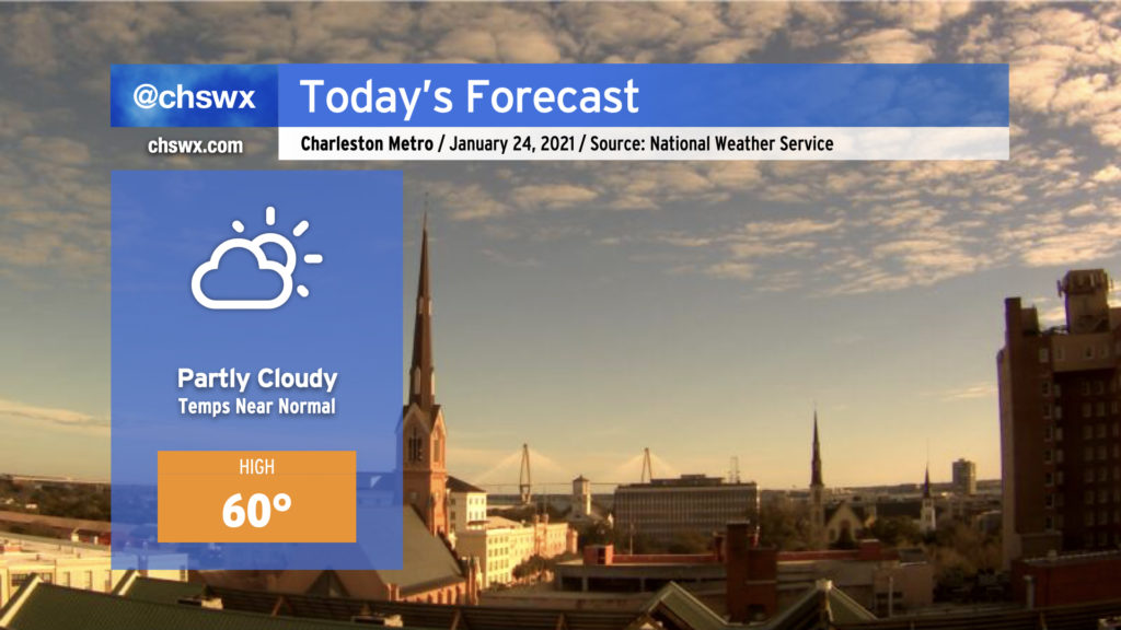
After a Saturday full of brilliant sunshine and somewhat overachieving high temperatures, we’ll be back to the low 60s today with a few more clouds. You might notice it getting a little more humid as the day goes on, with winds switching to a more easterly/southeasterly direction this afternoon.
High-res guidance still wants to spit out a couple showers in the area very late tonight, but if there will be any rain, it would probably sprinkle in more toward Monday — and even then, there’s just a slight chance in the forecast right now. Will have more on this and the week ahead later tonight, but for now, enjoy your Sunday!
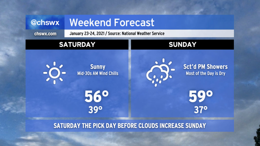
Well folks, we made it — another weekend is here. Temperatures will remain at or a little below normal, particularly on Saturday, as cooler and drier air pushes into the area from the north thanks to high pressure pushing down the Eastern Seaboard into the Carolinas. We’ll start Saturday in the 30s, with wind chills feeling a few degrees cooler, and only head to about 55-56° or so in the afternoon despite full sunshine. (Northeast winds will do that to you.)
Clouds increase during the day on Sunday as high pressure departs and moisture filters back into the area. We could see some showers late in the day into Monday as a warm front lifts north, but right now I expect much of Sunday to remain dry. Temperatures will run a little warmer, around 60° in the afternoon.
Overall, I’d say Saturday is definitely the better of the two days if you have outdoor plans despite the slightly cooler temperatures! Have a good weekend, everyone.
We’re in for another gray, rainy day on Friday as low pressure develops and slides south of the area along a stalled front. The best chance of rain will be during the morning hours before tapering off in the afternoon. Temperatures will top out in the upper 50s.
It gets better, though. Expect skies to clear by Saturday morning with a northeast breeze helping keep temperatures in the mid-50s despite all the sunshine. We’ll start Sunday in the mid-30s before temperatures head up to near 60° under increasing cloud cover. If I had to pick, I’d probably choose Saturday for more abundant sunshine, but Sunday won’t be any slouch either with a little warmer temperatures in the afternoon.
After an afternoon in the mid-to-upper 60s across the Lowcountry, clouds and eventually some showers return to the area tomorrow as a cold front begins to approach from the northwest. The rain chance will begin in the afternoon and increase overnight into Friday as the front sags southward through the region. Keep rain gear handy if you are out and about tomorrow.