Jared Smith founded @chswx on Twitter in 2008 as an experiment in disseminating weather data through social media. In the ensuing decade-and-a-half, @chswx has provided live coverage of tropical cyclones, tornadoes, severe weather, and even a couple bouts of winter weather to the good people of Charleston, SC.
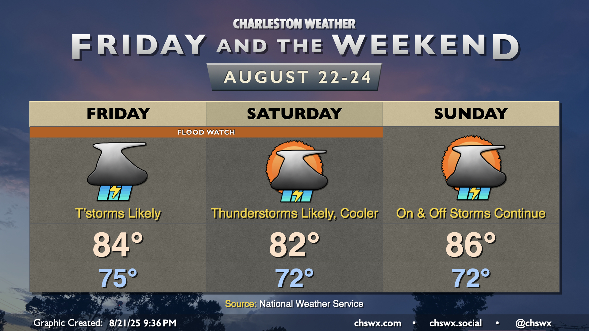
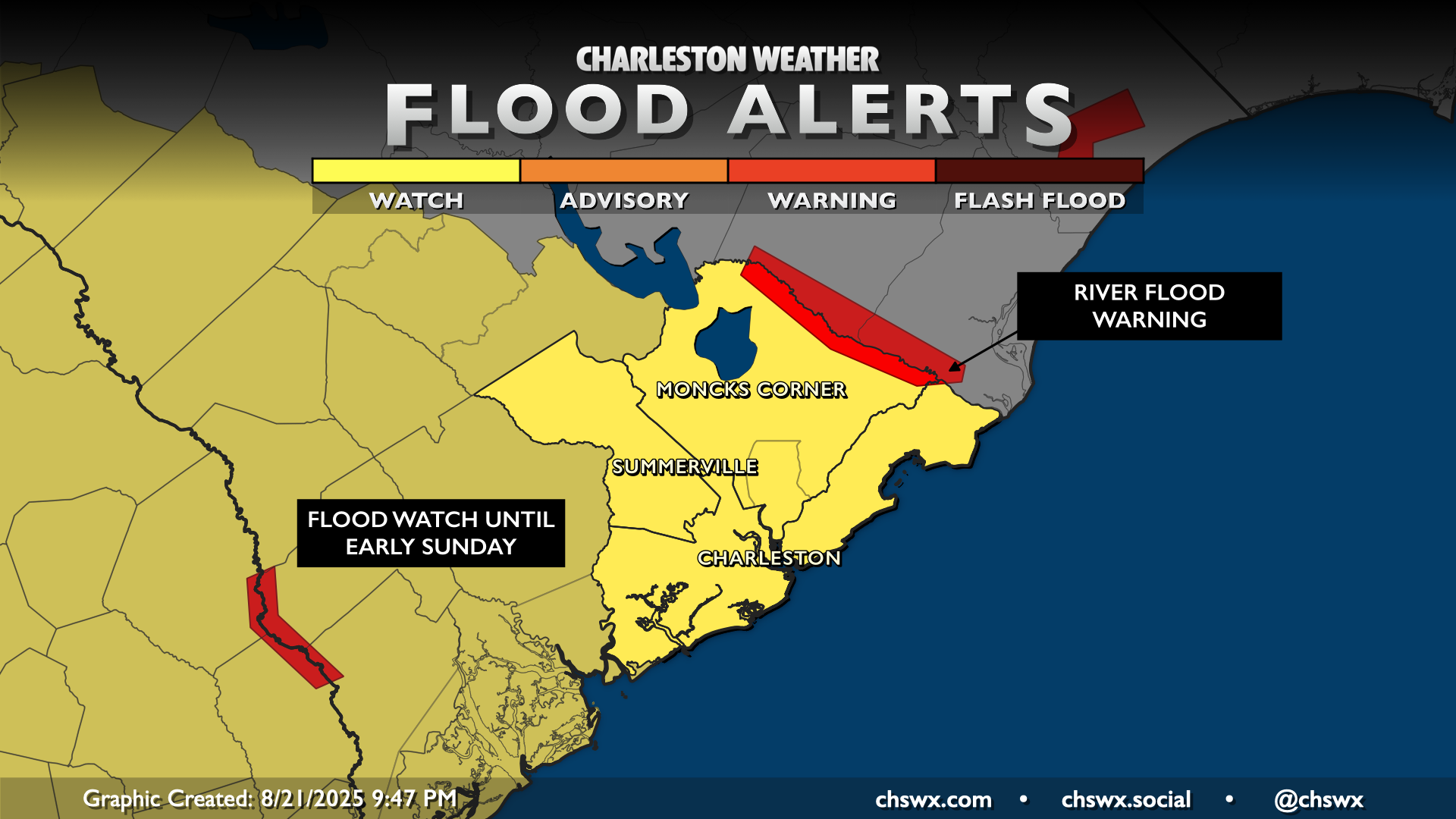
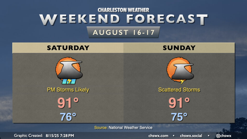
Friday and the weekend will be on the unsettled side as a front stalls out nearby. Waves of low pressure developing along the front will help to tap into resurgent tropical moisture, and given how soggy it’s been this month, it won’t take terribly much for flooding to develop. Thus, a Flood Watch will go into effect at 8am Friday, lasting into late Saturday night/early Sunday morning. We’ll want to pay close attention around the evening high tides on Friday and Saturday, as water levels in Charleston Harbor will remain elevated in the wake of Hurricane Erin. Salt water flooding looks like a good bet, and any heavy rain on top of that would cause widespread issues in downtown Charleston. Keep an ear out for flood alerts from the National Weather Service, especially for Flash Flood Warnings, as they may become necessary over the next few days.
The upside to this is that temperatures will run below normal. Highs on Friday should only top out in the mid-80s, while Saturday’s high may only climb to the low 80s. We’ll warm up a little on Sunday as the periods of heavy rain should taper off, but highs in the mid-80s still run a few clicks below the normal high of 89° this time of year.
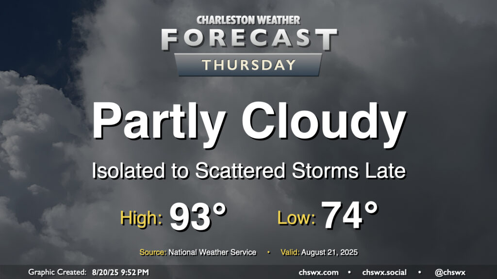
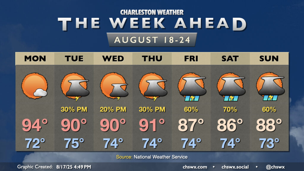
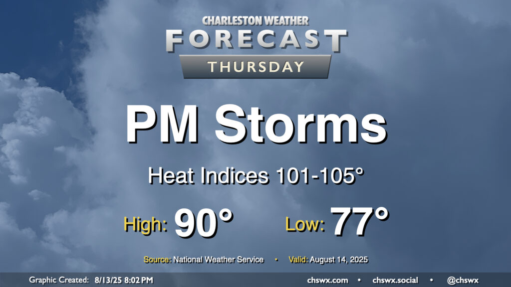
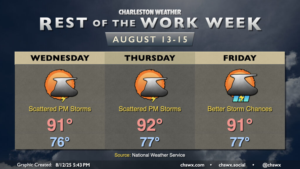
Thursday will be another warm day across the Lowcountry, with lows in the mid-70s warming to the low-to-mid-90s in the afternoon. Heat indices will run in the upper 90s to perhaps 100° in spots under generally partly cloudy skies. We should start to see cloud cover begin to thicken a bit as we get into the afternoon and evening hours, though, with rain chances increasing as Hurricane Erin accelerates to the northeast and a cold front drives south into the area, stalling out as it gets to our south.
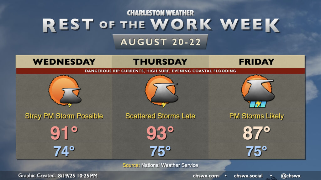
The main story for the next couple days will be Hurricane Erin’s impacts on the Lowcountry. While not a direct hit — the storm will pass hundreds of miles offshore — the strong, dangerous rip currents and high surf will cause beach erosion and coastal flooding issues over the next few days.
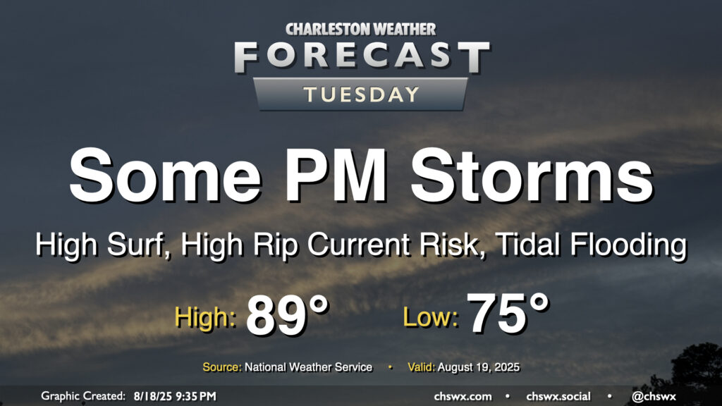
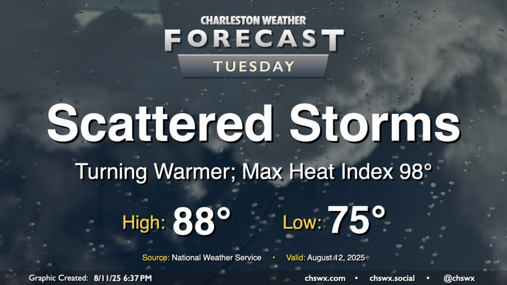
After an uncharacteristically quiet Monday (weather-wise, anyway), Tuesday should feature a few more storms as a little energy aloft moves through and interacts with the afternoon seabreeze. Temperatures start in the mid-70s, warming to the upper 80s to around 90° before thunderstorms disrupt the temperature curve for some of us. Models do indicate some isolated heavy downpours, though with less in the way of deep moisture, the flooding threat shouldn’t be terribly high.
The week ahead starts out on a warm note with high pressure in play before turning more unsettled by the time we get into the weekend. Meanwhile, Hurricane Erin will be passing offshore, sparing us direct impacts but kicking up high surf, a risk for dangerous rip currents, and even some coastal flooding in the evenings.
More storms are in the offing for Saturday as a front slides southward across the area, eventually stalling out across Georgia. This front, though, brings us a slightly cooler and drier airmass that filters into the area starting Sunday.
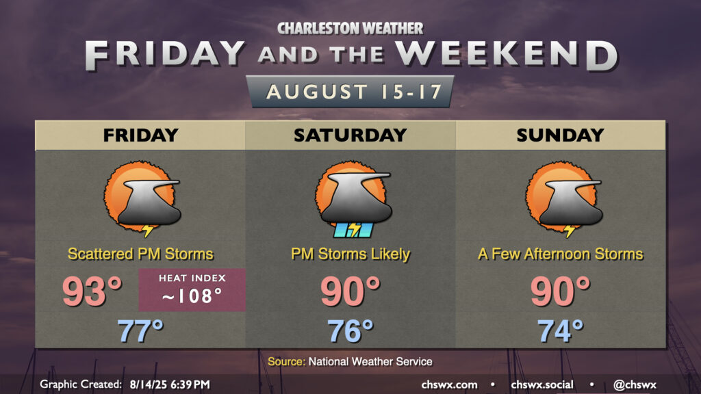
Another hot day is ahead Friday as heat indices once again climb well into the 100s under partly cloudy skies before thunderstorms develop along and ahead of the seabreeze in the afternoon. These will be generally scattered in nature — not everyone will see a storm, but those who do could get a quick round of heavy rain and gusty winds along with a good bit of lightning.
Better storm chances arrive on Saturday as a front sags south and eventually falls apart. Many of us should see a storm on Saturday, particularly in the afternoon, with plenty of triggers available for thunderstorm development. This should also help keep temperatures pinned to around 90° — still hot, but not as hot.
Lower dewpoints move in with northeast flow behind the front, giving us a little less humidity to deal with and slightly cooler temperatures as well. Ridging aloft will persist, allowing highs to get to around 90°, while a few showers and thunderstorms will be possible on the seabreeze each afternoon. We’ll keep this going into next week, too.
Thursday will be a fairly typical mid-August day across the area. We’ll start in the mid-to-upper 70s, warming to around 90° in the afternoon with heat indices generally running in the low to mid-100s given continued dewpoints in the mid-to-upper-70s, highest downtown and along the coast with closer proximity to the water. Once again, showers and thunderstorms should fire on the seabreeze in the afternoon, and a couple of those could be on the strong side with frequent lightning and gusty winds. Winds out of the west will drive showers and storms coastward, so keep an eye on this if you’re taking a day at the beach (you lucky duck).
90° temperatures have been tough to come by so far this August. (Please note this is not necessarily a complaint.) Since August 1, only today (August 12) has been a 90° day. It’ll get a little easier to achieve the 90° mark going forward, though, as ridging aloft continues to build in. High pressure in the mid-levels helps temperatures heat up while keeping more widespread thunderstorm activity tamped down. We’ll have plenty of humidity in play, which will allow heat indices to head into the low 100s each afternoon — hot for sure, but not Heat Advisory hot, at least. And yes, there will be a chance for a few thunderstorms each day primarily along and ahead of the seabreeze (with perhaps better coverage on Friday). A couple storms could turn strong or even severe where outflow boundaries collide, and heavy rainfall is certainly a concern as well given deep moisture. However, once again, we’ve had much worse very recently, and shouldn’t have a replay of the past weekend for a bit. Just be ready to head indoors in case thunderstorms approach, and you’ll be fine.
After a rambunctious Monday that featured widespread showers and thunderstorms leading to flash flooding downtown as well as a lightning strike caught on camera in Mt. Pleasant, the weather will return to a more traditional summertime pattern beginning Tuesday as Charleston County heads back to class. Temperatures will start on the mild side, generally in the mid-to-upper 70s, warming to the upper 80s in the afternoon. Mix in the continued humidity, and it’ll feel closer to 98°. Scattered showers and storms should fire again in the afternoon along and ahead of the seabreeze, and yes, there is a risk of heavy rain with these storms, but the risk for flash flooding will be a bit lower especially as storm motions should be a bit faster.