Jared Smith founded @chswx on Twitter in 2008 as an experiment in disseminating weather data through social media. In the ensuing decade-and-a-half, @chswx has provided live coverage of tropical cyclones, tornadoes, severe weather, and even a couple bouts of winter weather to the good people of Charleston, SC.
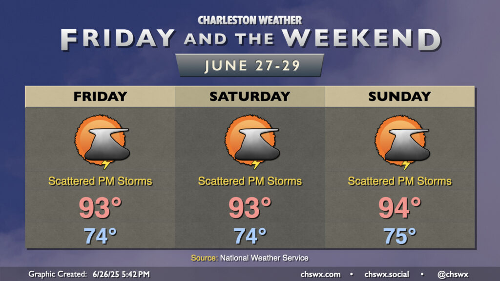
A fairly standard summer setup will take shape for Friday and the weekend as high pressure in the Atlantic ridges westward across the area, keeping temperatures warm and humid with daily storm chances. We can generally expect temperatures to start in the mid-70s each morning, with temperatures warming to the low to mid-90s each afternoon as our run of 90° days dating back to June 14 continues. Dewpoints ahead of the seabreeze will mix out with some drier air aloft to keep heat indices from getting too far out of hand, with apparent temperatures running just 3 or 4° warmer than air temperatures. Still, if you have vulnerability to the heat, be mindful of too much strenuous activity during the afternoons.
We should see isolated to scattered showers and thunderstorms fire along and ahead of the seabreeze each afternoon. The risk for severe weather is very low, but there’s always the risk for a storm or two to briefly turn strong to severe especially where thunderstorm outflow boundaries collide. Remember, all thunderstorms are dangerous because of the lightning they produce. When thunder roars, go indoors!
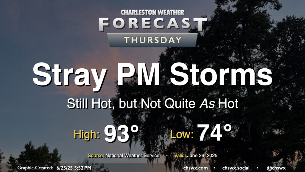
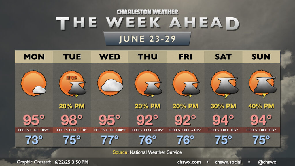
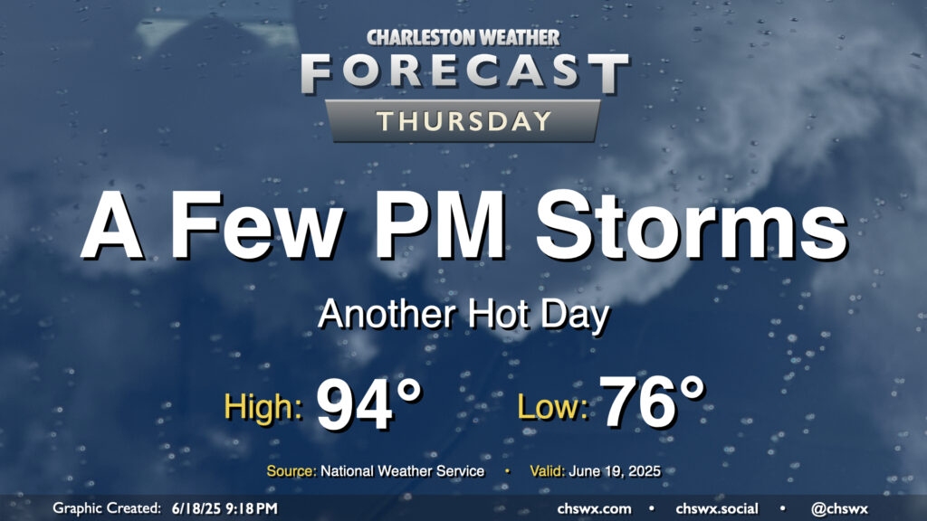
The high heat of the past couple days — we hit 98° again on Wednesday, just one degree off the record high — will let up on Thursday as high pressure aloft continues to weaken. Don’t misunderstand: it’ll still be plenty hot, but not to the Advisory-level thresholds we’ve hit recently. After a start in the mid-70s, likely in the wake of thunderstorms that are expected late tonight into early Thursday morning, temperatures in the afternoon warm to the low 90s. Dewpoints will mix down to around 70°, so heat indices should stay relatively tame, with a brief spike into the upper 90s possible as the seabreeze pushes inland. A few showers and thunderstorms could pop on the seabreeze, as is often the case this time of year, but nothing out-of-bounds is expected.
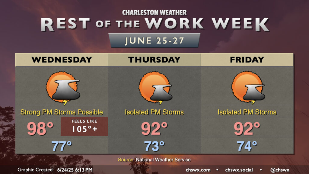
After reaching 98° today at the airport and 95° downtown, another very hot day awaits for Wednesday as air temperatures should once again make a run for the upper 90s in the afternoon, with heat indices once again peaking in the mid-to-upper 100s.
We will need to keep an eye on the skies on Wednesday afternoon and evening, though, as several of the high-resolution models suggest some sort of thunderstorm complex will develop in southern North Carolina and move southwest through the afternoon and evening hours. Plenty of instability will be available, and there will be a risk for these thunderstorms to produce strong, damaging winds. NWS’s current thinking on timing for any severe storms would be from 6PM-midnight, with the best risk for severe weather inland of Highway 17. We’ll keep an eye on this throughout tomorrow and will update as needed.
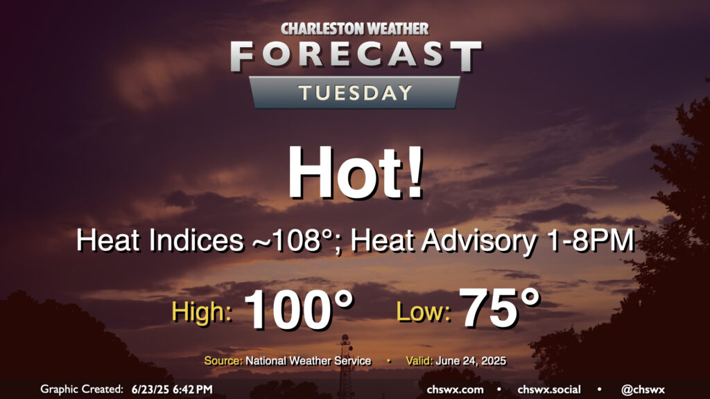
A very hot Tuesday is in the offing as high pressure at the surface and aloft remain in place, allowing temperatures to head into the upper 90s to around 100° across the area away from the coast, where temperatures should peak in the low to mid-90s. Regardless of where you are, heat indices should peak around 108-109° as well, prompting a Heat Advisory for the Tri-County area — the first of 2025 — that’ll go from 1-8 PM. If you are working outdoors during that period in particular, be sure you’re getting plenty of fluids and taking frequent breaks in the shade or, preferably, an air-conditioned environment. Be very vigilant about any children or pets in the car, too — it doesn’t take very long at all for temperatures to become very dangerous in cars, and we don’t want any hot car deaths. Look before you lock!
If a high of 100° verifies at the airport, it would be the first time since May 29, 2019 (the Before Times!) that the temperature at the airport reached 100° or higher. Triple-digit heat isn’t expected east of 17, including in downtown Charleston and at the beaches, but the closer proximity to higher-dewpoint maritime air will still send heat indices into the danger zone despite the lower air temperatures.
Looking for thunderstorms to cool you off? I wouldn’t count on it, though a stray storm can never be fully ruled out this time of year.
The main weather story this week will be heat, especially for the first part of the week as strong high pressure aloft affects much of the Eastern Seaboard.
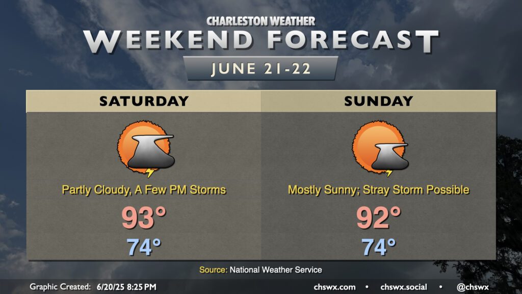
Summer heat will continue this weekend with limited chances for a few storms to cool things off. Saturday will start in the mid-70s, warming to the low-to-mid-90s in the afternoon. Mix in dewpoints in the low 70s, and it’ll feel more like the mid-to-upper 90s. There will be a bit more moisture available Saturday, which could allow for slightly greater storm coverage as the seabreeze pushes inland during the afternoon. However, most of us shouldn’t count on a storm to cool things off. Any storms that fire will dissipate with the loss of daytime heating.
A stray storm or two will be possible Sunday, but the vast majority of us should stay rain-free as dewpoints once again mix down to the low 70s in the afternoon owing to a lot of dry air aloft. We’ll warm to the low 90s, but the lower dewpoints keep heat indices relatively in check, only running a few degrees above the air temperature. That’s not to say that feeling like the mid-90s is in any way “cool” though!
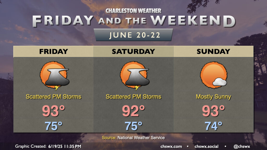
As we reach the summer solstice late Friday night (10:20 PM, to be exact), the weather will be seasonally appropriate. We can generally expect temperature in the low to mid-90s each afternoon after muggy starts in the mid-70s. Showers and thunderstorms will be possible particularly Friday and Saturday afternoons along and ahead of the seabreeze, though updrafts will struggle against high pressure building in aloft. In fact, we should generally see a lid on things for Sunday, making for a mostly sunny day. Heat indices will still run in the upper 90s to around 100°, so be sure you’re getting plenty of water and rest if you’re working or playing outside.
More heat and humidity are on tap for Thursday, but with a slightly better chance of storms in the afternoon especially as a front gets closer to the area. We’ll start the day in the mid-70s once again, warming back to the mid-90s in the afternoon. We’ll be keeping an eye on a line of thunderstorms to our northwest, which could help induce some stronger storms in the metro later in the afternoon through the evening hours. Damaging wind gusts would be the primary concern in the strongest storms, though the risk for severe weather is generally low (but not zero) across the area.
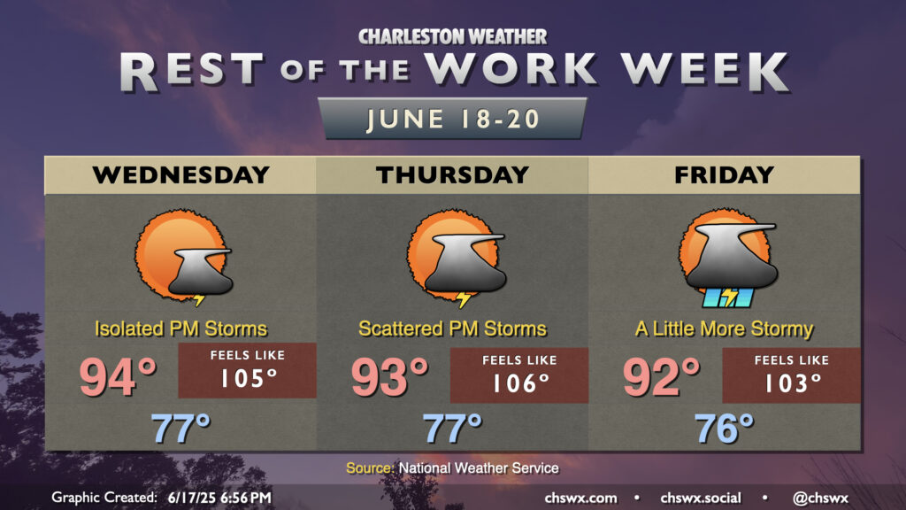
The rest of the work week will remain quite warm, especially Wednesday and Thursday as less in the way of showers and thunderstorms are expected before a trough of low pressure and accompanying front swing through to stir up more storms for Friday.
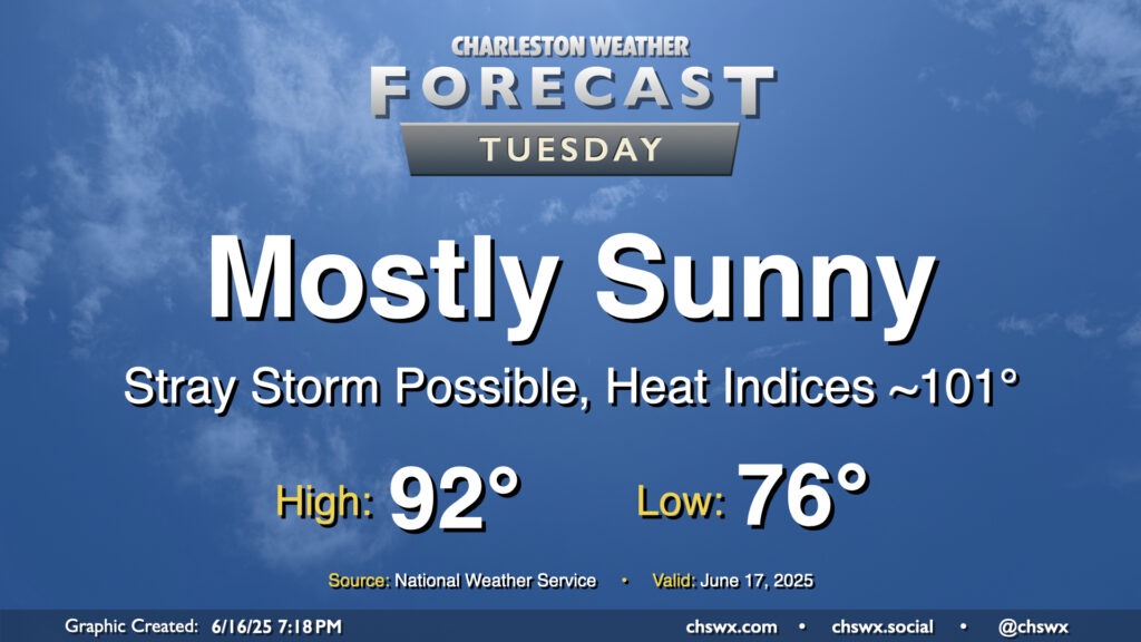
High pressure will continue to build in aloft, sending temperatures upward and storm chances downward. Tuesday will be another rather warm day, with lows in the mid-70s to start the day warming to the low 90s in the afternoon. Mix in dewpoints running in the low 70s, and that’ll yield heat indices right around the 100-101° mark during the height of the afternoon. Heat indices could even briefly spike in the immediate wake of the seabreeze as dewpoints surge before temperatures start to fall.
A storm or two will be possible along and ahead of the seabreeze, but with the capped atmosphere, it’s going to be tough to get much, if anything, to break through, much less sustain itself. Still, though, you can never completely rule it out this time of year.